Visual Localization for Autonomous Driving: Mapping the Accurate Location in the City Maze

Dongfang Liu, Yiming Cui, Xiaolei Guo, Wei Ding, Baijian Yang, Yingjie Chen

Responsive image

Auto-TLDR; Feature Voting for Robust Visual Localization in Urban Settings

Slides Poster

Accurate localization is a foundational capacity, required for autonomous vehicles to accomplish other tasks such as navigation or path planning. It is a common practice for vehicles to use GPS to acquire location information. However, the application of GPS can result in severe challenges when vehicles run within the inner city where different kinds of structures may shadow the GPS signal and lead to inaccurate location results. To address the localization challenges of urban settings, we propose a novel feature voting technique for visual localization. Different from the conventional front-view-based method, our approach employs views from three directions (front, left, and right) and thus significantly improves the robustness of location prediction. In our work, we craft the proposed feature voting method into three state-of-the-art visual localization networks and modify their architectures properly so that they can be applied for vehicular operation. Extensive field test results indicate that our approach can predict location robustly even in challenging inner-city settings. Our research sheds light on using the visual localization approach to help autonomous vehicles to find accurate location information in a city maze, within a desirable time constraint.

Similar papers

RISEdb: A Novel Indoor Localization Dataset

Carlos Sanchez Belenguer, Erik Wolfart, Álvaro Casado Coscollá, Vitor Sequeira

Responsive image

Auto-TLDR; Indoor Localization Using LiDAR SLAM and Smartphones: A Benchmarking Dataset

Slides Poster Similar

In this paper we introduce a novel public dataset for developing and benchmarking indoor localization systems. We have selected and 3D mapped a set of representative indoor environments including a large office building, a conference room, a workshop, an exhibition area and a restaurant. Our acquisition pipeline is based on a portable LiDAR SLAM backpack to map the buildings and to accurately track the pose of the user as it moves freely inside them. We introduce the calibration procedures that enable us to acquire and geo-reference live data coming from different independent sensors rigidly attached to the backpack. This has allowed us to collect long sequences of spherical and stereo images, together with all the sensor readings coming from a consumer smartphone and locate them inside the map with centimetre accuracy. The dataset addresses many of the limitations of existing indoor localization datasets regarding the scale and diversity of the mapped buildings; the number of acquired sequences under varying conditions; the accuracy of the ground-truth trajectory; the availability of a detailed 3D model and the availability of different sensor types. It enables the benchmarking of existing and the development of new indoor localization approaches, in particular for deep learning based systems that require large amounts of labeled training data.

Street-Map Based Validation of Semantic Segmentation in Autonomous Driving

Laura Von Rueden, Tim Wirtz, Fabian Hueger, Jan David Schneider, Nico Piatkowski, Christian Bauckhage

Responsive image

Auto-TLDR; Semantic Segmentation Mask Validation Using A-priori Knowledge from Street Maps

Slides Poster Similar

Artificial intelligence for autonomous driving must meet strict requirements on safety and robustness, which motivates the thorough validation of learned models. However, current validation approaches mostly require ground truth data and are thus both cost-intensive and limited in their applicability. We propose to overcome these limitations by a model agnostic validation using a-priori knowledge from street maps. In particular, we show how to validate semantic segmentation masks and demonstrate the potential of our approach using OpenStreetMap. We introduce validation metrics that indicate false positive or negative road segments. Besides the validation approach, we present a method to correct the vehicle's GPS position so that a more accurate localization can be used for the street map based validation. Lastly, we present quantitative results on the Cityscapes dataset indicating that our validation approach can indeed uncover errors in semantic segmentation masks.

Exploiting Local Indexing and Deep Feature Confidence Scores for Fast Image-To-Video Search

Savas Ozkan, Gözde Bozdağı Akar

Responsive image

Auto-TLDR; Fast and Robust Image-to-Video Retrieval Using Local and Global Descriptors

Slides Poster Similar

Cost-effective visual representation and fast query-by-example search are two challenging goals hat should be provided for web-scale visual retrieval task on a moderate hardware. In this paper, we introduce a fast yet robust method that ensures both of these goals by obtaining the state-of-the-art results for an image-to-video search scenario. To this end, we present important enhancements to commonly used indexing and visual representation techniques by promoting faster, better and more moderate retrieval performance. We also boost the effectiveness of the method for visual distortion by exploiting the individual decision results of local and global descriptors in the query time. By this way, local content descriptors effectively represent copied / duplicated scenes with large geometric deformations, while global descriptors for near duplicate and semantic searches are more practical. Experiments are conducted on the large-scale Stanford I2V dataset. The experimental results show that the method is effective in terms of complexity and query processing time for large-scale visual retrieval scenarios, even if local and global representations are used together. In addition, the proposed method is fairly accurate and achieves state-of-the-art performance based on the mAP score of the dataset. Lastly, we report additional mAP scores after updating the ground annotations obtained by the retrieval results of the proposed method showing more clearly the actual performance.

Vehicle Lane Merge Visual Benchmark

Kai Cordes, Hellward Broszio

Responsive image

Auto-TLDR; A Benchmark for Automated Cooperative Maneuvering Using Multi-view Video Streams and Ground Truth Vehicle Description

Slides Poster Similar

Automated driving is regarded as the most promising technology for improving road safety in the future. In this context, connected vehicles have an important role regarding their ability to perform cooperative maneuvers for challenging traffic situations. We propose a benchmark for automated cooperative maneuvers. The targeted cooperative maneuver is the vehicle lane merge where a vehicle on the acceleration lane merges into the traffic of a motorway. The benchmark enables the evaluation of vehicle localization approaches as well as the study of cooperative maneuvers. It consists of temporally synchronized multi-view video streams, highly accurate camera calibration, and ground truth vehicle descriptions, including position, heading, speed, and shape. For benchmark generation, the lane merge maneuver is performed by human drivers on a test track, resulting in 120 lane merge data sets with various traffic situations and video recording conditions.

Can You Trust Your Pose? Confidence Estimation in Visual Localization

Luca Ferranti, Xiaotian Li, Jani Boutellier, Juho Kannala

Responsive image

Auto-TLDR; Pose Confidence Estimation in Large-Scale Environments: A Light-weight Approach to Improving Pose Estimation Pipeline

Slides Poster Similar

Camera pose estimation in large-scale environments is still an open question and, despite recent promising results, it may still fail in some situations. The research so far has focused on improving subcomponents of estimation pipelines, to achieve more accurate poses. However, there is no guarantee for the result to be correct, even though the correctness of pose estimation is critically important in several visual localization applications, such as in autonomous navigation. In this paper we bring to attention a novel research question, pose confidence estimation, where we aim at quantifying how reliable the visually estimated pose is. We develop a novel confidence measure to fulfill this task and show that it can be flexibly applied to different datasets, indoor or outdoor, and for various visual localization pipelines. We also show that the proposed techniques can be used to accomplish a secondary goal: improving the accuracy of existing pose estimation pipelines. Finally, the proposed approach is computationally light-weight and adds only a negligible increase to the computational effort of pose estimation.

Do We Really Need Scene-Specific Pose Encoders?

Yoli Shavit, Ron Ferens

Responsive image

Auto-TLDR; Pose Regression Using Deep Convolutional Networks for Visual Similarity

Slides Similar

Visual pose regression models estimate the camera pose from a query image with a single forward pass. Current models learn pose encoding from an image using deep convolutional networks which are trained per scene. The resulting encoding is typically passed to a multi-layer perceptron in order to regress the pose. In this work, we propose that scene-specific pose encoders are not required for pose regression and that encodings trained for visual similarity can be used instead. In order to test our hypothesis, we take a shallow architecture of several fully connected layers and train it with pre-computed encodings from a generic image retrieval model. We find that these encodings are not only sufficient to regress the camera pose, but that, when provided to a branching fully connected architecture, a trained model can achieve competitive results and even surpass current state-of-the-art pose regressors in some cases. Moreover, we show that for outdoor localization, the proposed architecture is the only pose regressor, to date, consistently localizing in under 2 meters and 5 degrees.

Real-Time End-To-End Lane ID Estimation Using Recurrent Networks

Ibrahim Halfaoui, Fahd Bouzaraa, Onay Urfalioglu

Responsive image

Auto-TLDR; Real-Time, Vision-Only Lane Identification Using Monocular Camera

Slides Poster Similar

Acquiring information about the road lane structure is a crucial step for autonomous navigation. To this end, several approaches tackle this task from different perspectives such as lane marking detection or semantic lane segmentation.However, to the best of our knowledge, there is yet no purely vision based end-to-end solution to answer the precise question: How to estimate the relative number or "ID" of the current driven lane within a multi-lane road or a highway? In this work, we propose a real-time, vision-only (i.e. monocular camera) solution to the problem based on a dual left-right convention. We interpret this task as a classification problem by limiting the maximum number of lane candidates to eight. Our approach is designed to meet low-complexity specifications and limited runtime requirements. It harnesses the temporal dimension inherent to the input sequences to improve upon high complexity state-of-the-art models. We achieve more than 95% accuracy on a challenging test set with extreme conditions and different routes.

A Fine-Grained Dataset and Its Efficient Semantic Segmentation for Unstructured Driving Scenarios

Kai Andreas Metzger, Peter Mortimer, Hans J "Joe" Wuensche

Responsive image

Auto-TLDR; TAS500: A Semantic Segmentation Dataset for Autonomous Driving in Unstructured Environments

Slides Poster Similar

Research in autonomous driving for unstructured environments suffers from a lack of semantically labeled datasets compared to its urban counterpart. Urban and unstructured outdoor environments are challenging due to the varying lighting and weather conditions during a day and across seasons. In this paper, we introduce TAS500, a novel semantic segmentation dataset for autonomous driving in unstructured environments. TAS500 offers fine-grained vegetation and terrain classes to learn drivable surfaces and natural obstacles in outdoor scenes effectively. We evaluate the performance of modern semantic segmentation models with an additional focus on their efficiency. Our experiments demonstrate the advantages of fine-grained semantic classes to improve the overall prediction accuracy, especially along the class boundaries. The dataset, code, and pretrained model are available online.

Map-Based Temporally Consistent Geolocalization through Learning Motion Trajectories

Bing Zha, Alper Yilmaz

Responsive image

Auto-TLDR; Exploiting Motion Trajectories for Geolocalization of Object on Topological Map using Recurrent Neural Network

Slides Poster Similar

In this paper, we propose a novel trajectory learning method that exploits motion trajectories on topological map using recurrent neural network for temporally consistent geolocalization of object. Inspired by human's ability to both be aware of distance and direction of self-motion in navigation, our trajectory learning method learns a pattern representation of trajectories encoded as a sequence of distances and turning angles to assist self-localization. We pose the learning process as a conditional sequence prediction problem in which each output locates the object on a traversable edge in a map. Considering the prediction sequence ought to be topologically connected in the graph-structured map, we adopt two different hypotheses generation and elimination strategies to eliminate disconnected sequence prediction. We demonstrate our approach on the KITTI stereo visual odometry dataset which is a city-scale environment. The key benefits of our approach to geolocalization are that 1) we take advantage of powerful sequence modeling ability of recurrent neural network and its robustness to noisy input, 2) only require a map in the form of a graph and 3) simply use an affordable sensor that generates motion trajectory. The experiments show that the motion trajectories can be learned by training an recurrent neural network, and temporally consistent geolocation can be predicted with both of the proposed strategies.

Holistic Grid Fusion Based Stop Line Estimation

Runsheng Xu, Faezeh Tafazzoli, Li Zhang, Timo Rehfeld, Gunther Krehl, Arunava Seal

Responsive image

Auto-TLDR; Fused Multi-Sensory Data for Stop Lines Detection in Intersection Scenarios

Slides Similar

Intersection scenarios provide the most complex traffic situations in Autonomous Driving and Driving Assistance Systems. Knowing where to stop in advance in an intersection is an essential parameter in controlling the longitudinal velocity of the vehicle. Most of the existing methods in literature solely use cameras to detect stop lines, which is typically not sufficient in terms of detection range. To address this issue, we propose a method that takes advantage of fused multi-sensory data including stereo camera and lidar as input and utilizes a carefully designed convolutional neural network architecture to detect stop lines. Our experiments show that the proposed approach can improve detection range compared to camera data alone, works under heavy occlusion without observing the ground markings explicitly, is able to predict stop lines for all lanes and allows detection at a distance up to 50 meters.

Extending Single Beam Lidar to Full Resolution by Fusing with Single Image Depth Estimation

Yawen Lu, Yuxing Wang, Devarth Parikh, Guoyu Lu

Responsive image

Auto-TLDR; Self-supervised LIDAR for Low-Cost Depth Estimation

Slides Similar

Depth estimation is playing an important role in indoor and outdoor scene understanding, autonomous driving, augmented reality and many other tasks. Vehicles and robotics are able to use active illumination sensors such as LIDAR to receive high precision depth estimation. However, high-resolution Lidars are usually too expensive, which limits its massive production on various applications. Though single beam LIDAR enjoys the benefits of low cost, one beam depth sensing is not usually sufficient to perceive the surrounding environment in many scenarios. In this paper, we propose a learning-based framework to explore to replicate similar or even higher performance as costly LIDARs with our designed self-supervised network and a low-cost single-beam LIDAR. After the accurate calibration with a visible camera, the single beam LIDAR can adjust the scale uncertainty of the depth map estimated by the visible camera. The adjusted depth map enjoys the benefits of high resolution and sensing accuracy as high beam LIDAR and maintains low-cost as single beam LIDAR. Thus we can achieve similar sensing effect of high beam LIDAR with more than a 50-100 times cheaper price (e.g., \$80000 Velodyne HDL-64E LIDAR v.s. \$1000 SICK TIM-781 2D LIDAR and normal camera). The proposed approach is verified on our collected dataset and public dataset with superior depth-sensing performance.

Loop-closure detection by LiDAR scan re-identification

Jukka Peltomäki, Xingyang Ni, Jussi Puura, Joni-Kristian Kamarainen, Heikki Juhani Huttunen

Responsive image

Auto-TLDR; Loop-Closing Detection from LiDAR Scans Using Convolutional Neural Networks

Slides Poster Similar

In this work, loop-closure detection from LiDAR scans is defined as an image re-identification problem. Re-identification is performed by computing Euclidean distances of a query scan to a gallery set of previous scans. The distances are computed in a feature embedding space where the scans are mapped by a convolutional neural network (CNN). The network is trained using the triplet loss training strategy. In our experiments we compare different backbone networks, variants of the triplet loss and generic and LiDAR specific data augmentation techniques. With a realistic indoor dataset the best architecture obtains the mean average precision (mAP) above 90%.

Attention Based Coupled Framework for Road and Pothole Segmentation

Shaik Masihullah, Ritu Garg, Prerana Mukherjee, Anupama Ray

Responsive image

Auto-TLDR; Few Shot Learning for Road and Pothole Segmentation on KITTI and IDD

Slides Poster Similar

In this paper, we propose a novel attention based coupled framework for road and pothole segmentation. In many developing countries as well as in rural areas, the drivable areas are neither well-defined, nor well-maintained. Under such circumstances, an Advance Driver Assistant System (ADAS) is needed to assess the drivable area and alert about the potholes ahead to ensure vehicle safety. Moreover, this information can also be used in structured environments for assessment and maintenance of road health. We demonstrate few shot learning approach for pothole detection to leverage accuracy even with fewer training samples. We report the exhaustive experimental results for road segmentation on KITTI and IDD datasets. We also present pothole segmentation on IDD.

Automatically Gather Address Specific Dwelling Images Using Google Street View

Salman Khan, Carl Salvaggio

Responsive image

Auto-TLDR; Automatic Address Specific Dwelling Image Collection Using Google Street View Data

Slides Poster Similar

Exciting research is being conducted using Google’s street view imagery. Researchers can have access to training data that allows CNN training for topics ranging from assessing neighborhood environments to estimating the age of a building. However, due to the uncontrolled nature of imagery available via Google’s Street View API, data collection can be lengthy and tedious. In an effort to help researchers gather address specific dwelling images efficiently, we developed an innovative and novel way of automatically performing this task. It was accomplished by exploiting Google’s publicly available platform with a combination of 3 separate network types and postprocessing techniques. Our uniquely developed NMS technique helped achieve 99.4%, valid, address specific dwelling images.

Two-Stage Adaptive Object Scene Flow Using Hybrid CNN-CRF Model

Congcong Li, Haoyu Ma, Qingmin Liao

Responsive image

Auto-TLDR; Adaptive object scene flow estimation using a hybrid CNN-CRF model and adaptive iteration

Slides Poster Similar

Scene flow estimation based on stereo sequences is a comprehensive task relevant to disparity and optical flow. Some existing methods are time-consuming and often fail in the presence of reflective surfaces. In this paper, we propose a two-stage adaptive object scene flow estimation method using a hybrid CNN-CRF model (ACOSF), which benefits from high-quality features and the structured modelling capability. Meanwhile, in order to balance the computational efficiency and accuracy, we employ adaptive iteration for energy function optimization, which is flexible and efficient for various scenes. Besides, we utilize high-quality pixel selection to reduce the computation time with only a slight decrease in accuracy. Our method achieves competitive results with the state-of-the-art, which ranks second on the challenging KITTI 2015 scene flow benchmark.

FC-DCNN: A Densely Connected Neural Network for Stereo Estimation

Dominik Hirner, Friedrich Fraundorfer

Responsive image

Auto-TLDR; FC-DCNN: A Lightweight Network for Stereo Estimation

Slides Poster Similar

We propose a novel lightweight network for stereo estimation. Our network consists of a fully-convolutional densely connected neural network (FC-DCNN) that computes matching costs between rectified image pairs. Our FC-DCNN method learns expressive features and performs some simple but effective post-processing steps. The densely connected layer structure connects the output of each layer to the input of each subsequent layer. This network structure in addition to getting rid of any fully-connected layers leads to a very lightweight network. The output of this network is used in order to calculate matching costs and create a cost-volume. Instead of using time and memory-inefficient cost-aggregation methods such as semi-global matching or conditional random fields in order to improve the result, we rely on filtering techniques, namely median filter and guided filter. By computing a left-right consistency check we get rid of inconsistent values. Afterwards we use a watershed foreground-background segmentation on the disparity image with removed inconsistencies. This mask is then used to refine the final prediction. We show that our method works well for both challenging indoor and outdoor scenes by evaluating it on the Middlebury, KITTI and ETH3D benchmarks respectively.

Multi-Scale Keypoint Matching

Sina Lotfian, Hassan Foroosh

Responsive image

Auto-TLDR; Multi-Scale Keypoint Matching Using Multi-Scale Information

Slides Poster Similar

We propose a new hierarchical method to match keypoints by exploiting information across multiple scales. Traditionally, for each keypoint a single scale is detected and the matching process is done in the specific scale. We replace this approach with matching across scale-space. The holistic information from higher scales are used for early rejection of candidates that are far away in the feature space. The more localized and finer details of lower scale are then used to decide between remaining possible points. The proposed multi-scale solution is more consistent with the multi-scale processing that is present in the human visual system and is therefore biologically plausible. We evaluate our method on several datasets and achieve state of the art accuracy, while significantly outperforming others in extraction time.

Derivation of Geometrically and Semantically Annotated UAV Datasets at Large Scales from 3D City Models

Sidi Wu, Lukas Liebel, Marco Körner

Responsive image

Auto-TLDR; Large-Scale Dataset of Synthetic UAV Imagery for Geometric and Semantic Annotation

Slides Poster Similar

While in high demand for the development of deep learning approaches, extensive datasets of annotated UAV imagery are still scarce today. Manual annotation, however, is time-consuming and, thus, has limited the potential for creating large-scale datasets. We tackle this challenge by presenting a procedure for the automatic creation of simulated UAV image sequences in urban areas and pixel-level annotations from publicly available data sources. We synthesize photo-realistic UAV imagery from Goole Earth Studio and derive annotations from an open CityGML model that not only provides geometric but also semantic information. The first dataset we exemplarily created using our approach contains 144000 images of Berlin, Germany, with four types of annotations, namely semantic labels as well as depth, surface normals, and edge maps. In the future, a complete pipeline regarding all the technical problems will be provided, together with more accurate models to refine some of the empirical settings currently, to automatically generate a large-scale dataset with reliable ground-truth annotations over the whole city of Berlin. The dataset, as well as the source code, will be published by then. Different methods will also be facilitated to test the usability of the dataset. We believe our dataset can be used for, and not limited to, tasks like pose estimation, geo-localization, monocular depth estimation, edge detection, building/surface classification, and plane segmentation. A potential research pipeline for geo-localization based on the synthetic dataset is provided.

Deep Next-Best-View Planner for Cross-Season Visual Route Classification

Kurauchi Kanya, Kanji Tanaka

Responsive image

Auto-TLDR; Active Visual Place Recognition using Deep Convolutional Neural Network

Slides Poster Similar

This paper addresses the problem of active visual place recognition (VPR) from a novel perspective of long-term autonomy. In our approach, a next-best-view (NBV) planner plans an optimal action-observation-sequence to maximize the expected cost-performance for a visual route classification task. A difficulty arises from the fact that the NBV planner is trained and tested in different domains (times of day, weather conditions, and seasons). Existing NBV methods may be confused and deteriorated by the domain-shifts, and require significant efforts for adapting them to a new domain. We address this issue by a novel deep convolutional neural network (DNN) -based NBV planner that does not require the adaptation. Our main contributions in this paper are summarized as follows: (1) We present a novel domain-invariant NBV planner that is specifically tailored for DNN-based VPR. (2) We formulate the active VPR as a POMDP problem and present a feasible solution to address the inherent intractability. Specifically, the probability distribution vector (PDV) output by the available DNN is used as a domain-invariant observation model without the need to retrain it. (3) We verify efficacy of the proposed approach through challenging cross-season VPR experiments, where it is confirmed that the proposed approach clearly outperforms the previous single-view-based or multi-view-based VPR in terms of VPR accuracy and/or action-observation-cost.

Multimodal End-To-End Learning for Autonomous Steering in Adverse Road and Weather Conditions

Jyri Sakari Maanpää, Josef Taher, Petri Manninen, Leo Pakola, Iaroslav Melekhov, Juha Hyyppä

Responsive image

Auto-TLDR; End-to-End Learning for Autonomous Steering in Adverse Road and Weather Conditions with Lidar Data

Slides Poster Similar

Autonomous driving is challenging in adverse road and weather conditions in which there might not be lane lines, the road might be covered in snow and the visibility might be poor. We extend the previous work on end-to-end learning for autonomous steering to operate in these adverse real-life conditions with multimodal data. We collected 28 hours of driving data in several road and weather conditions and trained convolutional neural networks to predict the car steering wheel angle from front-facing color camera images and lidar range and reflectance data. We compared the CNN model performances based on the different modalities and our results show that the lidar modality improves the performances of different multimodal sensor-fusion models. We also performed on-road tests with different models and they support this observation.

Rotation Invariant Aerial Image Retrieval with Group Convolutional Metric Learning

Hyunseung Chung, Woo-Jeoung Nam, Seong-Whan Lee

Responsive image

Auto-TLDR; Robust Remote Sensing Image Retrieval Using Group Convolution with Attention Mechanism and Metric Learning

Slides Poster Similar

Remote sensing image retrieval (RSIR) is the process of ranking database images depending on the degree of similarity compared to the query image. As the complexity of RSIR increases due to the diversity in shooting range, angle, and location of remote sensors, there is an increasing demand for methods to address these issues and improve retrieval performance. In this work, we introduce a novel method for retrieving aerial images by merging group convolution with attention mechanism and metric learning, resulting in robustness to rotational variations. For refinement and emphasis on important features, we applied channel attention in each group convolution stage. By utilizing the characteristics of group convolution and channel-wise attention, it is possible to acknowledge the equality among rotated but identically located images. The training procedure has two main steps: (i) training the network with Aerial Image Dataset (AID) for classification, (ii) fine-tuning the network with triplet-loss for retrieval with Google Earth South Korea and NWPU-RESISC45 datasets. Results show that the proposed method performance exceeds other state-of-the-art retrieval methods in both rotated and original environments. Furthermore, we utilize class activation maps (CAM) to visualize the distinct difference of main features between our method and baseline, resulting in better adaptability in rotated environments.

A Bayesian Approach to Reinforcement Learning of Vision-Based Vehicular Control

Zahra Gharaee, Karl Holmquist, Linbo He, Michael Felsberg

Responsive image

Auto-TLDR; Bayesian Reinforcement Learning for Autonomous Driving

Slides Poster Similar

In this paper, we present a state-of-the-art reinforcement learning method for autonomous driving. Our approach employs temporal difference learning in a Bayesian framework to learn vehicle control signals from sensor data. The agent has access to images from a forward facing camera, which are pre-processed to generate semantic segmentation maps. We trained our system using both ground truth and estimated semantic segmentation input. Based on our observations from a large set of experiments, we conclude that training the system on ground truth input data leads to better performance than training the system on estimated input even if estimated input is used for evaluation. The system is trained and evaluated in a realistic simulated urban environment using the CARLA simulator. The simulator also contains a benchmark that allows for comparing to other systems and methods. The required training time of the system is shown to be lower and the performance on the benchmark superior to competing approaches.

Multiple Future Prediction Leveraging Synthetic Trajectories

Lorenzo Berlincioni, Federico Becattini, Lorenzo Seidenari, Alberto Del Bimbo

Responsive image

Auto-TLDR; Synthetic Trajectory Prediction using Markov Chains

Slides Poster Similar

Trajectory prediction is an important task, especially in autonomous driving. The ability to forecast the position of other moving agents can yield to an effective planning, ensuring safety for the autonomous vehicle as well for the observed entities. In this work we propose a data driven approach based on Markov Chains to generate synthetic trajectories, which are useful for training a multiple future trajectory predictor. The advantages are twofold: on the one hand synthetic samples can be used to augment existing datasets and train more effective predictors; on the other hand, it allows to generate samples with multiple ground truths, corresponding to diverse equally likely outcomes of the observed trajectory. We define a trajectory prediction model and a loss that explicitly address the multimodality of the problem and we show that combining synthetic and real data leads to prediction improvements, obtaining state of the art results.

Multi-Level Deep Learning Vehicle Re-Identification Using Ranked-Based Loss Functions

Eleni Kamenou, Jesus Martinez-Del-Rincon, Paul Miller, Patricia Devlin - Hill

Responsive image

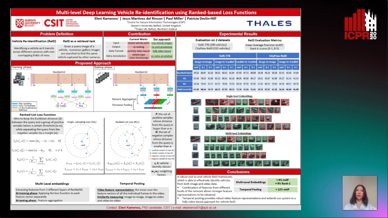
Auto-TLDR; Multi-Level Re-identification Network for Vehicle Re-Identification

Slides Poster Similar

Identifying vehicles across a network of cameras with non-overlapping fields of view remains a challenging research problem due to scene occlusions, significant inter-class similarity and intra-class variability. In this paper, we propose an end-to-end multi-level re-identification network that is capable of successfully projecting same identity vehicles closer to one another in the embedding space, compared to vehicles of different identities. Robust feature representations are obtained by combining features at multiple levels of the network. As for the learning process, we employ a recent state-of-the-art structured metric learning loss function previously applied to other retrieval problems and adjust it to the vehicle re-identification task. Furthermore, we explore the cases of image-to-image, image-to-video and video-to-video similarity metric. Finally, we evaluate our system and achieve great performance on two large-scale publicly available datasets, CityFlow-ReID and VeRi-776. Compared to most existing state-of-art approaches, our approach is simpler and more straightforward, utilizing only identity-level annotations, while avoiding post-processing the ranking results (re-ranking) at the testing phase.

On Identification and Retrieval of Near-Duplicate Biological Images: A New Dataset and Protocol

Thomas E. Koker, Sai Spandana Chintapalli, San Wang, Blake A. Talbot, Daniel Wainstock, Marcelo Cicconet, Mary C. Walsh

Responsive image

Auto-TLDR; BINDER: Bio-Image Near-Duplicate Examples Repository for Image Identification and Retrieval

Poster Similar

Manipulation and re-use of images in scientific publications is a growing issue, not only for biomedical publishers, but also for the research community in general. In this work we introduce BINDER -- Bio-Image Near-Duplicate Examples Repository, a novel dataset to help researchers develop, train, and test models to detect same-source biomedical images. BINDER contains 7,490 unique image patches for model training, 1,821 same-size patch duplicates for validation and testing, and 868 different-size image/patch pairs for image retrieval validation and testing. Except for the training set, patches already contain manipulations including rotation, translation, scale, perspective transform, contrast adjustment and/or compression artifacts. We further use the dataset to demonstrate how novel adaptations of existing image retrieval and metric learning models can be applied to achieve high-accuracy inference results, creating a baseline for future work. In aggregate, we thus present a supervised protocol for near-duplicate image identification and retrieval without any "real-world" training example. Our dataset and source code are available at hms-idac.github.io/BINDER.

NetCalib: A Novel Approach for LiDAR-Camera Auto-Calibration Based on Deep Learning

Shan Wu, Amnir Hadachi, Damien Vivet, Yadu Prabhakar

Responsive image

Auto-TLDR; Automatic Calibration of LiDAR and Cameras using Deep Neural Network

Slides Poster Similar

A fusion of LiDAR and cameras have been widely used in many robotics applications such as classification, segmentation, object detection, and autonomous driving. It is essential that the LiDAR sensor can measure distances accurately, which is a good complement to the cameras. Hence, calibrating sensors before deployment is a mandatory step. The conventional methods include checkerboards, specific patterns, or human labeling, which is trivial and human-labor extensive if we do the same calibration process every time. The main propose of this research work is to build a deep neural network that is capable of automatically finding the geometric transformation between LiDAR and cameras. The results show that our model manages to find the transformations from randomly sampled artificial errors. Besides, our work is open-sourced for the community to fully utilize the advances of the methodology for developing more the approach, initiating collaboration, and innovation in the topic.

Visual Prediction of Driver Behavior in Shared Road Areas

Peter Gawronski, Darius Burschka

Responsive image

Auto-TLDR; Predicting Vehicle Behavior in Shared Road Segment Intersections Using Topological Knowledge

Slides Poster Similar

We propose a framework to analyze and predict vehicles behavior within shared road segments like intersections or at narrow passages. The system first identifies critical interaction regions based on topological knowledge. It then checks possible colliding trajectories from the current state of vehicles in the scene, defined by overlapping occupation times in road segments. For each possible interaction area, it analyzes the behavioral profile of both vehicles. Depending on right of way and (unpredictable) behavior parameters, different outcomes are expected and will be tested against input. The interaction between vehicles is analyzed over a short time horizon based on an initial action from one vehicle and the reaction by the other. The vehicle to yield most often performs the first action and the response of the opponent vehicle is measured after a reaction time. The observed reaction is classified by attention, if there was a reaction at all, and the collaboration of the opponent vehicle, whether it helps to resolve the situation or hinders it. The output is a classification of behavior of involved vehicles in terms of active participation in the interaction and assertiveness of driving style in terms of collaborative or disruptive behavior. The additional knowledge is used to refine the prediction of intention and outcome of a scene, which is then compared to the current status to catch unexpected behavior. The applicability of the concept and ideas of the approach is validated on scenarios from the recent Intersection Drone (inD) data set.

RONELD: Robust Neural Network Output Enhancement for Active Lane Detection

Zhe Ming Chng, Joseph Mun Hung Lew, Jimmy Addison Lee

Responsive image

Auto-TLDR; Real-Time Robust Neural Network Output Enhancement for Active Lane Detection

Slides Poster Similar

Accurate lane detection is critical for navigation in autonomous vehicles, particularly the active lane which demarcates the single road space that the vehicle is currently traveling on. Recent state-of-the-art lane detection algorithms utilize convolutional neural networks (CNNs) to train deep learning models on popular benchmarks such as TuSimple and CULane. While each of these models works particularly well on train and test inputs obtained from the same dataset, the performance drops significantly on unseen datasets of different environments. In this paper, we present a real-time robust neural network output enhancement for active lane detection (RONELD) method to identify, track, and optimize active lanes from deep learning probability map outputs. We first adaptively extract lane points from the probability map outputs, followed by detecting curved and straight lanes before using weighted least squares linear regression on straight lanes to fix broken lane edges resulting from fragmentation of edge maps in real images. Lastly, we hypothesize true active lanes through tracking preceding frames. Experimental results demonstrate an up to two-fold increase in accuracy using RONELD on cross-dataset validation tests.

Benchmarking Cameras for OpenVSLAM Indoors

Kevin Chappellet, Guillaume Caron, Fumio Kanehiro, Ken Sakurada, Abderrahmane Kheddar

Responsive image

Auto-TLDR; OpenVSLAM: Benchmarking Camera Types for Visual Simultaneous Localization and Mapping

Slides Poster Similar

In this paper we benchmark different types of cameras and evaluate their performance in terms of reliable localization reliability and precision in Visual Simultaneous Localization and Mapping (vSLAM). Such benchmarking is merely found for visual odometry, but never for vSLAM. Existing studies usually compare several algorithms for a given camera. %This work is the first to handle the dual of the latter, i.e. comparing several cameras for a given SLAM algorithm. The evaluation methodology we propose is applied to the recent OpenVSLAM framework. The latter is versatile enough to natively deal with perspective, fisheye, 360 cameras in a monocular or stereoscopic setup, an in RGB or RGB-D modalities. Results in various sequences containing light variation and scenery modifications in the scene assess quantitatively the maximum localization rate for 360 vision. In the contrary, RGB-D vision shows the lowest localization rate, but highest precision when localization is possible. Stereo-fisheye trades-off with localization rates and precision between 360 vision and RGB-D vision. The dataset with ground truth will be made available in open access to allow evaluating other/future vSLAM algorithms with respect to these camera types.

End-To-End Deep Learning Methods for Automated Damage Detection in Extreme Events at Various Scales

Yongsheng Bai, Alper Yilmaz, Halil Sezen

Responsive image

Auto-TLDR; Robust Mask R-CNN for Crack Detection in Extreme Events

Slides Poster Similar

Robust Mask R-CNN (Mask Regional Convolutional Neural Network) methods are proposed and tested for automatic detection of cracks on structures or their components that may be damaged during extreme events, such as earth-quakes. We curated a new dataset with 2,021 labeled images for training and validation and aimed to find end-to-end deep neural networks for crack detection in the field. With data augmentation and parameters fine-tuning, Path Aggregation Network (PANet) with spatial attention mechanisms and High-resolution Network (HRNet) are introduced into Mask R-CNNs. The tests on three public datasets with low- or high-resolution images demonstrate that the proposed methods can achieve a big improvement over alternative networks, so the proposed method may be sufficient for crack detection for a variety of scales in real applications.

Large-Scale Historical Watermark Recognition: Dataset and a New Consistency-Based Approach

Xi Shen, Ilaria Pastrolin, Oumayma Bounou, Spyros Gidaris, Marc Smith, Olivier Poncet, Mathieu Aubry

Responsive image

Auto-TLDR; Historical Watermark Recognition with Fine-Grained Cross-Domain One-Shot Instance Recognition

Slides Poster Similar

Historical watermark recognition is a highly practical, yet unsolved challenge for archivists and historians. With a large number of well-defined classes, cluttered and noisy samples, different types of representations, both subtle differences between classes and high intra-class variation, historical watermarks are also challenging for pattern recognition. In this paper, overcoming the difficulty of data collection, we present a large public dataset with more than 6k new photographs, allowing for the first time to tackle at scale the scenarios of practical interest for scholars: one-shot instance recognition and cross-domain one-shot instance recognition amongst more than 16k fine-grained classes. We demonstrate that this new dataset is large enough to train modern deep learning approaches, and show that standard methods can be improved considerably by using mid-level deep features. More precisely, we design both a matching score and a feature fine-tuning strategy based on filtering local matches using spatial consistency. This consistency-based approach provides important performance boost compared to strong baselines. Our model achieves 55\% as top-1 accuracy on our very challenging 16,753-class one-shot cross-domain recognition task, each class described by a single drawing from the classic Briquet catalog. In addition to watermark classification, we show our approach provides promising results on fine-grained sketch-based image retrieval.

Visual Saliency Oriented Vehicle Scale Estimation

Qixin Chen, Tie Liu, Jiali Ding, Zejian Yuan, Yuanyuan Shang

Responsive image

Auto-TLDR; Regularized Intensity Matching for Vehicle Scale Estimation with salient object detection

Slides Poster Similar

Vehicle scale estimation with a single camera is a typical application for intelligent transportation and it faces the challenges from visual computing while intensity-based method and descriptor-based method should be balanced. This paper proposed a vehicle scale estimation method based on salient object detection to resolve this problem. The regularized intensity matching method is proposed in Lie Algebra to achieve robust and accurate scale estimation, and descriptor matching and intensity matching are combined to minimize the proposed loss function. The visual attention mechanism is designed to select image patches with texture and remove the occluded image patches. Then the weights are assigned to pixels from the selected image patches which alleviates the influence of noise-corrupted pixels. The experiments show that the proposed method significantly outperforms state-of-the-art methods with regard to the robustness and accuracy of vehicle scale estimation.

Temporal Pulses Driven Spiking Neural Network for Time and Power Efficient Object Recognition in Autonomous Driving

Wei Wang, Shibo Zhou, Jingxi Li, Xiaohua Li, Junsong Yuan, Zhanpeng Jin

Responsive image

Auto-TLDR; Spiking Neural Network for Real-Time Object Recognition on Temporal LiDAR Pulses

Slides Poster Similar

Accurate real-time object recognition from sensory data has long been a crucial and challenging task for autonomous driving. Even though deep neural networks (DNNs) have been widely applied in this area, their considerable processing latency, power consumption as well as computational complexity have been challenging issues for real-time autonomous driving applications. In this paper, we propose an approach to address the real-time object recognition problem utilizing spiking neural networks (SNNs). The proposed SNN model works directly with raw temporal LiDAR pulses without the pulse-to-point cloud preprocessing procedure, which can significantly reduce delay and power consumption. Being evaluated on various datasets derived from LiDAR and dynamic vision sensor (DVS), including Sim LiDAR, KITTI, and DVS-barrel, our proposed model has shown remarkable time and power efficiency, while achieving comparable recognition performance as the state-of-the-art methods. This paper highlights the SNN's great potentials in autonomous driving and related applications. To the best of our knowledge, this is the first attempt to use SNN to directly perform time and energy efficient object recognition on temporal LiDAR pulses in the setting of autonomous driving.

Aggregating Object Features Based on Attention Weights for Fine-Grained Image Retrieval

Hongli Lin, Yongqi Song, Zixuan Zeng, Weisheng Wang

Responsive image

Auto-TLDR; DSAW: Unsupervised Dual-selection for Fine-Grained Image Retrieval

Similar

Object localization and local feature representation are key issues in fine-grained image retrieval. However, the existing unsupervised methods still need to be improved in these two aspects. For conquering these issues in a unified framework, a novel unsupervised scheme, named DSAW for short, is presented in this paper. Firstly, we proposed a dual-selection (DS) method, which achieves more accurate object localization by using adaptive threshold method to perform feature selection on local and global activation map in turn. Secondly, a novel and faster self-attention weights (AW) method is developed to weight local features by measuring their importance in the global context. Finally, we also evaluated the performance of the proposed method on five fine-grained image datasets and the results showed that our DSAW outperformed the existing best method.

Future Urban Scenes Generation through Vehicles Synthesis

Alessandro Simoni, Luca Bergamini, Andrea Palazzi, Simone Calderara, Rita Cucchiara

Responsive image

Auto-TLDR; Predicting the Future of an Urban Scene with a Novel View Synthesis Paradigm

Slides Poster Similar

In this work we propose a deep learning pipeline to predict the visual future appearance of an urban scene. Despite recent advances, generating the entire scene in an end-to-end fashion is still far from being achieved. Instead, here we follow a two stages approach, where interpretable information is included in the loop and each actor is modelled independently. We leverage a per-object novel view synthesis paradigm; i.e. generating a synthetic representation of an object undergoing a geometrical roto-translation in the 3D space. Our model can be easily conditioned with constraints (e.g. input trajectories) provided by state-of-the-art tracking methods or by the user itself. This allows us to generate a set of diverse realistic futures starting from the same input in a multi-modal fashion. We visually and quantitatively show the superiority of this approach over traditional end-to-end scene-generation methods on CityFlow, a challenging real world dataset.

Efficient Shadow Detection and Removal Using Synthetic Data with Domain Adaptation

Rui Guo, Babajide Ayinde, Hao Sun

Responsive image

Auto-TLDR; Shadow Detection and Removal with Domain Adaptation and Synthetic Image Database

Poster Similar

In recent years, learning based shadow detection and removal approaches have shown prospects and, in most cases, yielded state-of-the-art results. The performance of these approaches, however, relies heavily on the construction of training database of shadow images, shadow-free versions, and shadow maps as ground truth. This conventional data gathering method is time-consuming, expensive, or even practically intractable to realize especially for outdoor scenes with complicated shadow patterns, thus limiting the size of the data available for training. In this paper, we leverage on large high quality synthetic image database and domain adaptation to eliminate the bottlenecks resulting from insufficient training samples and domain bias. Specifically, our approach utilizes adversarial training to predict near-pixel-perfect shadow map from synthetic shadow image for downstream shadow removal steps. At inference time, we capitalize on domain adaptation via image style transfer to map the style of real- world scene to that of synthetic scene for the purpose of detecting and subsequently removing shadow. Comprehensive experiments indicate that our approach outperforms state-of-the-art methods on select benchmark datasets.

P2D: A Self-Supervised Method for Depth Estimation from Polarimetry

Marc Blanchon, Desire Sidibe, Olivier Morel, Ralph Seulin, Daniel Braun, Fabrice Meriaudeau

Responsive image

Auto-TLDR; Polarimetric Regularization for Monocular Depth Estimation

Slides Poster Similar

Monocular depth estimation is a recurring subject in the field of computer vision. Its ability to describe scenes via a depth map while reducing the constraints related to the formulation of perspective geometry tends to favor its use. However, despite the constant improvement of algorithms, most methods exploit only colorimetric information. Consequently, robustness to events to which the modality is not sensitive to, like specularity or transparency, is neglected. In response to this phenomenon, we propose using polarimetry as an input for a self-supervised monodepth network. Therefore, we propose exploiting polarization cues to encourage accurate reconstruction of scenes. Furthermore, we include a term of polarimetric regularization to state-of-the-art method to take specific advantage of the data. Our method is evaluated both qualitatively and quantitatively demonstrating that the contribution of this new information as well as an enhanced loss function improves depth estimation results, especially for specular areas.

Movement-Induced Priors for Deep Stereo

Yuxin Hou, Muhammad Kamran Janjua, Juho Kannala, Arno Solin

Responsive image

Auto-TLDR; Fusing Stereo Disparity Estimation with Movement-induced Prior Information

Slides Poster Similar

We propose a method for fusing stereo disparity estimation with movement-induced prior information. Instead of independent inference frame-by-frame, we formulate the problem as a non-parametric learning task in terms of a temporal Gaussian process prior with a movement-driven kernel for inter-frame reasoning. We present a hierarchy of three Gaussian process kernels depending on the availability of motion information, where our main focus is on a new gyroscope-driven kernel for handheld devices with low-quality MEMS sensors, thus also relaxing the requirement of having full 6D camera poses available. We show how our method can be combined with two state-of-the-art deep stereo methods. The method either work in a plug-and-play fashion with pre-trained deep stereo networks, or further improved by jointly training the kernels together with encoder--decoder architectures, leading to consistent improvement.

Audio-Based Near-Duplicate Video Retrieval with Audio Similarity Learning

Pavlos Avgoustinakis, Giorgos Kordopatis-Zilos, Symeon Papadopoulos, Andreas L. Symeonidis, Ioannis Kompatsiaris

Responsive image

Auto-TLDR; AuSiL: Audio Similarity Learning for Near-duplicate Video Retrieval

Slides Poster Similar

In this work, we address the problem of audio-based near-duplicate video retrieval. We propose the Audio Similarity Learning (AuSiL) approach that effectively captures temporal patterns of audio similarity between video pairs. For the robust similarity calculation between two videos, we first extract representative audio-based video descriptors by leveraging transfer learning based on a Convolutional Neural Network (CNN) trained on a large scale dataset of audio events, and then we calculate the similarity matrix derived from the pairwise similarity of these descriptors. The similarity matrix is subsequently fed to a CNN network that captures the temporal structures existing within its content. We train our network following a triplet generation process and optimizing the triplet loss function. To evaluate the effectiveness of the proposed approach, we have manually annotated two publicly available video datasets based on the audio duplicity between their videos. The proposed approach achieves very competitive results compared to three state-of-the-art methods. Also, unlike the competing methods, it is very robust for the retrieval of audio duplicates generated with speed transformations.

Hierarchical Deep Hashing for Fast Large Scale Image Retrieval

Yongfei Zhang, Cheng Peng, Zhang Jingtao, Xianglong Liu, Shiliang Pu, Changhuai Chen

Responsive image

Auto-TLDR; Hierarchical indexed deep hashing for fast large scale image retrieval

Slides Poster Similar

Fast image retrieval is of great importance in many computer vision tasks and especially practical applications. Deep hashing, the state-of-the-art fast image retrieval scheme, introduces deep learning to learn the hash functions and generate binary hash codes, and outperforms the other image retrieval methods in terms of accuracy. However, all the existing deep hashing methods could only generate one level hash codes and require a linear traversal of all the hash codes to figure out the closest one when a new query arrives, which is very time-consuming and even intractable for large scale applications. In this work, we propose a Hierarchical Deep HASHing(HDHash) scheme to speed up the state-of-the-art deep hashing methods. More specifically, hierarchical deep hash codes of multiple levels can be generated and indexed with tree structures rather than linear ones, and pruning irrelevant branches can sharply decrease the retrieval time. To our best knowledge, this is the first work to introduce hierarchical indexed deep hashing for fast large scale image retrieval. Extensive experimental results on three benchmark datasets demonstrate that the proposed HDHash scheme achieves better or comparable accuracy with significantly improved efficiency and reduced memory as compared to state-of-the-art fast image retrieval schemes.

Transitional Asymmetric Non-Local Neural Networks for Real-World Dirt Road Segmentation

Yooseung Wang, Jihun Park

Responsive image

Auto-TLDR; Transitional Asymmetric Non-Local Neural Networks for Semantic Segmentation on Dirt Roads

Slides Poster Similar

Understanding images by predicting pixel-level semantic classes is a fundamental task in computer vision and is one of the most important techniques for autonomous driving. Recent approaches based on deep convolutional neural networks have dramatically improved the speed and accuracy of semantic segmentation on paved road datasets, however, dirt roads have yet to be systematically studied. Dirt roads do not contain clear boundaries between drivable and non-drivable regions; and thus, this difficulty must be overcome for the realization of fully autonomous vehicles. The key idea of our approach is to apply lightweight non-local blocks to reinforce stage-wise long-range dependencies in encoder-decoder style backbone networks. Experiments on 4,687 images of a dirt road dataset show that our transitional asymmetric non-local neural networks present a higher accuracy with lower computational costs compared to state-of-the-art models.

Rethinking ReID:Multi-Feature Fusion Person Re-Identification Based on Orientation Constraints

Mingjing Ai, Guozhi Shan, Bo Liu, Tianyang Liu

Responsive image

Auto-TLDR; Person Re-identification with Orientation Constrained Network

Slides Poster Similar

Person re-identification (ReID) aims to identify the specific pedestrian in a series of images or videos. Recently, ReID is receiving more and more attention in the fields of computer vision research and application like intelligent security. One major issue downgrading the ReID model performance lies in that various subjects in the same body orientations look too similar to distinguish by the model, while the same subject viewed in different orientations looks rather different. However, most of the current studies do not particularly differentiate pedestrians in orientation when designing the network, so we rethink this problem particularly from the perspective of person orientation and propose a new network structure by including two branches: one handling samples with the same body orientations and the other handling samples with different body orientations. Correspondingly, we also propose an orientation classifier that can accurately distinguish the orientation of each person. At the same time, the three-part loss functions are introduced for orientation constraint and combined to optimize the network simultaneously. Also, we use global and local features int the training stage in order to make use of multi-level information. Therefore, our network can derive its efficacy from orientation constraints and multiple features. Experiments show that our method not only has competitive performance on multiple datasets, but also can let retrieval results aligned with the orientation of the query sample rank higher, which may have great potential in the practical applications.

Towards Efficient 3D Point Cloud Scene Completion Via Novel Depth View Synthesis

Haiyan Wang, Liang Yang, Xuejian Rong, Ying-Li Tian

Responsive image

Auto-TLDR; 3D Point Cloud Completion with Depth View Synthesis and Depth View synthesis

Poster Similar

3D point cloud completion has been a long-standing challenge at scale, and corresponding per-point supervised training strategies suffered from the cumbersome annotations. 2D supervision has recently emerged as a promising alternative for 3D tasks, but specific approaches for 3D point cloud completion still remain to be explored. To overcome these limitations, we propose an end-to-end method that directly lifts a single depth map to a completed point cloud. With one depth map as input, a multi-way novel depth view synthesis network (NDVNet) is designed to infer coarsely completed depth maps under various viewpoints. Meanwhile, a geometric depth perspective rendering module is introduced to utilize the raw input depth map to generate a re-projected depth map for each view. Therefore, the two parallelly generated depth maps for each view are further concatenated and refined by a depth completion network (DCNet). The final completed point cloud is fused from all refined depth views. Experimental results demonstrate the effectiveness of our proposed approach composed of aforementioned components, to produce high-quality state-of-the-art results on the popular SUNCG benchmark.

Object-Oriented Map Exploration and Construction Based on Auxiliary Task Aided DRL

Junzhe Xu, Jianhua Zhang, Shengyong Chen, Honghai Liu

Responsive image

Auto-TLDR; Auxiliary Task Aided Deep Reinforcement Learning for Environment Exploration by Autonomous Robots

Similar

Environment exploration by autonomous robots through deep reinforcement learning (DRL) based methods has attracted more and more attention. However, existing methods usually focus on robot navigation to single or multiple fixed goals, while ignoring the perception and construction of external environments. In this paper, we propose a novel environment exploration task based on DRL, which requires a robot fast and completely perceives all objects of interest, and reconstructs their poses in a global environment map, as much as the robot can do. To this end, we design an auxiliary task aided DRL model, which is integrated with the auxiliary object detection and 6-DoF pose estimation components. The outcome of auxiliary tasks can improve the learning speed and robustness of DRL, as well as the accuracy of object pose estimation. Comprehensive experimental results on the indoor simulation platform AI2-THOR have shown the effectiveness and robustness of our method.

Localization of Unmanned Aerial Vehicles in Corridor Environments Using Deep Learning

Ram Padhy, Shahzad Ahmad, Sachin Verma, Sambit Bakshi, Pankaj Kumar Sa

Responsive image

Auto-TLDR; A monocular vision assisted localization algorithm for indoor corridor environments

Slides Poster Similar

We propose a monocular vision assisted localization algorithm, that will help a UAV navigate safely in indoor corridor environments. Always, the aim is to navigate the UAV through a corridor in the forward direction by keeping it at the center with no orientation either to the left or right side. The algorithm makes use of the RGB image, captured from the UAV front camera, and passes it through a trained Deep Neural Network (DNN) to predict the position of the UAV as either on the left or center or right side of the corridor. Depending upon the divergence of the UAV with respect to an imaginary central line, known as the central bisector line (CBL) of the corridor, a suitable command is generated to bring the UAV to the center. When the UAV is at the center of the corridor, a new image is passed through another trained DNN to predict the orientation of the UAV with respect to the CBL of the corridor. If the UAV is either left or right tilted, an appropriate command is generated to rectify the orientation. We also propose a new corridor dataset, named UAVCorV1, which contains images as captured by the UAV front camera when the UAV is at all possible locations of a variety of corridors. An exhaustive set of experiments in different corridors reveal the efficacy of the proposed algorithm.

ID Documents Matching and Localization with Multi-Hypothesis Constraints

Guillaume Chiron, Nabil Ghanmi, Ahmad Montaser Awal

Responsive image

Auto-TLDR; Identity Document Localization in the Wild Using Multi-hypothesis Exploration

Slides Poster Similar

This paper presents an approach for spotting and accurately localizing identity documents in the wild. Contrary to blind solutions that often rely on borders and corners detection, the proposed approach requires a classification a priori along with a list of predefined models. The matching and accurate localization are performed using specific ID document features. This process is especially difficult due to the intrinsic variable nature of ID models (text fields, multi-pass printing with offset, unstable layouts, added artifacts, blinking security elements, non-rigid materials). We tackle the problem by putting different combinations of features in competition within a multi-hypothesis exploration where only the best document quadrilateral candidate is retained thanks to a custom visual similarity metric. The idea is to find, in a given context, at least one feature able to correctly crop the document. The proposed solution has been tested and has shown its benefits on both the MIDV-500 academic dataset and an industrial one supposedly more representative of a real-life application.

Attentive Part-Aware Networks for Partial Person Re-Identification

Lijuan Huo, Chunfeng Song, Zhengyi Liu, Zhaoxiang Zhang

Responsive image

Auto-TLDR; Part-Aware Learning for Partial Person Re-identification

Slides Poster Similar

Partial person re-identification (re-ID) refers to re-identify a person through occluded images. It suffers from two major challenges, i.e., insufficient training data and incomplete probe image. In this paper, we introduce an automatic data augmentation module and a part-aware learning method for partial re-identification. On the one hand, we adopt the data augmentation to enhance the training data and help learns more stabler partial features. On the other hand, we intuitively find that the partial person images usually have fixed percentages of parts, therefore, in partial person re-id task, the probe image could be cropped from the pictures and divided into several different partial types following fixed ratios. Based on the cropped images, we propose the Cropping Type Consistency (CTC) loss to classify the cropping types of partial images. Moreover, in order to help the network better fit the generated and cropped data, we incorporate the Block Attention Mechanism (BAM) into the framework for attentive learning. To enhance the retrieval performance in the inference stage, we implement cropping on gallery images according to the predicted types of probe partial images. Through calculating feature distances between the partial image and the cropped holistic gallery images, we can recognize the right person from the gallery. To validate the effectiveness of our approach, we conduct extensive experiments on the partial re-ID benchmarks and achieve state-of-the-art performance.

S-VoteNet: Deep Hough Voting with Spherical Proposal for 3D Object Detection

Yanxian Chen, Huimin Ma, Xi Li, Xiong Luo

Responsive image

Auto-TLDR; S-VoteNet: 3D Object Detection with Spherical Bounded Box Prediction

Slides Poster Similar

Current 3D object detection methods adopt an analogous box prediction structure with the 2D methods, which predict center and size of the object simultaneously in a box regression procedure, leading to the poor performance of 3D detector to a great extent. In this work, we propose S-VoteNet, which converts the prediction of 3D bounding box into two parts: center prediction and size prediction. By introducing a novel spherical proposal, S-VoteNet uses vote groups to predict the center and radius of object rather than all parameters of 3D bounding box. The prediction of radius is used to constrain the object size, and the radius-based spherical center loss is applied to measure the geometric distance between the proposal and ground-truth. To make better use of the geometric information provided by point cloud, S-VoteNet gathers seed points whose corresponding votes are within the vote groups for seed group generation. Seed groups are then consumed for box size regression and orientation estimation. By decoupling the localization and size estimation, our method effectively reduces the regression pressure of the 3D detector. Experimental results on SUN RGB-D 3D detection benchmark demonstrate that our S-VoteNet achieves state-of-the-art performance by using only point cloud as input.