Map-Based Temporally Consistent Geolocalization through Learning Motion Trajectories

Bing Zha, Alper Yilmaz

Responsive image

Auto-TLDR; Exploiting Motion Trajectories for Geolocalization of Object on Topological Map using Recurrent Neural Network

Slides Poster

In this paper, we propose a novel trajectory learning method that exploits motion trajectories on topological map using recurrent neural network for temporally consistent geolocalization of object. Inspired by human's ability to both be aware of distance and direction of self-motion in navigation, our trajectory learning method learns a pattern representation of trajectories encoded as a sequence of distances and turning angles to assist self-localization. We pose the learning process as a conditional sequence prediction problem in which each output locates the object on a traversable edge in a map. Considering the prediction sequence ought to be topologically connected in the graph-structured map, we adopt two different hypotheses generation and elimination strategies to eliminate disconnected sequence prediction. We demonstrate our approach on the KITTI stereo visual odometry dataset which is a city-scale environment. The key benefits of our approach to geolocalization are that 1) we take advantage of powerful sequence modeling ability of recurrent neural network and its robustness to noisy input, 2) only require a map in the form of a graph and 3) simply use an affordable sensor that generates motion trajectory. The experiments show that the motion trajectories can be learned by training an recurrent neural network, and temporally consistent geolocation can be predicted with both of the proposed strategies.

Similar papers

Multiple Future Prediction Leveraging Synthetic Trajectories

Lorenzo Berlincioni, Federico Becattini, Lorenzo Seidenari, Alberto Del Bimbo

Responsive image

Auto-TLDR; Synthetic Trajectory Prediction using Markov Chains

Slides Poster Similar

Trajectory prediction is an important task, especially in autonomous driving. The ability to forecast the position of other moving agents can yield to an effective planning, ensuring safety for the autonomous vehicle as well for the observed entities. In this work we propose a data driven approach based on Markov Chains to generate synthetic trajectories, which are useful for training a multiple future trajectory predictor. The advantages are twofold: on the one hand synthetic samples can be used to augment existing datasets and train more effective predictors; on the other hand, it allows to generate samples with multiple ground truths, corresponding to diverse equally likely outcomes of the observed trajectory. We define a trajectory prediction model and a loss that explicitly address the multimodality of the problem and we show that combining synthetic and real data leads to prediction improvements, obtaining state of the art results.

RISEdb: A Novel Indoor Localization Dataset

Carlos Sanchez Belenguer, Erik Wolfart, Álvaro Casado Coscollá, Vitor Sequeira

Responsive image

Auto-TLDR; Indoor Localization Using LiDAR SLAM and Smartphones: A Benchmarking Dataset

Slides Poster Similar

In this paper we introduce a novel public dataset for developing and benchmarking indoor localization systems. We have selected and 3D mapped a set of representative indoor environments including a large office building, a conference room, a workshop, an exhibition area and a restaurant. Our acquisition pipeline is based on a portable LiDAR SLAM backpack to map the buildings and to accurately track the pose of the user as it moves freely inside them. We introduce the calibration procedures that enable us to acquire and geo-reference live data coming from different independent sensors rigidly attached to the backpack. This has allowed us to collect long sequences of spherical and stereo images, together with all the sensor readings coming from a consumer smartphone and locate them inside the map with centimetre accuracy. The dataset addresses many of the limitations of existing indoor localization datasets regarding the scale and diversity of the mapped buildings; the number of acquired sequences under varying conditions; the accuracy of the ground-truth trajectory; the availability of a detailed 3D model and the availability of different sensor types. It enables the benchmarking of existing and the development of new indoor localization approaches, in particular for deep learning based systems that require large amounts of labeled training data.

Towards life-long mapping of dynamic environments using temporal persistence modeling

Georgios Tsamis, Ioannis Kostavelis, Dimitrios Giakoumis, Dimitrios Tzovaras

Responsive image

Auto-TLDR; Lifelong Mapping for Mobile Robot Navigation in Dynamic Environments

Slides Poster Similar

The contemporary SLAM mapping systems assume a static environment and build a map that is then used for mobile robot navigation disregarding the dynamic changes in this environment. The paper at hand presents a novel solution for the \emph{lifelong mapping} problem that continually updates a metric map represented as a 2D occupancy grid in large scale indoor environments with movable objects such as people, robots, objects etc. suitable for industrial applications. We formalize each cell's occupancy as a failure analysis problem and contribute temporal persistence modeling (TPM), an algorithm for probabilistic prediction of the time that a cell in an observed location is expected to be ``occupied" or ``empty" given sparse prior observations from a task specific mobile robot. Our work is evaluated in Gazebo simulation environment against the nominal occupancy of cells and the estimated obstacles persistence. We also show that robot navigation with lifelong mapping demands less re-plans and leads to more efficient navigation in highly dynamic environments.

Object-Oriented Map Exploration and Construction Based on Auxiliary Task Aided DRL

Junzhe Xu, Jianhua Zhang, Shengyong Chen, Honghai Liu

Responsive image

Auto-TLDR; Auxiliary Task Aided Deep Reinforcement Learning for Environment Exploration by Autonomous Robots

Similar

Environment exploration by autonomous robots through deep reinforcement learning (DRL) based methods has attracted more and more attention. However, existing methods usually focus on robot navigation to single or multiple fixed goals, while ignoring the perception and construction of external environments. In this paper, we propose a novel environment exploration task based on DRL, which requires a robot fast and completely perceives all objects of interest, and reconstructs their poses in a global environment map, as much as the robot can do. To this end, we design an auxiliary task aided DRL model, which is integrated with the auxiliary object detection and 6-DoF pose estimation components. The outcome of auxiliary tasks can improve the learning speed and robustness of DRL, as well as the accuracy of object pose estimation. Comprehensive experimental results on the indoor simulation platform AI2-THOR have shown the effectiveness and robustness of our method.

Holistic Grid Fusion Based Stop Line Estimation

Runsheng Xu, Faezeh Tafazzoli, Li Zhang, Timo Rehfeld, Gunther Krehl, Arunava Seal

Responsive image

Auto-TLDR; Fused Multi-Sensory Data for Stop Lines Detection in Intersection Scenarios

Slides Similar

Intersection scenarios provide the most complex traffic situations in Autonomous Driving and Driving Assistance Systems. Knowing where to stop in advance in an intersection is an essential parameter in controlling the longitudinal velocity of the vehicle. Most of the existing methods in literature solely use cameras to detect stop lines, which is typically not sufficient in terms of detection range. To address this issue, we propose a method that takes advantage of fused multi-sensory data including stereo camera and lidar as input and utilizes a carefully designed convolutional neural network architecture to detect stop lines. Our experiments show that the proposed approach can improve detection range compared to camera data alone, works under heavy occlusion without observing the ground markings explicitly, is able to predict stop lines for all lanes and allows detection at a distance up to 50 meters.

AV-SLAM: Autonomous Vehicle SLAM with Gravity Direction Initialization

Kaan Yilmaz, Baris Suslu, Sohini Roychowdhury, L. Srikar Muppirisetty

Responsive image

Auto-TLDR; VI-SLAM with AGI: A combination of three SLAM algorithms for autonomous vehicles

Slides Poster Similar

Simultaneous localization and mapping (SLAM) algorithms that are aimed at autonomous vehicles (AVs) are required to utilize sensor redundancies specific to AVs and enable accurate, fast and repeatable estimations of pose and path trajectories. In this work, we present a combination of three SLAM algorithms that utilize a different subset of available sensors such as inertial measurement unit (IMU), a gray-scale mono-camera, and a Lidar. Also, we propose a novel acceleration-based gravity direction initialization (AGI) method for the visual-inertial SLAM algorithm. We analyze the SLAM algorithms and initialization methods for pose estimation accuracy, speed of convergence and repeatability on the KITTI odometry sequences. The proposed VI-SLAM with AGI method achieves relative pose errors less than 2\%, convergence in half a minute or less and convergence time variability less than 3s, which makes it preferable for AVs.

DAG-Net: Double Attentive Graph Neural Network for Trajectory Forecasting

Alessio Monti, Alessia Bertugli, Simone Calderara, Rita Cucchiara

Responsive image

Auto-TLDR; Recurrent Generative Model for Multi-modal Human Motion Behaviour in Urban Environments

Slides Poster Similar

Understanding human motion behaviour is a critical task for several possible applications like self-driving cars or social robots, and in general for all those settings where an autonomous agent has to navigate inside a human-centric environment. This is non-trivial because human motion is inherently multi-modal: given a history of human motion paths, there are many plausible ways by which people could move in the future. Additionally, people activities are often driven by goals, e.g. reaching particular locations or interacting with the environment. We address both the aforementioned aspects by proposing a new recurrent generative model that considers both single agents’ future goals and interactions between different agents. The model exploits a double attention-based graph neural network to collect information about the mutual influences among different agents and integrates it with data about agents’ possible future objectives. Our proposal is general enough to be applied in different scenarios: the model achieves state-of-the-art results in both urban environments and also in sports applications.

Benchmarking Cameras for OpenVSLAM Indoors

Kevin Chappellet, Guillaume Caron, Fumio Kanehiro, Ken Sakurada, Abderrahmane Kheddar

Responsive image

Auto-TLDR; OpenVSLAM: Benchmarking Camera Types for Visual Simultaneous Localization and Mapping

Slides Poster Similar

In this paper we benchmark different types of cameras and evaluate their performance in terms of reliable localization reliability and precision in Visual Simultaneous Localization and Mapping (vSLAM). Such benchmarking is merely found for visual odometry, but never for vSLAM. Existing studies usually compare several algorithms for a given camera. %This work is the first to handle the dual of the latter, i.e. comparing several cameras for a given SLAM algorithm. The evaluation methodology we propose is applied to the recent OpenVSLAM framework. The latter is versatile enough to natively deal with perspective, fisheye, 360 cameras in a monocular or stereoscopic setup, an in RGB or RGB-D modalities. Results in various sequences containing light variation and scenery modifications in the scene assess quantitatively the maximum localization rate for 360 vision. In the contrary, RGB-D vision shows the lowest localization rate, but highest precision when localization is possible. Stereo-fisheye trades-off with localization rates and precision between 360 vision and RGB-D vision. The dataset with ground truth will be made available in open access to allow evaluating other/future vSLAM algorithms with respect to these camera types.

Vehicle Lane Merge Visual Benchmark

Kai Cordes, Hellward Broszio

Responsive image

Auto-TLDR; A Benchmark for Automated Cooperative Maneuvering Using Multi-view Video Streams and Ground Truth Vehicle Description

Slides Poster Similar

Automated driving is regarded as the most promising technology for improving road safety in the future. In this context, connected vehicles have an important role regarding their ability to perform cooperative maneuvers for challenging traffic situations. We propose a benchmark for automated cooperative maneuvers. The targeted cooperative maneuver is the vehicle lane merge where a vehicle on the acceleration lane merges into the traffic of a motorway. The benchmark enables the evaluation of vehicle localization approaches as well as the study of cooperative maneuvers. It consists of temporally synchronized multi-view video streams, highly accurate camera calibration, and ground truth vehicle descriptions, including position, heading, speed, and shape. For benchmark generation, the lane merge maneuver is performed by human drivers on a test track, resulting in 120 lane merge data sets with various traffic situations and video recording conditions.

Trajectory-User Link with Attention Recurrent Networks

Tao Sun, Yongjun Xu, Fei Wang, Lin Wu, 塘文 钱, Zezhi Shao

Responsive image

Auto-TLDR; TULAR: Trajectory-User Link with Attention Recurrent Neural Networks

Slides Poster Similar

The prevalent adoptions of GPS-enabled devices have witnessed an explosion of various location-based services which produces a huge amount of trajectories monitoring the individuals' movements. In this paper, we tackle Trajectory-User Link (TUL) problem, which identifies humans' movement patterns and links trajectories to the users who generated them. Existing solutions on TUL problem employ recurrent neural networks and variational autoencoder methods, which face the bottlenecks in the case of excessively long trajectories and fragmentary users' movements. However, these are common characteristics of trajectory data in reality, leading to performance degradation of the existing models. In this paper, we propose an end-to-end attention recurrent neural learning framework, called TULAR (Trajectory-User Link with Attention Recurrent Networks), which focus on selected parts of the source trajectories when linking. TULAR introduce the Trajectory Semantic Vector (TSV) via unsupervised location representation learning and recurrent neural networks, by which to reckon the weight of parts of source trajectory. Further, we employ three attention scores for the weight measurements. Experiments are conducted on two real world datasets and compared with several existing methods, and the results show that TULAR yields a new state-of-the-art performance. Source code is public available at GitHub: https://github.com/taos123/TULAR.

Visual Localization for Autonomous Driving: Mapping the Accurate Location in the City Maze

Dongfang Liu, Yiming Cui, Xiaolei Guo, Wei Ding, Baijian Yang, Yingjie Chen

Responsive image

Auto-TLDR; Feature Voting for Robust Visual Localization in Urban Settings

Slides Poster Similar

Accurate localization is a foundational capacity, required for autonomous vehicles to accomplish other tasks such as navigation or path planning. It is a common practice for vehicles to use GPS to acquire location information. However, the application of GPS can result in severe challenges when vehicles run within the inner city where different kinds of structures may shadow the GPS signal and lead to inaccurate location results. To address the localization challenges of urban settings, we propose a novel feature voting technique for visual localization. Different from the conventional front-view-based method, our approach employs views from three directions (front, left, and right) and thus significantly improves the robustness of location prediction. In our work, we craft the proposed feature voting method into three state-of-the-art visual localization networks and modify their architectures properly so that they can be applied for vehicular operation. Extensive field test results indicate that our approach can predict location robustly even in challenging inner-city settings. Our research sheds light on using the visual localization approach to help autonomous vehicles to find accurate location information in a city maze, within a desirable time constraint.

Extending Single Beam Lidar to Full Resolution by Fusing with Single Image Depth Estimation

Yawen Lu, Yuxing Wang, Devarth Parikh, Guoyu Lu

Responsive image

Auto-TLDR; Self-supervised LIDAR for Low-Cost Depth Estimation

Slides Similar

Depth estimation is playing an important role in indoor and outdoor scene understanding, autonomous driving, augmented reality and many other tasks. Vehicles and robotics are able to use active illumination sensors such as LIDAR to receive high precision depth estimation. However, high-resolution Lidars are usually too expensive, which limits its massive production on various applications. Though single beam LIDAR enjoys the benefits of low cost, one beam depth sensing is not usually sufficient to perceive the surrounding environment in many scenarios. In this paper, we propose a learning-based framework to explore to replicate similar or even higher performance as costly LIDARs with our designed self-supervised network and a low-cost single-beam LIDAR. After the accurate calibration with a visible camera, the single beam LIDAR can adjust the scale uncertainty of the depth map estimated by the visible camera. The adjusted depth map enjoys the benefits of high resolution and sensing accuracy as high beam LIDAR and maintains low-cost as single beam LIDAR. Thus we can achieve similar sensing effect of high beam LIDAR with more than a 50-100 times cheaper price (e.g., \$80000 Velodyne HDL-64E LIDAR v.s. \$1000 SICK TIM-781 2D LIDAR and normal camera). The proposed approach is verified on our collected dataset and public dataset with superior depth-sensing performance.

Deep Next-Best-View Planner for Cross-Season Visual Route Classification

Kurauchi Kanya, Kanji Tanaka

Responsive image

Auto-TLDR; Active Visual Place Recognition using Deep Convolutional Neural Network

Slides Poster Similar

This paper addresses the problem of active visual place recognition (VPR) from a novel perspective of long-term autonomy. In our approach, a next-best-view (NBV) planner plans an optimal action-observation-sequence to maximize the expected cost-performance for a visual route classification task. A difficulty arises from the fact that the NBV planner is trained and tested in different domains (times of day, weather conditions, and seasons). Existing NBV methods may be confused and deteriorated by the domain-shifts, and require significant efforts for adapting them to a new domain. We address this issue by a novel deep convolutional neural network (DNN) -based NBV planner that does not require the adaptation. Our main contributions in this paper are summarized as follows: (1) We present a novel domain-invariant NBV planner that is specifically tailored for DNN-based VPR. (2) We formulate the active VPR as a POMDP problem and present a feasible solution to address the inherent intractability. Specifically, the probability distribution vector (PDV) output by the available DNN is used as a domain-invariant observation model without the need to retrain it. (3) We verify efficacy of the proposed approach through challenging cross-season VPR experiments, where it is confirmed that the proposed approach clearly outperforms the previous single-view-based or multi-view-based VPR in terms of VPR accuracy and/or action-observation-cost.

Real-Time End-To-End Lane ID Estimation Using Recurrent Networks

Ibrahim Halfaoui, Fahd Bouzaraa, Onay Urfalioglu

Responsive image

Auto-TLDR; Real-Time, Vision-Only Lane Identification Using Monocular Camera

Slides Poster Similar

Acquiring information about the road lane structure is a crucial step for autonomous navigation. To this end, several approaches tackle this task from different perspectives such as lane marking detection or semantic lane segmentation.However, to the best of our knowledge, there is yet no purely vision based end-to-end solution to answer the precise question: How to estimate the relative number or "ID" of the current driven lane within a multi-lane road or a highway? In this work, we propose a real-time, vision-only (i.e. monocular camera) solution to the problem based on a dual left-right convention. We interpret this task as a classification problem by limiting the maximum number of lane candidates to eight. Our approach is designed to meet low-complexity specifications and limited runtime requirements. It harnesses the temporal dimension inherent to the input sequences to improve upon high complexity state-of-the-art models. We achieve more than 95% accuracy on a challenging test set with extreme conditions and different routes.

NetCalib: A Novel Approach for LiDAR-Camera Auto-Calibration Based on Deep Learning

Shan Wu, Amnir Hadachi, Damien Vivet, Yadu Prabhakar

Responsive image

Auto-TLDR; Automatic Calibration of LiDAR and Cameras using Deep Neural Network

Slides Poster Similar

A fusion of LiDAR and cameras have been widely used in many robotics applications such as classification, segmentation, object detection, and autonomous driving. It is essential that the LiDAR sensor can measure distances accurately, which is a good complement to the cameras. Hence, calibrating sensors before deployment is a mandatory step. The conventional methods include checkerboards, specific patterns, or human labeling, which is trivial and human-labor extensive if we do the same calibration process every time. The main propose of this research work is to build a deep neural network that is capable of automatically finding the geometric transformation between LiDAR and cameras. The results show that our model manages to find the transformations from randomly sampled artificial errors. Besides, our work is open-sourced for the community to fully utilize the advances of the methodology for developing more the approach, initiating collaboration, and innovation in the topic.

Transformer Networks for Trajectory Forecasting

Francesco Giuliari, Hasan Irtiza, Marco Cristani, Fabio Galasso

Responsive image

Auto-TLDR; TransformerNetworks for Trajectory Prediction of People Interactions

Slides Poster Similar

Most recent successes on forecasting the people mo-tion are based on LSTM models andallmost recent progress hasbeen achieved by modelling the social interaction among peopleand the people interaction with the scene. We question the useof the LSTM models and propose the novel use of TransformerNetworks for trajectory forecasting. This is a fundamental switchfrom the sequential step-by-step processing of LSTMs to theonly-attention-based memory mechanisms of Transformers. Inparticular, we consider both the original Transformer Network(TF) and the larger Bidirectional Transformer (BERT), state-of-the-art on all natural language processing tasks. Our proposedTransformers predict the trajectories of the individual peoplein the scene. These are “simple” models because each personis modelled separately without any complex human-human norscene interaction terms. In particular, the TF modelwithoutbells and whistlesyields the best score on the largest and mostchallenging trajectory forecasting benchmark of TrajNet [1]. Ad-ditionally, its extension which predicts multiple plausible futuretrajectories performs on par with more engineered techniqueson the 5 datasets of ETH [2]+UCY [3]. Finally, we showthat Transformers may deal with missing observations, as itmay be the case with real sensor data. Code is available atgithub.com/FGiuliari/Trajectory-Transformer

Localization of Unmanned Aerial Vehicles in Corridor Environments Using Deep Learning

Ram Padhy, Shahzad Ahmad, Sachin Verma, Sambit Bakshi, Pankaj Kumar Sa

Responsive image

Auto-TLDR; A monocular vision assisted localization algorithm for indoor corridor environments

Slides Poster Similar

We propose a monocular vision assisted localization algorithm, that will help a UAV navigate safely in indoor corridor environments. Always, the aim is to navigate the UAV through a corridor in the forward direction by keeping it at the center with no orientation either to the left or right side. The algorithm makes use of the RGB image, captured from the UAV front camera, and passes it through a trained Deep Neural Network (DNN) to predict the position of the UAV as either on the left or center or right side of the corridor. Depending upon the divergence of the UAV with respect to an imaginary central line, known as the central bisector line (CBL) of the corridor, a suitable command is generated to bring the UAV to the center. When the UAV is at the center of the corridor, a new image is passed through another trained DNN to predict the orientation of the UAV with respect to the CBL of the corridor. If the UAV is either left or right tilted, an appropriate command is generated to rectify the orientation. We also propose a new corridor dataset, named UAVCorV1, which contains images as captured by the UAV front camera when the UAV is at all possible locations of a variety of corridors. An exhaustive set of experiments in different corridors reveal the efficacy of the proposed algorithm.

Loop-closure detection by LiDAR scan re-identification

Jukka Peltomäki, Xingyang Ni, Jussi Puura, Joni-Kristian Kamarainen, Heikki Juhani Huttunen

Responsive image

Auto-TLDR; Loop-Closing Detection from LiDAR Scans Using Convolutional Neural Networks

Slides Poster Similar

In this work, loop-closure detection from LiDAR scans is defined as an image re-identification problem. Re-identification is performed by computing Euclidean distances of a query scan to a gallery set of previous scans. The distances are computed in a feature embedding space where the scans are mapped by a convolutional neural network (CNN). The network is trained using the triplet loss training strategy. In our experiments we compare different backbone networks, variants of the triplet loss and generic and LiDAR specific data augmentation techniques. With a realistic indoor dataset the best architecture obtains the mean average precision (mAP) above 90%.

Road Network Metric Learning for Estimated Time of Arrival

Yiwen Sun, Kun Fu, Zheng Wang, Changshui Zhang, Jieping Ye

Responsive image

Auto-TLDR; Road Network Metric Learning for Estimated Time of Arrival (RNML-ETA)

Slides Poster Similar

Recently, deep learning have achieved promising results in Estimated Time of Arrival (ETA), which is considered as predicting the travel time from the origin to the destination along a given path. One of the key techniques is to use embedding vectors to represent the elements of road network, such as the links (road segments). However, the embedding suffers from the data sparsity problem that many links in the road network are traversed by too few floating cars even in large ride-hailing platforms like Uber and DiDi. Insufficient data makes the embedding vectors in an under-fitting status, which undermines the accuracy of ETA prediction. To address the data sparsity problem, we propose the Road Network Metric Learning framework for ETA (RNML ETA). It consists of two components: (1) a main regression task to predict the travel time, and (2) an auxiliary metric learning task to improve the quality of link embedding vectors. We further propose the triangle loss, a novel loss function to improve the efficiency of metric learning. We validated the effectiveness of RNML-ETA on large scale real-world datasets, by showing that our method outperforms the state-of-the-art model and the promotion concentrates on the cold links with few data.

Two-Stage Adaptive Object Scene Flow Using Hybrid CNN-CRF Model

Congcong Li, Haoyu Ma, Qingmin Liao

Responsive image

Auto-TLDR; Adaptive object scene flow estimation using a hybrid CNN-CRF model and adaptive iteration

Slides Poster Similar

Scene flow estimation based on stereo sequences is a comprehensive task relevant to disparity and optical flow. Some existing methods are time-consuming and often fail in the presence of reflective surfaces. In this paper, we propose a two-stage adaptive object scene flow estimation method using a hybrid CNN-CRF model (ACOSF), which benefits from high-quality features and the structured modelling capability. Meanwhile, in order to balance the computational efficiency and accuracy, we employ adaptive iteration for energy function optimization, which is flexible and efficient for various scenes. Besides, we utilize high-quality pixel selection to reduce the computation time with only a slight decrease in accuracy. Our method achieves competitive results with the state-of-the-art, which ranks second on the challenging KITTI 2015 scene flow benchmark.

Generic Merging of Structure from Motion Maps with a Low Memory Footprint

Gabrielle Flood, David Gillsjö, Patrik Persson, Anders Heyden, Kalle Åström

Responsive image

Auto-TLDR; A Low-Memory Footprint Representation for Robust Map Merge

Slides Poster Similar

With the development of cheap image sensors, the amount of available image data have increased enormously, and the possibility of using crowdsourced collection methods has emerged. This calls for development of ways to handle all these data. In this paper, we present new tools that will enable efficient, flexible and robust map merging. Assuming that separate optimisations have been performed for the individual maps, we show how only relevant data can be stored in a low memory footprint representation. We use these representations to perform map merging so that the algorithm is invariant to the merging order and independent of the choice of coordinate system. The result is a robust algorithm that can be applied to several maps simultaneously. The result of a merge can also be represented with the same type of low-memory footprint format, which enables further merging and updating of the map in a hierarchical way. Furthermore, the method can perform loop closing and also detect changes in the scene between the capture of the different image sequences. Using both simulated and real data — from both a hand held mobile phone and from a drone — we verify the performance of the proposed method.

Unconstrained Vision Guided UAV Based Safe Helicopter Landing

Arindam Sikdar, Abhimanyu Sahu, Debajit Sen, Rohit Mahajan, Ananda Chowdhury

Responsive image

Auto-TLDR; Autonomous Helicopter Landing in Hazardous Environments from Unmanned Aerial Images Using Constrained Graph Clustering

Slides Poster Similar

In this paper, we have addressed the problem of automated detection of safe zone(s) for helicopter landing in hazardous environments from images captured by an Unmanned Aerial Vehicle (UAV). The unconstrained motion of the image capturing drone (the UAV in our case) makes the problem further difficult. The solution pipeline consists of natural landmark detection and tracking, stereo-pair generation using constrained graph clustering, digital terrain map construction and safe landing zone detection. The main methodological contribution lies in mathematically formulating epipolar constraint and then using it in a Minimum Spanning Tree (MST) based graph clustering approach. We have also made publicly available AHL (Autonomous Helicopter Landing) dataset, a new aerial video dataset captured by a drone, with annotated ground-truths. Experimental comparisons with other competing clustering methods i) in terms of Dunn Index and Davies Bouldin Index as well as ii) for frame-level safe zone detection in terms of F-measure and confusion matrix clearly demonstrate the effectiveness of the proposed formulation.

On Embodied Visual Navigation in Real Environments through Habitat

Marco Rosano, Antonino Furnari, Luigi Gulino, Giovanni Maria Farinella

Responsive image

Auto-TLDR; Learning Navigation Policies on Real World Observations using Real World Images and Sensor and Actuation Noise

Slides Poster Similar

Visual navigation models based on deep learning can learn effective policies when trained on large amounts of visual observations through reinforcement learning. Unfortunately, collecting the required experience deploying a robotic platform in the real world is expensive and time-consuming. To deal with this limitation, several simulation platforms have been proposed in order to train visual navigation policies on virtual environments efficiently. Despite the advantages they offer, simulators present a limited realism in terms of appearance and physical dynamics, leading to navigation policies that do not generalize in the real world. In this paper, we propose a tool based on the Habitat simulator which exploits real world images of the environment, together with sensor and actuator noise models, to produce more realistic navigation episodes. We perform a range of experiments using virtual, real and images transformed with a simple domain adaptation approach. We also assess the impact of sensor and actuation noise on the navigation performance and investigate whether they allow to learn more robust navigation policies. We show that our tool can effectively help to train and evaluate navigation policies on real world observations without running navigation episodes in the real world.

Trajectory Representation Learning for Multi-Task NMRDP Planning

Firas Jarboui, Vianney Perchet

Responsive image

Auto-TLDR; Exploring Non Markovian Reward Decision Processes for Reinforcement Learning

Slides Poster Similar

Expanding Non Markovian Reward Decision Processes (NMRDP) into Markov Decision Processes (MDP) enables the use of state of the art Reinforcement Learning (RL) techniques to identify optimal policies. In this paper an approach to exploring NMRDPs and expanding them into MDPs, without the prior knowledge of the reward structure, is proposed. The non Markovianity of the reward function is disentangled under the assumption that sets of similar and dissimilar trajectory batches can be sampled. More precisely, within the same batch, measuring the similarity between any couple of trajectories is permitted, although comparing trajectories from different batches is not possible. A modified version of the triplet loss is optimised to construct a representation of the trajectories under which rewards become Markovian.

Movement-Induced Priors for Deep Stereo

Yuxin Hou, Muhammad Kamran Janjua, Juho Kannala, Arno Solin

Responsive image

Auto-TLDR; Fusing Stereo Disparity Estimation with Movement-induced Prior Information

Slides Poster Similar

We propose a method for fusing stereo disparity estimation with movement-induced prior information. Instead of independent inference frame-by-frame, we formulate the problem as a non-parametric learning task in terms of a temporal Gaussian process prior with a movement-driven kernel for inter-frame reasoning. We present a hierarchy of three Gaussian process kernels depending on the availability of motion information, where our main focus is on a new gyroscope-driven kernel for handheld devices with low-quality MEMS sensors, thus also relaxing the requirement of having full 6D camera poses available. We show how our method can be combined with two state-of-the-art deep stereo methods. The method either work in a plug-and-play fashion with pre-trained deep stereo networks, or further improved by jointly training the kernels together with encoder--decoder architectures, leading to consistent improvement.

AG-GAN: An Attentive Group-Aware GAN for Pedestrian Trajectory Prediction

Yue Song, Niccolò Bisagno, Syed Zohaib Hassan, Nicola Conci

Responsive image

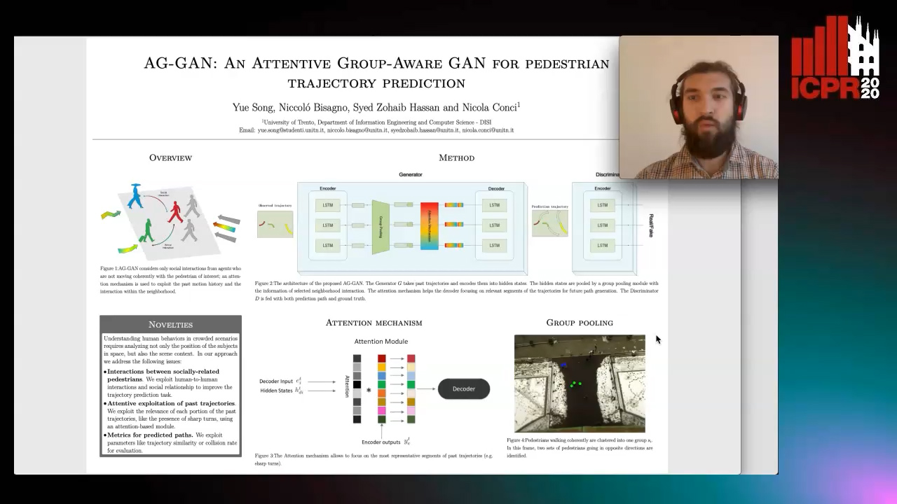
Auto-TLDR; An attentive group-aware GAN for motion prediction in crowded scenarios

Slides Poster Similar

Understanding human behaviors in crowded scenarios requires analyzing not only the position of the subjects in space, but also the scene context. Existing approaches mostly rely on the motion history of each pedestrian and model the interactions among people by considering the entire surrounding neighborhood. In our approach, we address the problem of motion prediction by applying coherent group clustering and a global attention mechanism on the LSTM-based Generative Adversarial Networks (GANs). The proposed model consists of an attentive group-aware GAN that observes the agents' past motion and predicts future paths, using (i) a group pooling module to model neighborhood interaction, and (ii) an attention module to specifically focus on hidden states. The experimental results demonstrate that our proposal outperforms state-of-the-art models on common benchmark datasets, and is able to generate socially-acceptable trajectories.

Low Dimensional State Representation Learning with Reward-Shaped Priors

Nicolò Botteghi, Ruben Obbink, Daan Geijs, Mannes Poel, Beril Sirmacek, Christoph Brune, Abeje Mersha, Stefano Stramigioli

Responsive image

Auto-TLDR; Unsupervised Learning for Unsupervised Reinforcement Learning in Robotics

Poster Similar

Reinforcement Learning has been able to solve many complicated robotics tasks without any need of feature engineering in an end-to-end fashion. However, learning the optimal policy directly from the sensory inputs, i.e the observations, often requires processing and storage of huge amount of data. In the context of robotics, the cost of data from real robotics hardware is usually very high, thus solutions that achieves high sample-efficiency are needed. We propose a method that aims at learning a mapping from the observations into a lower dimensional state space. This mapping is learned with unsupervised learning using loss functions shaped to incorporate prior knowledge of the environment and the task. Using the samples from the state space, the optimal policy is quickly and efficiently learned. We test the method on several mobile robot navigation tasks in simulation environment and also on a real robot.

What and How? Jointly Forecasting Human Action and Pose

Yanjun Zhu, Yanxia Zhang, Qiong Liu, Andreas Girgensohn

Responsive image

Auto-TLDR; Forecasting Human Actions and Motion Trajectories with Joint Action Classification and Pose Regression

Slides Poster Similar

Forecasting human actions and motion trajectories addresses the problem of predicting what a person is going to do next and how they will perform it. This is crucial in a wide range of applications such as assisted living and future co-robotic settings. We propose to simultaneously learn actions and action-related human motion dynamics, while existing works perform them independently. In this paper, we present a method to jointly forecast categories of human action and the pose of skeletal joints in the hope that the two tasks can help each other. As a result, our system can predict not only the future actions but also the motion trajectories that will result. To achieve this, we define a task of joint action classification and pose regression. We employ a sequence to sequence encoder-decoder model combined with multi-task learning to forecast future actions and poses progressively before the action happens. Experimental results on two public datasets, IkeaDB and OAD, demonstrate the effectiveness of the proposed method.

Image Sequence Based Cyclist Action Recognition Using Multi-Stream 3D Convolution

Stefan Zernetsch, Steven Schreck, Viktor Kress, Konrad Doll, Bernhard Sick

Responsive image

Auto-TLDR; 3D-ConvNet: A Multi-stream 3D Convolutional Neural Network for Detecting Cyclists in Real World Traffic Situations

Slides Poster Similar

In this article, we present an approach to detect basic movements of cyclists in real world traffic situations based on image sequences, optical flow (OF) sequences, and past positions using a multi-stream 3D convolutional neural network (3D-ConvNet) architecture. To resolve occlusions of cyclists by other traffic participants or road structures, we use a wide angle stereo camera system mounted at a heavily frequented public intersection. We created a large dataset consisting of 1,639 video sequences containing cyclists, recorded in real world traffic, resulting in over 1.1 million samples. Through modeling the cyclists' behavior by a state machine of basic cyclist movements, our approach takes every situation into account and is not limited to certain scenarios. We compare our method to an approach solely based on position sequences. Both methods are evaluated taking into account frame wise and scene wise classification results of basic movements, and detection times of basic movement transitions, where our approach outperforms the position based approach by producing more reliable detections with shorter detection times. Our code and parts of our dataset are made publicly available.

P2D: A Self-Supervised Method for Depth Estimation from Polarimetry

Marc Blanchon, Desire Sidibe, Olivier Morel, Ralph Seulin, Daniel Braun, Fabrice Meriaudeau

Responsive image

Auto-TLDR; Polarimetric Regularization for Monocular Depth Estimation

Slides Poster Similar

Monocular depth estimation is a recurring subject in the field of computer vision. Its ability to describe scenes via a depth map while reducing the constraints related to the formulation of perspective geometry tends to favor its use. However, despite the constant improvement of algorithms, most methods exploit only colorimetric information. Consequently, robustness to events to which the modality is not sensitive to, like specularity or transparency, is neglected. In response to this phenomenon, we propose using polarimetry as an input for a self-supervised monodepth network. Therefore, we propose exploiting polarization cues to encourage accurate reconstruction of scenes. Furthermore, we include a term of polarimetric regularization to state-of-the-art method to take specific advantage of the data. Our method is evaluated both qualitatively and quantitatively demonstrating that the contribution of this new information as well as an enhanced loss function improves depth estimation results, especially for specular areas.

Learning to Segment Dynamic Objects Using SLAM Outliers

Dupont Romain, Mohamed Tamaazousti, Hervé Le Borgne

Responsive image

Auto-TLDR; Automatic Segmentation of Dynamic Objects Using SLAM Outliers Using Consensus Inversion

Slides Poster Similar

We present a method to automatically learn to segment dynamic objects using SLAM outliers. It requires only one monocular sequence per dynamic object for training and consists in localizing dynamic objects using SLAM outliers, creating their masks, and using these masks to train a semantic segmentation network. We integrate the trained network in ORB-SLAM 2 and LDSO. At runtime we remove features on dynamic objects, making the SLAM unaffected by them. We also propose a new stereo dataset and new metrics to evaluate SLAM robustness. Our dataset includes consensus inversions, i.e., situations where the SLAM uses more features on dynamic objects that on the static background. Consensus inversions are challenging for SLAM as they may cause major SLAM failures. Our approach performs better than the State-of-the-Art on the TUM RGB-D dataset in monocular mode and on our dataset in both monocular and stereo modes.

Attention Based Coupled Framework for Road and Pothole Segmentation

Shaik Masihullah, Ritu Garg, Prerana Mukherjee, Anupama Ray

Responsive image

Auto-TLDR; Few Shot Learning for Road and Pothole Segmentation on KITTI and IDD

Slides Poster Similar

In this paper, we propose a novel attention based coupled framework for road and pothole segmentation. In many developing countries as well as in rural areas, the drivable areas are neither well-defined, nor well-maintained. Under such circumstances, an Advance Driver Assistant System (ADAS) is needed to assess the drivable area and alert about the potholes ahead to ensure vehicle safety. Moreover, this information can also be used in structured environments for assessment and maintenance of road health. We demonstrate few shot learning approach for pothole detection to leverage accuracy even with fewer training samples. We report the exhaustive experimental results for road segmentation on KITTI and IDD datasets. We also present pothole segmentation on IDD.

A Bayesian Approach to Reinforcement Learning of Vision-Based Vehicular Control

Zahra Gharaee, Karl Holmquist, Linbo He, Michael Felsberg

Responsive image

Auto-TLDR; Bayesian Reinforcement Learning for Autonomous Driving

Slides Poster Similar

In this paper, we present a state-of-the-art reinforcement learning method for autonomous driving. Our approach employs temporal difference learning in a Bayesian framework to learn vehicle control signals from sensor data. The agent has access to images from a forward facing camera, which are pre-processed to generate semantic segmentation maps. We trained our system using both ground truth and estimated semantic segmentation input. Based on our observations from a large set of experiments, we conclude that training the system on ground truth input data leads to better performance than training the system on estimated input even if estimated input is used for evaluation. The system is trained and evaluated in a realistic simulated urban environment using the CARLA simulator. The simulator also contains a benchmark that allows for comparing to other systems and methods. The required training time of the system is shown to be lower and the performance on the benchmark superior to competing approaches.

Total Estimation from RGB Video: On-Line Camera Self-Calibration, Non-Rigid Shape and Motion

Antonio Agudo

Responsive image

Auto-TLDR; Joint Auto-Calibration, Pose and 3D Reconstruction of a Non-rigid Object from an uncalibrated RGB Image Sequence

Slides Poster Similar

In this paper we present a sequential approach to jointly retrieve camera auto-calibration, camera pose and the 3D reconstruction of a non-rigid object from an uncalibrated RGB image sequence, without assuming any prior information about the shape structure, nor the need for a calibration pattern, nor the use of training data at all. To this end, we propose a Bayesian filtering approach based on a sum-of-Gaussians filter composed of a bank of extended Kalman filters (EKF). For every EKF, we make use of dynamic models to estimate its state vector, which later will be Gaussianly combined to achieve a global solution. To deal with deformable objects, we incorporate a mechanical model solved by using the finite element method. Thanks to these ingredients, the resulting method is both efficient and robust to several artifacts such as missing and noisy observations as well as sudden camera motions, while being available for a wide variety of objects and materials, including isometric and elastic shape deformations. Experimental validation is proposed in real experiments, showing its strengths with respect to competing approaches.

Force Banner for the Recognition of Spatial Relations

Robin Deléarde, Camille Kurtz, Laurent Wendling, Philippe Dejean

Responsive image

Auto-TLDR; Spatial Relation Recognition using Force Banners

Slides Similar

Studying the spatial organization of objects in images is fundamental to increase both the understanding of the sensed scene and the accuracy of the perceived similarity between images. This often leads to the problem of spatial relation recognition: given two objects depicted in an image, what is their spatial relation? In this article, we consider this as a classification problem. Instead of considering directly the original image space (or imaging features) to predict the spatial relation, we propose a novel intermediate representation (called Force Banner) modeling rich spatial information between pairs of objects composing a scene. Such a representation captures the relative position between objects using a panel of forces (attraction and repulsion), that take into account the structural shapes of the objects and their distance in a directional fashion. Force Banners are used to feed a classical 2D Convolutional Neural Network (CNN) for the recognition of spatial relations, benefiting from pre-trained models and fine-tuning. Experimental results obtained on a dataset of images with various shapes highlight the interest of this approach, and in particular its benefit to describe spatial information.

Switching Dynamical Systems with Deep Neural Networks

Cesar Ali Ojeda Marin, Kostadin Cvejoski, Bogdan Georgiev, Ramses J. Sanchez

Responsive image

Auto-TLDR; Variational RNN for Switching Dynamics

Slides Poster Similar

The problem of uncovering different dynamicalregimes is of pivotal importance in time series analysis. Switchingdynamical systems provide a solution for modeling physical phe-nomena whose time series data exhibit different dynamical modes.In this work we propose a novel variational RNN model forswitching dynamics allowing for both non-Markovian and non-linear dynamical behavior between and within dynamic modes.Attention mechanisms are provided to inform the switchingdistribution. We evaluate our model on synthetic and empiricaldatasets of diverse nature and successfully uncover differentdynamical regimes and predict the switching dynamics.

Calibration and Absolute Pose Estimation of Trinocular Linear Camera Array for Smart City Applications

Martin Ahrnbom, Mikael Nilsson, Håkan Ardö, Kalle Åström, Oksana Yastremska-Kravchenko, Aliaksei Laureshyn

Responsive image

Auto-TLDR; Trinocular Linear Camera Array Calibration for Traffic Surveillance Applications

Slides Poster Similar

A method for calibrating a Trinocular Linear Camera Array (TLCA) for traffic surveillance applications, such as towards smart cities, is presented. A TLCA-specific parametrization guarantees that the calibration finds a model where all the cameras are on a straight line. The method uses both a chequerboard close to the camera, as well as measured 3D points far from the camera: points measured in world coordinates, as well as their corresponding 2D points found manually in the images. Superior calibration accuracy can be obtained compared to standard methods using only a single data source, largely due to the use of chequerboards, while the line constraint in the parametrization allows for joint rectification. The improved triangulation accuracy, from 8-12 cm to around 6 cm when calibrating with 30-50 points in our experiment, allowing better road user analysis. The method is demonstrated by a proof-of-concept application where a point cloud is generated from multiple disparity maps, visualizing road user detections in 3D.

Learning to Take Directions One Step at a Time

Qiyang Hu, Adrian Wälchli, Tiziano Portenier, Matthias Zwicker, Paolo Favaro

Responsive image

Auto-TLDR; Generating a Sequence of Motion Strokes from a Single Image

Slides Poster Similar

We present a method to generate a video sequence given a single image. Because items in an image can be animated in arbitrarily many different ways, we introduce as control signal a sequence of motion strokes. Such control signal can be automatically transferred from other videos, e.g., via bounding box tracking. Each motion stroke provides the direction to the moving object in the input image and we aim to train a network to generate an animation following a sequence of such directions. To address this task we design a novel recurrent architecture, which can be trained easily and effectively thanks to an explicit separation of past, future and current states. As we demonstrate in the experiments, our proposed architecture is capable of generating an arbitrary number of frames from a single image and a sequence of motion strokes. Key components of our architecture are an autoencoding constraint to ensure consistency with the past and a generative adversarial scheme to ensure that images look realistic and are temporally smooth. We demonstrate the effectiveness of our approach on the MNIST, KTH, Human3.6M, Push and Weizmann datasets.

AerialMPTNet: Multi-Pedestrian Tracking in Aerial Imagery Using Temporal and Graphical Features

Maximilian Kraus, Seyed Majid Azimi, Emec Ercelik, Reza Bahmanyar, Peter Reinartz, Alois Knoll

Responsive image

Auto-TLDR; AerialMPTNet: A novel approach for multi-pedestrian tracking in geo-referenced aerial imagery by fusing appearance features

Slides Poster Similar

Multi-pedestrian tracking in aerial imagery has several applications such as large-scale event monitoring, disaster management, search-and-rescue missions, and as input into predictive crowd dynamic models. Due to the challenges such as the large number and the tiny size of the pedestrians (e.g., 4 x 4 pixels) with their similar appearances as well as different scales and atmospheric conditions of the images with their extremely low frame rates (e.g., 2 fps), current state-of-the-art algorithms including the deep learning-based ones are unable to perform well. In this paper, we propose AerialMPTNet, a novel approach for multi-pedestrian tracking in geo-referenced aerial imagery by fusing appearance features from a Siamese Neural Network, movement predictions from a Long Short-Term Memory, and pedestrian interconnections from a GraphCNN. In addition, to address the lack of diverse aerial multi-pedestrian tracking datasets, we introduce the Aerial Multi-Pedestrian Tracking (AerialMPT) dataset consisting of 307 frames and 44,740 pedestrians annotated. To the best of our knowledge, AerialMPT is the largest and most diverse dataset to this date and will be released publicly. We evaluate AerialMPTNet on AerialMPT and KIT AIS, and benchmark with several state-of-the-art tracking methods. Results indicate that AerialMPTNet significantly outperforms other methods on accuracy and time-efficiency.

Motion Segmentation with Pairwise Matches and Unknown Number of Motions

Federica Arrigoni, Tomas Pajdla, Luca Magri

Responsive image

Auto-TLDR; Motion Segmentation using Multi-Modelfitting andpermutation synchronization

Slides Poster Similar

In this paper we address motion segmentation, that is the problem of clustering points in multiple images according to a number of moving objects. Two-frame correspondences are assumed as input without prior knowledge about trajectories. Our method is based on principles from ''multi-model fitting'' and ''permutation synchronization'', and - differently from previous techniques working under the same assumptions - it can handle an unknown number of motions. The proposed approach is validated on standard datasets, showing that it can correctly estimate the number of motions while maintaining comparable or better accuracy than the state of the art.

Visual Prediction of Driver Behavior in Shared Road Areas

Peter Gawronski, Darius Burschka

Responsive image

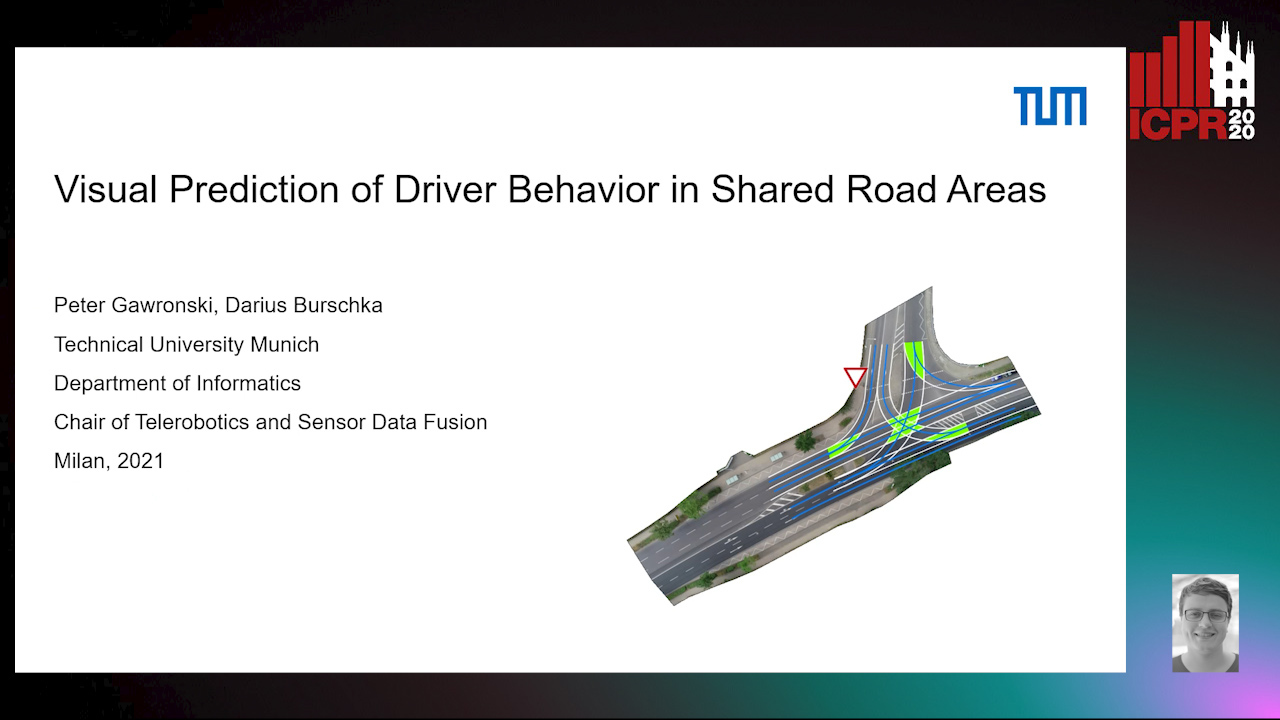
Auto-TLDR; Predicting Vehicle Behavior in Shared Road Segment Intersections Using Topological Knowledge

Slides Poster Similar

We propose a framework to analyze and predict vehicles behavior within shared road segments like intersections or at narrow passages. The system first identifies critical interaction regions based on topological knowledge. It then checks possible colliding trajectories from the current state of vehicles in the scene, defined by overlapping occupation times in road segments. For each possible interaction area, it analyzes the behavioral profile of both vehicles. Depending on right of way and (unpredictable) behavior parameters, different outcomes are expected and will be tested against input. The interaction between vehicles is analyzed over a short time horizon based on an initial action from one vehicle and the reaction by the other. The vehicle to yield most often performs the first action and the response of the opponent vehicle is measured after a reaction time. The observed reaction is classified by attention, if there was a reaction at all, and the collaboration of the opponent vehicle, whether it helps to resolve the situation or hinders it. The output is a classification of behavior of involved vehicles in terms of active participation in the interaction and assertiveness of driving style in terms of collaborative or disruptive behavior. The additional knowledge is used to refine the prediction of intention and outcome of a scene, which is then compared to the current status to catch unexpected behavior. The applicability of the concept and ideas of the approach is validated on scenarios from the recent Intersection Drone (inD) data set.

Temporal Pulses Driven Spiking Neural Network for Time and Power Efficient Object Recognition in Autonomous Driving

Wei Wang, Shibo Zhou, Jingxi Li, Xiaohua Li, Junsong Yuan, Zhanpeng Jin

Responsive image

Auto-TLDR; Spiking Neural Network for Real-Time Object Recognition on Temporal LiDAR Pulses

Slides Poster Similar

Accurate real-time object recognition from sensory data has long been a crucial and challenging task for autonomous driving. Even though deep neural networks (DNNs) have been widely applied in this area, their considerable processing latency, power consumption as well as computational complexity have been challenging issues for real-time autonomous driving applications. In this paper, we propose an approach to address the real-time object recognition problem utilizing spiking neural networks (SNNs). The proposed SNN model works directly with raw temporal LiDAR pulses without the pulse-to-point cloud preprocessing procedure, which can significantly reduce delay and power consumption. Being evaluated on various datasets derived from LiDAR and dynamic vision sensor (DVS), including Sim LiDAR, KITTI, and DVS-barrel, our proposed model has shown remarkable time and power efficiency, while achieving comparable recognition performance as the state-of-the-art methods. This paper highlights the SNN's great potentials in autonomous driving and related applications. To the best of our knowledge, this is the first attempt to use SNN to directly perform time and energy efficient object recognition on temporal LiDAR pulses in the setting of autonomous driving.

Future Urban Scenes Generation through Vehicles Synthesis

Alessandro Simoni, Luca Bergamini, Andrea Palazzi, Simone Calderara, Rita Cucchiara

Responsive image

Auto-TLDR; Predicting the Future of an Urban Scene with a Novel View Synthesis Paradigm

Slides Poster Similar

In this work we propose a deep learning pipeline to predict the visual future appearance of an urban scene. Despite recent advances, generating the entire scene in an end-to-end fashion is still far from being achieved. Instead, here we follow a two stages approach, where interpretable information is included in the loop and each actor is modelled independently. We leverage a per-object novel view synthesis paradigm; i.e. generating a synthetic representation of an object undergoing a geometrical roto-translation in the 3D space. Our model can be easily conditioned with constraints (e.g. input trajectories) provided by state-of-the-art tracking methods or by the user itself. This allows us to generate a set of diverse realistic futures starting from the same input in a multi-modal fashion. We visually and quantitatively show the superiority of this approach over traditional end-to-end scene-generation methods on CityFlow, a challenging real world dataset.

Edge-Aware Graph Attention Network for Ratio of Edge-User Estimation in Mobile Networks

Jiehui Deng, Sheng Wan, Xiang Wang, Enmei Tu, Xiaolin Huang, Jie Yang, Chen Gong

Responsive image

Auto-TLDR; EAGAT: Edge-Aware Graph Attention Network for Automatic REU Estimation in Mobile Networks

Slides Poster Similar

Estimating the Ratio of Edge-Users (REU) is an important issue in mobile networks, as it helps the subsequent adjustment of loads in different cells. However, existing approaches usually determine the REU manually, which are experience-dependent and labor-intensive, and thus the estimated REU might be imprecise. Considering the inherited graph structure of mobile networks, in this paper, we utilize a graph-based deep learning method for automatic REU estimation, where the practical cells are deemed as nodes and the load switchings among them constitute edges. Concretely, Graph Attention Network (GAT) is employed as the backbone of our method due to its impressive generalizability in dealing with networked data. Nevertheless, conventional GAT cannot make full use of the information in mobile networks, since it only incorporates node features to infer the pairwise importance and conduct graph convolutions, while the edge features that are actually critical in our problem are disregarded. To accommodate this issue, we propose an Edge-Aware Graph Attention Network (EAGAT), which is able to fuse the node features and edge features for REU estimation. Extensive experimental results on two real-world mobile network datasets demonstrate the superiority of our EAGAT approach to several state-of-the-art methods.

Derivation of Geometrically and Semantically Annotated UAV Datasets at Large Scales from 3D City Models

Sidi Wu, Lukas Liebel, Marco Körner

Responsive image

Auto-TLDR; Large-Scale Dataset of Synthetic UAV Imagery for Geometric and Semantic Annotation

Slides Poster Similar

While in high demand for the development of deep learning approaches, extensive datasets of annotated UAV imagery are still scarce today. Manual annotation, however, is time-consuming and, thus, has limited the potential for creating large-scale datasets. We tackle this challenge by presenting a procedure for the automatic creation of simulated UAV image sequences in urban areas and pixel-level annotations from publicly available data sources. We synthesize photo-realistic UAV imagery from Goole Earth Studio and derive annotations from an open CityGML model that not only provides geometric but also semantic information. The first dataset we exemplarily created using our approach contains 144000 images of Berlin, Germany, with four types of annotations, namely semantic labels as well as depth, surface normals, and edge maps. In the future, a complete pipeline regarding all the technical problems will be provided, together with more accurate models to refine some of the empirical settings currently, to automatically generate a large-scale dataset with reliable ground-truth annotations over the whole city of Berlin. The dataset, as well as the source code, will be published by then. Different methods will also be facilitated to test the usability of the dataset. We believe our dataset can be used for, and not limited to, tasks like pose estimation, geo-localization, monocular depth estimation, edge detection, building/surface classification, and plane segmentation. A potential research pipeline for geo-localization based on the synthetic dataset is provided.

Constructing Geographic and Long-term Temporal Graph for Traffic Forecasting

Yiwen Sun, Yulu Wang, Kun Fu, Zheng Wang, Changshui Zhang, Jieping Ye

Responsive image

Auto-TLDR; GLT-GCRNN: Geographic and Long-term Temporal Graph Convolutional Recurrent Neural Network for Traffic Forecasting

Slides Poster Similar

Traffic forecasting influences various intelligent transportation system (ITS) services and is of great significance for user experience as well as urban traffic control. It is challenging due to the fact that the road network contains complex and time-varying spatial-temporal dependencies. Recently, deep learning based methods have achieved promising results by adopting graph convolutional network (GCN) to extract the spatial correlations and recurrent neural network (RNN) to capture the temporal dependencies. However, the existing methods often construct the graph only based on road network connectivity, which limits the interaction between roads. In this work, we propose Geographic and Long-term Temporal Graph Convolutional Recurrent Neural Network (GLT-GCRNN), a novel framework for traffic forecasting that learns the rich interactions between roads sharing similar geographic or long-term temporal patterns. Extensive experiments on a real-world traffic state dataset validate the effectiveness of our method by showing that GLT-GCRNN outperforms the state-of-the-art methods in terms of different metrics.

TreeRNN: Topology-Preserving Deep Graph Embedding and Learning

Yecheng Lyu, Ming Li, Xinming Huang, Ulkuhan Guler, Patrick Schaumont, Ziming Zhang

Responsive image

Auto-TLDR; TreeRNN: Recurrent Neural Network for General Graph Classification

Slides Poster Similar

General graphs are difficult for learning due to their irregular structures. Existing works employ message passing along graph edges to extract local patterns using customized graph kernels, but few of them are effective for the integration of such local patterns into global features. In contrast, in this paper we study the methods to transfer the graphs into trees so that explicit orders are learned to direct the feature integration from local to global. To this end, we apply the breadth first search (BFS) to construct trees from the graphs, which adds direction to the graph edges from the center node to the peripheral nodes. In addition, we proposed a novel projection scheme that transfer the trees to image representations, which is suitable for conventional convolution neural networks (CNNs) and recurrent neural networks (RNNs). To best learn the patterns from the graph-tree-images, we propose TreeRNN, a 2D RNN architecture that recurrently integrates the image pixels by rows and columns to help classify the graph categories. We evaluate the proposed method on several graph classification datasets, and manage to demonstrate comparable accuracy with the state-of-the-art on MUTAG, PTC-MR and NCI1 datasets.

Street-Map Based Validation of Semantic Segmentation in Autonomous Driving

Laura Von Rueden, Tim Wirtz, Fabian Hueger, Jan David Schneider, Nico Piatkowski, Christian Bauckhage

Responsive image

Auto-TLDR; Semantic Segmentation Mask Validation Using A-priori Knowledge from Street Maps

Slides Poster Similar

Artificial intelligence for autonomous driving must meet strict requirements on safety and robustness, which motivates the thorough validation of learned models. However, current validation approaches mostly require ground truth data and are thus both cost-intensive and limited in their applicability. We propose to overcome these limitations by a model agnostic validation using a-priori knowledge from street maps. In particular, we show how to validate semantic segmentation masks and demonstrate the potential of our approach using OpenStreetMap. We introduce validation metrics that indicate false positive or negative road segments. Besides the validation approach, we present a method to correct the vehicle's GPS position so that a more accurate localization can be used for the street map based validation. Lastly, we present quantitative results on the Cityscapes dataset indicating that our validation approach can indeed uncover errors in semantic segmentation masks.