Localization of Unmanned Aerial Vehicles in Corridor Environments Using Deep Learning

Ram Padhy, Shahzad Ahmad, Sachin Verma, Sambit Bakshi, Pankaj Kumar Sa

Responsive image

Auto-TLDR; A monocular vision assisted localization algorithm for indoor corridor environments

Slides Poster

We propose a monocular vision assisted localization algorithm, that will help a UAV navigate safely in indoor corridor environments. Always, the aim is to navigate the UAV through a corridor in the forward direction by keeping it at the center with no orientation either to the left or right side. The algorithm makes use of the RGB image, captured from the UAV front camera, and passes it through a trained Deep Neural Network (DNN) to predict the position of the UAV as either on the left or center or right side of the corridor. Depending upon the divergence of the UAV with respect to an imaginary central line, known as the central bisector line (CBL) of the corridor, a suitable command is generated to bring the UAV to the center. When the UAV is at the center of the corridor, a new image is passed through another trained DNN to predict the orientation of the UAV with respect to the CBL of the corridor. If the UAV is either left or right tilted, an appropriate command is generated to rectify the orientation. We also propose a new corridor dataset, named UAVCorV1, which contains images as captured by the UAV front camera when the UAV is at all possible locations of a variety of corridors. An exhaustive set of experiments in different corridors reveal the efficacy of the proposed algorithm.

Similar papers

Holistic Grid Fusion Based Stop Line Estimation

Runsheng Xu, Faezeh Tafazzoli, Li Zhang, Timo Rehfeld, Gunther Krehl, Arunava Seal

Responsive image

Auto-TLDR; Fused Multi-Sensory Data for Stop Lines Detection in Intersection Scenarios

Slides Similar

Intersection scenarios provide the most complex traffic situations in Autonomous Driving and Driving Assistance Systems. Knowing where to stop in advance in an intersection is an essential parameter in controlling the longitudinal velocity of the vehicle. Most of the existing methods in literature solely use cameras to detect stop lines, which is typically not sufficient in terms of detection range. To address this issue, we propose a method that takes advantage of fused multi-sensory data including stereo camera and lidar as input and utilizes a carefully designed convolutional neural network architecture to detect stop lines. Our experiments show that the proposed approach can improve detection range compared to camera data alone, works under heavy occlusion without observing the ground markings explicitly, is able to predict stop lines for all lanes and allows detection at a distance up to 50 meters.

Unconstrained Vision Guided UAV Based Safe Helicopter Landing

Arindam Sikdar, Abhimanyu Sahu, Debajit Sen, Rohit Mahajan, Ananda Chowdhury

Responsive image

Auto-TLDR; Autonomous Helicopter Landing in Hazardous Environments from Unmanned Aerial Images Using Constrained Graph Clustering

Slides Poster Similar

In this paper, we have addressed the problem of automated detection of safe zone(s) for helicopter landing in hazardous environments from images captured by an Unmanned Aerial Vehicle (UAV). The unconstrained motion of the image capturing drone (the UAV in our case) makes the problem further difficult. The solution pipeline consists of natural landmark detection and tracking, stereo-pair generation using constrained graph clustering, digital terrain map construction and safe landing zone detection. The main methodological contribution lies in mathematically formulating epipolar constraint and then using it in a Minimum Spanning Tree (MST) based graph clustering approach. We have also made publicly available AHL (Autonomous Helicopter Landing) dataset, a new aerial video dataset captured by a drone, with annotated ground-truths. Experimental comparisons with other competing clustering methods i) in terms of Dunn Index and Davies Bouldin Index as well as ii) for frame-level safe zone detection in terms of F-measure and confusion matrix clearly demonstrate the effectiveness of the proposed formulation.

RISEdb: A Novel Indoor Localization Dataset

Carlos Sanchez Belenguer, Erik Wolfart, Álvaro Casado Coscollá, Vitor Sequeira

Responsive image

Auto-TLDR; Indoor Localization Using LiDAR SLAM and Smartphones: A Benchmarking Dataset

Slides Poster Similar

In this paper we introduce a novel public dataset for developing and benchmarking indoor localization systems. We have selected and 3D mapped a set of representative indoor environments including a large office building, a conference room, a workshop, an exhibition area and a restaurant. Our acquisition pipeline is based on a portable LiDAR SLAM backpack to map the buildings and to accurately track the pose of the user as it moves freely inside them. We introduce the calibration procedures that enable us to acquire and geo-reference live data coming from different independent sensors rigidly attached to the backpack. This has allowed us to collect long sequences of spherical and stereo images, together with all the sensor readings coming from a consumer smartphone and locate them inside the map with centimetre accuracy. The dataset addresses many of the limitations of existing indoor localization datasets regarding the scale and diversity of the mapped buildings; the number of acquired sequences under varying conditions; the accuracy of the ground-truth trajectory; the availability of a detailed 3D model and the availability of different sensor types. It enables the benchmarking of existing and the development of new indoor localization approaches, in particular for deep learning based systems that require large amounts of labeled training data.

Benchmarking Cameras for OpenVSLAM Indoors

Kevin Chappellet, Guillaume Caron, Fumio Kanehiro, Ken Sakurada, Abderrahmane Kheddar

Responsive image

Auto-TLDR; OpenVSLAM: Benchmarking Camera Types for Visual Simultaneous Localization and Mapping

Slides Poster Similar

In this paper we benchmark different types of cameras and evaluate their performance in terms of reliable localization reliability and precision in Visual Simultaneous Localization and Mapping (vSLAM). Such benchmarking is merely found for visual odometry, but never for vSLAM. Existing studies usually compare several algorithms for a given camera. %This work is the first to handle the dual of the latter, i.e. comparing several cameras for a given SLAM algorithm. The evaluation methodology we propose is applied to the recent OpenVSLAM framework. The latter is versatile enough to natively deal with perspective, fisheye, 360 cameras in a monocular or stereoscopic setup, an in RGB or RGB-D modalities. Results in various sequences containing light variation and scenery modifications in the scene assess quantitatively the maximum localization rate for 360 vision. In the contrary, RGB-D vision shows the lowest localization rate, but highest precision when localization is possible. Stereo-fisheye trades-off with localization rates and precision between 360 vision and RGB-D vision. The dataset with ground truth will be made available in open access to allow evaluating other/future vSLAM algorithms with respect to these camera types.

Extending Single Beam Lidar to Full Resolution by Fusing with Single Image Depth Estimation

Yawen Lu, Yuxing Wang, Devarth Parikh, Guoyu Lu

Responsive image

Auto-TLDR; Self-supervised LIDAR for Low-Cost Depth Estimation

Slides Similar

Depth estimation is playing an important role in indoor and outdoor scene understanding, autonomous driving, augmented reality and many other tasks. Vehicles and robotics are able to use active illumination sensors such as LIDAR to receive high precision depth estimation. However, high-resolution Lidars are usually too expensive, which limits its massive production on various applications. Though single beam LIDAR enjoys the benefits of low cost, one beam depth sensing is not usually sufficient to perceive the surrounding environment in many scenarios. In this paper, we propose a learning-based framework to explore to replicate similar or even higher performance as costly LIDARs with our designed self-supervised network and a low-cost single-beam LIDAR. After the accurate calibration with a visible camera, the single beam LIDAR can adjust the scale uncertainty of the depth map estimated by the visible camera. The adjusted depth map enjoys the benefits of high resolution and sensing accuracy as high beam LIDAR and maintains low-cost as single beam LIDAR. Thus we can achieve similar sensing effect of high beam LIDAR with more than a 50-100 times cheaper price (e.g., \$80000 Velodyne HDL-64E LIDAR v.s. \$1000 SICK TIM-781 2D LIDAR and normal camera). The proposed approach is verified on our collected dataset and public dataset with superior depth-sensing performance.

Towards life-long mapping of dynamic environments using temporal persistence modeling

Georgios Tsamis, Ioannis Kostavelis, Dimitrios Giakoumis, Dimitrios Tzovaras

Responsive image

Auto-TLDR; Lifelong Mapping for Mobile Robot Navigation in Dynamic Environments

Slides Poster Similar

The contemporary SLAM mapping systems assume a static environment and build a map that is then used for mobile robot navigation disregarding the dynamic changes in this environment. The paper at hand presents a novel solution for the \emph{lifelong mapping} problem that continually updates a metric map represented as a 2D occupancy grid in large scale indoor environments with movable objects such as people, robots, objects etc. suitable for industrial applications. We formalize each cell's occupancy as a failure analysis problem and contribute temporal persistence modeling (TPM), an algorithm for probabilistic prediction of the time that a cell in an observed location is expected to be ``occupied" or ``empty" given sparse prior observations from a task specific mobile robot. Our work is evaluated in Gazebo simulation environment against the nominal occupancy of cells and the estimated obstacles persistence. We also show that robot navigation with lifelong mapping demands less re-plans and leads to more efficient navigation in highly dynamic environments.

Map-Based Temporally Consistent Geolocalization through Learning Motion Trajectories

Bing Zha, Alper Yilmaz

Responsive image

Auto-TLDR; Exploiting Motion Trajectories for Geolocalization of Object on Topological Map using Recurrent Neural Network

Slides Poster Similar

In this paper, we propose a novel trajectory learning method that exploits motion trajectories on topological map using recurrent neural network for temporally consistent geolocalization of object. Inspired by human's ability to both be aware of distance and direction of self-motion in navigation, our trajectory learning method learns a pattern representation of trajectories encoded as a sequence of distances and turning angles to assist self-localization. We pose the learning process as a conditional sequence prediction problem in which each output locates the object on a traversable edge in a map. Considering the prediction sequence ought to be topologically connected in the graph-structured map, we adopt two different hypotheses generation and elimination strategies to eliminate disconnected sequence prediction. We demonstrate our approach on the KITTI stereo visual odometry dataset which is a city-scale environment. The key benefits of our approach to geolocalization are that 1) we take advantage of powerful sequence modeling ability of recurrent neural network and its robustness to noisy input, 2) only require a map in the form of a graph and 3) simply use an affordable sensor that generates motion trajectory. The experiments show that the motion trajectories can be learned by training an recurrent neural network, and temporally consistent geolocation can be predicted with both of the proposed strategies.

AV-SLAM: Autonomous Vehicle SLAM with Gravity Direction Initialization

Kaan Yilmaz, Baris Suslu, Sohini Roychowdhury, L. Srikar Muppirisetty

Responsive image

Auto-TLDR; VI-SLAM with AGI: A combination of three SLAM algorithms for autonomous vehicles

Slides Poster Similar

Simultaneous localization and mapping (SLAM) algorithms that are aimed at autonomous vehicles (AVs) are required to utilize sensor redundancies specific to AVs and enable accurate, fast and repeatable estimations of pose and path trajectories. In this work, we present a combination of three SLAM algorithms that utilize a different subset of available sensors such as inertial measurement unit (IMU), a gray-scale mono-camera, and a Lidar. Also, we propose a novel acceleration-based gravity direction initialization (AGI) method for the visual-inertial SLAM algorithm. We analyze the SLAM algorithms and initialization methods for pose estimation accuracy, speed of convergence and repeatability on the KITTI odometry sequences. The proposed VI-SLAM with AGI method achieves relative pose errors less than 2\%, convergence in half a minute or less and convergence time variability less than 3s, which makes it preferable for AVs.

Object-Oriented Map Exploration and Construction Based on Auxiliary Task Aided DRL

Junzhe Xu, Jianhua Zhang, Shengyong Chen, Honghai Liu

Responsive image

Auto-TLDR; Auxiliary Task Aided Deep Reinforcement Learning for Environment Exploration by Autonomous Robots

Similar

Environment exploration by autonomous robots through deep reinforcement learning (DRL) based methods has attracted more and more attention. However, existing methods usually focus on robot navigation to single or multiple fixed goals, while ignoring the perception and construction of external environments. In this paper, we propose a novel environment exploration task based on DRL, which requires a robot fast and completely perceives all objects of interest, and reconstructs their poses in a global environment map, as much as the robot can do. To this end, we design an auxiliary task aided DRL model, which is integrated with the auxiliary object detection and 6-DoF pose estimation components. The outcome of auxiliary tasks can improve the learning speed and robustness of DRL, as well as the accuracy of object pose estimation. Comprehensive experimental results on the indoor simulation platform AI2-THOR have shown the effectiveness and robustness of our method.

P2D: A Self-Supervised Method for Depth Estimation from Polarimetry

Marc Blanchon, Desire Sidibe, Olivier Morel, Ralph Seulin, Daniel Braun, Fabrice Meriaudeau

Responsive image

Auto-TLDR; Polarimetric Regularization for Monocular Depth Estimation

Slides Poster Similar

Monocular depth estimation is a recurring subject in the field of computer vision. Its ability to describe scenes via a depth map while reducing the constraints related to the formulation of perspective geometry tends to favor its use. However, despite the constant improvement of algorithms, most methods exploit only colorimetric information. Consequently, robustness to events to which the modality is not sensitive to, like specularity or transparency, is neglected. In response to this phenomenon, we propose using polarimetry as an input for a self-supervised monodepth network. Therefore, we propose exploiting polarization cues to encourage accurate reconstruction of scenes. Furthermore, we include a term of polarimetric regularization to state-of-the-art method to take specific advantage of the data. Our method is evaluated both qualitatively and quantitatively demonstrating that the contribution of this new information as well as an enhanced loss function improves depth estimation results, especially for specular areas.

Real-Time End-To-End Lane ID Estimation Using Recurrent Networks

Ibrahim Halfaoui, Fahd Bouzaraa, Onay Urfalioglu

Responsive image

Auto-TLDR; Real-Time, Vision-Only Lane Identification Using Monocular Camera

Slides Poster Similar

Acquiring information about the road lane structure is a crucial step for autonomous navigation. To this end, several approaches tackle this task from different perspectives such as lane marking detection or semantic lane segmentation.However, to the best of our knowledge, there is yet no purely vision based end-to-end solution to answer the precise question: How to estimate the relative number or "ID" of the current driven lane within a multi-lane road or a highway? In this work, we propose a real-time, vision-only (i.e. monocular camera) solution to the problem based on a dual left-right convention. We interpret this task as a classification problem by limiting the maximum number of lane candidates to eight. Our approach is designed to meet low-complexity specifications and limited runtime requirements. It harnesses the temporal dimension inherent to the input sequences to improve upon high complexity state-of-the-art models. We achieve more than 95% accuracy on a challenging test set with extreme conditions and different routes.

Loop-closure detection by LiDAR scan re-identification

Jukka Peltomäki, Xingyang Ni, Jussi Puura, Joni-Kristian Kamarainen, Heikki Juhani Huttunen

Responsive image

Auto-TLDR; Loop-Closing Detection from LiDAR Scans Using Convolutional Neural Networks

Slides Poster Similar

In this work, loop-closure detection from LiDAR scans is defined as an image re-identification problem. Re-identification is performed by computing Euclidean distances of a query scan to a gallery set of previous scans. The distances are computed in a feature embedding space where the scans are mapped by a convolutional neural network (CNN). The network is trained using the triplet loss training strategy. In our experiments we compare different backbone networks, variants of the triplet loss and generic and LiDAR specific data augmentation techniques. With a realistic indoor dataset the best architecture obtains the mean average precision (mAP) above 90%.

Surface Material Dataset for Robotics Applications (SMDRA): A Dataset with Friction Coefficient and RGB-D for Surface Segmentation

Donghun Noh, Hyunwoo Nam, Min Sung Ahn, Hosik Chae, Sangjoon Lee, Kyle Gillespie, Dennis Hong

Responsive image

Auto-TLDR; A Surface Material Dataset for Robotics Applications

Slides Poster Similar

In this paper, we introduce the Surface Material Dataset for Robotics Applications (SMDRA), a collection of RGB color image, depth data, and pixel-wise friction coefficient data of 10 different materials for computer vision research specifically with robotics applications in mind that require physical contact between the robot and its environment such as robotic manipulators or walking robots. These selected surface materials are both easily accessible around our daily lives and cover a wide range of friction coefficients. Our dataset is unique in that while there is an abundance of RGB-D data due to the popularization of imaging sensors, additional pixel-wise aligned data of a different modality are not readily available. The depth data is collected by an active stereo camera which has shown promise on a variety of different robotic applications. In addition, this dataset is greatly expanded with friction coefficient data. Similarly to humans, this additional information can be helpful in ensuing proper decision making in tasks ranging from grasping orientation and strength to path determination in an unstructured environment. A newly developed friction measuring device was used to obtain this data. We verify that existing Convolutional Neural Network (CNN) architectures, the Fully Convolutional Network (FCN) and U-Net, can be trained on the SMDRA. This result demonstrates that the SMDRA can be utilized to train a neural network model for segmentation and these different modes are not just additional information, but valuable modes that researchers can incorporate and exploit when applying computer vision algorithms on robotic platforms.

Weight Estimation from an RGB-D Camera in Top-View Configuration

Marco Mameli, Marina Paolanti, Nicola Conci, Filippo Tessaro, Emanuele Frontoni, Primo Zingaretti

Responsive image

Auto-TLDR; Top-View Weight Estimation using Deep Neural Networks

Slides Poster Similar

The development of so-called soft-biometrics aims at providing information related to the physical and behavioural characteristics of a person. This paper focuses on bodyweight estimation based on the observation from a top-view RGB-D camera. In fact, the capability to estimate the weight of a person can be of help in many different applications, from health-related scenarios to business intelligence and retail analytics. To deal with this issue, a TVWE (Top-View Weight Estimation) framework is proposed with the aim of predicting the weight. The approach relies on the adoption of Deep Neural Networks (DNNs) that have been trained on depth data. Each network has also been modified in its top section to replace classification with prediction inference. The performance of five state-of-art DNNs has been compared, namely VGG16, ResNet, Inception, DenseNet and Efficient-Net. In addition, a convolutional auto-encoder has also been included for completeness. Considering the limited literature in this domain, the TVWE framework has been evaluated on a new publicly available dataset: “VRAI Weight estimation Dataset”, which also collects, for each subject, labels related to weight, gender, and height. The experimental results have demonstrated that the proposed methods are suitable for this task, bringing different and significant insights for the application of the solution in different domains.

Dynamic Resource-Aware Corner Detection for Bio-Inspired Vision Sensors

Sherif Abdelmonem Sayed Mohamed, Jawad Yasin, Mohammad-Hashem Haghbayan, Antonio Miele, Jukka Veikko Heikkonen, Hannu Tenhunen, Juha Plosila

Responsive image

Auto-TLDR; Three Layer Filtering-Harris Algorithm for Event-based Cameras in Real-Time

Slides Similar

Event-based cameras are vision devices that transmit only brightness changes with low latency and ultra-low power consumption. Such characteristics make event-based cameras attractive in the field of localization and object tracking in resource-constrained systems. Since the number of generated events in such cameras is huge, the selection and filtering of the incoming events are beneficial from both increasing the accuracy of the features and reducing the computational load. In this paper, we present an algorithm to detect asynchronous corners form a stream of events in real-time on embedded systems. The algorithm is called the Three Layer Filtering-Harris or TLF-Harris algorithm. The algorithm is based on an events' filtering strategy whose purpose is 1) to increase the accuracy by deliberately eliminating some incoming events, i.e., noise and 2) to improve the real-time performance of the system, i.e., preserving a constant throughput in terms of input events per second, by discarding unnecessary events with a limited accuracy loss. An approximation of the Harris algorithm, in turn, is used to exploit its high-quality detection capability with a low-complexity implementation to enable seamless real-time performance on embedded computing platforms. The proposed algorithm is capable of selecting the best corner candidate among neighbors and achieves an average execution time savings of 59 % compared with the conventional Harris score. Moreover, our approach outperforms the competing methods, such as eFAST, eHarris, and FA-Harris, in terms of real-time performance, and surpasses Arc* in terms of accuracy.

Polarimetric Image Augmentation

Marc Blanchon, Fabrice Meriaudeau, Olivier Morel, Ralph Seulin, Desire Sidibe

Responsive image

Auto-TLDR; Polarimetric Augmentation for Deep Learning in Robotics Applications

Poster Similar

This paper deals with new augmentation methods for an unconventional imaging modality sensitive to the physics of the observed scene called polarimetry. In nature, polarized light is obtained by reflection or scattering. Robotics applications in urban environments are subject to many obstacles that can be specular and therefore provide polarized light. These areas are prone to segmentation errors using standard modalities but could be solved using information carried by the polarized light. Deep Convolutional Neural Networks (DCNNs) have shown excellent segmentation results, but require a significant amount of data to achieve best performances. The lack of data is usually overcomed by using augmentation methods. However, unlike RGB images, polarization images are not only scalar (intensity) images and standard augmentation techniques cannot be applied straightforwardly. We propose enhancing deep learning models through a regularized augmentation procedure applied to polarimetric data in order to characterize scenes more effectively under challenging conditions. We subsequently observe an average of 18.1% improvement in IoU between not augmented and regularized training procedures on real world data.

Minimal Solvers for Indoor UAV Positioning

Marcus Valtonen Örnhag, Patrik Persson, Mårten Wadenbäck, Kalle Åström, Anders Heyden

Responsive image

Auto-TLDR; Relative Pose Solvers for Visual Indoor UAV Navigation

Slides Poster Similar

In this paper we consider a collection of relative pose problems which arise naturally in applications for visual indoor UAV navigation. We focus on cases where additional information from an onboard IMU is available and thus provides a partial extrinsic calibration through the gravitational vector. The solvers are designed for a partially calibrated camera, for a variety of realistic indoor scenarios, which makes it possible to navigate using images of the ground floor. Current state-of-the-art solvers use more general assumptions, such as using arbitrary planar structures; however, these solvers do not yield adequate reconstructions for real scenes, nor do they perform fast enough to be incorporated in real-time systems. We show that the proposed solvers enjoy better numerical stability, are faster, and require fewer point correspondences, compared to state-of-the-art solvers. These properties are vital components for robust navigation in real-time systems, and we demonstrate on both synthetic and real data that our method outperforms other methods, and yields superior motion estimation.

OmniFlowNet: A Perspective Neural Network Adaptation for Optical Flow Estimation in Omnidirectional Images

Charles-Olivier Artizzu, Haozhou Zhang, Guillaume Allibert, Cédric Demonceaux

Responsive image

Auto-TLDR; OmniFlowNet: A Convolutional Neural Network for Omnidirectional Optical Flow Estimation

Slides Poster Similar

Spherical cameras and the latest image processing techniques open up new horizons. In particular, methods based on Convolutional Neural Networks (CNNs) now give excellent results for optical flow estimation on perspective images. However, these approaches are highly dependent on their architectures and training datasets. This paper proposes to benefit from years of improvement in perspective images optical flow estimation and to apply it to omnidirectional ones without training on new datasets. Our network, OmniFlowNet, is built on a CNN specialized in perspective images. Its convolution operation is adapted to be consistent with the equirectangular projection. Tested on spherical datasets created with Blender and several equirectangular videos realized from real indoor and outdoor scenes, OmniFlowNet shows better performance than its original network.

On Embodied Visual Navigation in Real Environments through Habitat

Marco Rosano, Antonino Furnari, Luigi Gulino, Giovanni Maria Farinella

Responsive image

Auto-TLDR; Learning Navigation Policies on Real World Observations using Real World Images and Sensor and Actuation Noise

Slides Poster Similar

Visual navigation models based on deep learning can learn effective policies when trained on large amounts of visual observations through reinforcement learning. Unfortunately, collecting the required experience deploying a robotic platform in the real world is expensive and time-consuming. To deal with this limitation, several simulation platforms have been proposed in order to train visual navigation policies on virtual environments efficiently. Despite the advantages they offer, simulators present a limited realism in terms of appearance and physical dynamics, leading to navigation policies that do not generalize in the real world. In this paper, we propose a tool based on the Habitat simulator which exploits real world images of the environment, together with sensor and actuator noise models, to produce more realistic navigation episodes. We perform a range of experiments using virtual, real and images transformed with a simple domain adaptation approach. We also assess the impact of sensor and actuation noise on the navigation performance and investigate whether they allow to learn more robust navigation policies. We show that our tool can effectively help to train and evaluate navigation policies on real world observations without running navigation episodes in the real world.

NetCalib: A Novel Approach for LiDAR-Camera Auto-Calibration Based on Deep Learning

Shan Wu, Amnir Hadachi, Damien Vivet, Yadu Prabhakar

Responsive image

Auto-TLDR; Automatic Calibration of LiDAR and Cameras using Deep Neural Network

Slides Poster Similar

A fusion of LiDAR and cameras have been widely used in many robotics applications such as classification, segmentation, object detection, and autonomous driving. It is essential that the LiDAR sensor can measure distances accurately, which is a good complement to the cameras. Hence, calibrating sensors before deployment is a mandatory step. The conventional methods include checkerboards, specific patterns, or human labeling, which is trivial and human-labor extensive if we do the same calibration process every time. The main propose of this research work is to build a deep neural network that is capable of automatically finding the geometric transformation between LiDAR and cameras. The results show that our model manages to find the transformations from randomly sampled artificial errors. Besides, our work is open-sourced for the community to fully utilize the advances of the methodology for developing more the approach, initiating collaboration, and innovation in the topic.

Improving Robotic Grasping on Monocular Images Via Multi-Task Learning and Positional Loss

William Prew, Toby Breckon, Magnus Bordewich, Ulrik Beierholm

Responsive image

Auto-TLDR; Improving grasping performance from monocularcolour images in an end-to-end CNN architecture with multi-task learning

Slides Poster Similar

In this paper we introduce two methods of improv-ing real-time objecting grasping performance from monocularcolour images in an end-to-end CNN architecture. The first isthe addition of an auxiliary task during model training (multi-task learning). Our multi-task CNN model improves graspingperformance from a baseline average of 72.04% to 78.14% onthe large Jacquard grasping dataset when performing a supple-mentary depth reconstruction task. The second is introducinga positional loss function that emphasises loss per pixel forsecondary parameters (gripper angle and width) only on points ofan object where a successful grasp can take place. This increasesperformance from a baseline average of 72.04% to 78.92% aswell as reducing the number of training epochs required. Thesemethods can be also performed in tandem resulting in a furtherperformance increase to 79.12%, while maintaining sufficientinference speed to enable processing at 50FPS

Real-Time Monocular Depth Estimation with Extremely Light-Weight Neural Network

Mian Jhong Chiu, Wei-Chen Chiu, Hua-Tsung Chen, Jen-Hui Chuang

Responsive image

Auto-TLDR; Real-Time Light-Weight Depth Prediction for Obstacle Avoidance and Environment Sensing with Deep Learning-based CNN

Slides Poster Similar

Obstacle avoidance and environment sensing are crucial applications in autonomous driving and robotics. Among all types of sensors, RGB camera is widely used in these applications as it can offer rich visual contents with relatively low-cost, and using a single image to perform depth estimation has become one of the main focuses in resent research works. However, prior works usually rely on highly complicated computation and power-consuming GPU to achieve such task; therefore, we focus on developing a real-time light-weight system for depth prediction in this paper. Based on the well-known encoder-decoder architecture, we propose a supervised learning-based CNN with detachable decoders that produce depth predictions with different scales. We also formulate a novel log-depth loss function that computes the difference of predicted depth map and ground truth depth map in log space, so as to increase the prediction accuracy for nearby locations. To train our model efficiently, we generate depth map and semantic segmentation with complex teacher models. Via a series of ablation studies and experiments, it is validated that our model can efficiently performs real-time depth prediction with only 0.32M parameters, with the best trained model outperforms previous works on KITTI dataset for various evaluation matrices.

Multiple Future Prediction Leveraging Synthetic Trajectories

Lorenzo Berlincioni, Federico Becattini, Lorenzo Seidenari, Alberto Del Bimbo

Responsive image

Auto-TLDR; Synthetic Trajectory Prediction using Markov Chains

Slides Poster Similar

Trajectory prediction is an important task, especially in autonomous driving. The ability to forecast the position of other moving agents can yield to an effective planning, ensuring safety for the autonomous vehicle as well for the observed entities. In this work we propose a data driven approach based on Markov Chains to generate synthetic trajectories, which are useful for training a multiple future trajectory predictor. The advantages are twofold: on the one hand synthetic samples can be used to augment existing datasets and train more effective predictors; on the other hand, it allows to generate samples with multiple ground truths, corresponding to diverse equally likely outcomes of the observed trajectory. We define a trajectory prediction model and a loss that explicitly address the multimodality of the problem and we show that combining synthetic and real data leads to prediction improvements, obtaining state of the art results.

Real-Time Drone Detection and Tracking with Visible, Thermal and Acoustic Sensors

Fredrik Svanström, Cristofer Englund, Fernando Alonso-Fernandez

Responsive image

Auto-TLDR; Automatic multi-sensor drone detection using sensor fusion

Slides Poster Similar

This paper explores the process of designing an automatic multi-sensor drone detection system. Besides the common video and audio sensors, the system also includes a thermal infrared camera, which is shown to be a feasible solution to the drone detection task. Even with slightly lower resolution, the performance is just as good as a camera in visible range. The detector performance as a function of the sensor-to-target distance is also investigated. In addition, using sensor fusion, the system is made more robust than the individual sensors, helping to reduce false detections. To counteract the lack of public datasets, a novel video dataset containing 650 annotated infrared and visible videos of drones, birds, airplanes and helicopters is also presented. The database is complemented with an audio dataset of the classes drones, helicopters and background noise.

Multimodal End-To-End Learning for Autonomous Steering in Adverse Road and Weather Conditions

Jyri Sakari Maanpää, Josef Taher, Petri Manninen, Leo Pakola, Iaroslav Melekhov, Juha Hyyppä

Responsive image

Auto-TLDR; End-to-End Learning for Autonomous Steering in Adverse Road and Weather Conditions with Lidar Data

Slides Poster Similar

Autonomous driving is challenging in adverse road and weather conditions in which there might not be lane lines, the road might be covered in snow and the visibility might be poor. We extend the previous work on end-to-end learning for autonomous steering to operate in these adverse real-life conditions with multimodal data. We collected 28 hours of driving data in several road and weather conditions and trained convolutional neural networks to predict the car steering wheel angle from front-facing color camera images and lidar range and reflectance data. We compared the CNN model performances based on the different modalities and our results show that the lidar modality improves the performances of different multimodal sensor-fusion models. We also performed on-road tests with different models and they support this observation.

Vehicle Lane Merge Visual Benchmark

Kai Cordes, Hellward Broszio

Responsive image

Auto-TLDR; A Benchmark for Automated Cooperative Maneuvering Using Multi-view Video Streams and Ground Truth Vehicle Description

Slides Poster Similar

Automated driving is regarded as the most promising technology for improving road safety in the future. In this context, connected vehicles have an important role regarding their ability to perform cooperative maneuvers for challenging traffic situations. We propose a benchmark for automated cooperative maneuvers. The targeted cooperative maneuver is the vehicle lane merge where a vehicle on the acceleration lane merges into the traffic of a motorway. The benchmark enables the evaluation of vehicle localization approaches as well as the study of cooperative maneuvers. It consists of temporally synchronized multi-view video streams, highly accurate camera calibration, and ground truth vehicle descriptions, including position, heading, speed, and shape. For benchmark generation, the lane merge maneuver is performed by human drivers on a test track, resulting in 120 lane merge data sets with various traffic situations and video recording conditions.

Calibration and Absolute Pose Estimation of Trinocular Linear Camera Array for Smart City Applications

Martin Ahrnbom, Mikael Nilsson, Håkan Ardö, Kalle Åström, Oksana Yastremska-Kravchenko, Aliaksei Laureshyn

Responsive image

Auto-TLDR; Trinocular Linear Camera Array Calibration for Traffic Surveillance Applications

Slides Poster Similar

A method for calibrating a Trinocular Linear Camera Array (TLCA) for traffic surveillance applications, such as towards smart cities, is presented. A TLCA-specific parametrization guarantees that the calibration finds a model where all the cameras are on a straight line. The method uses both a chequerboard close to the camera, as well as measured 3D points far from the camera: points measured in world coordinates, as well as their corresponding 2D points found manually in the images. Superior calibration accuracy can be obtained compared to standard methods using only a single data source, largely due to the use of chequerboards, while the line constraint in the parametrization allows for joint rectification. The improved triangulation accuracy, from 8-12 cm to around 6 cm when calibrating with 30-50 points in our experiment, allowing better road user analysis. The method is demonstrated by a proof-of-concept application where a point cloud is generated from multiple disparity maps, visualizing road user detections in 3D.

Partially Supervised Multi-Task Network for Single-View Dietary Assessment

Ya Lu, Thomai Stathopoulou, Stavroula Mougiakakou

Responsive image

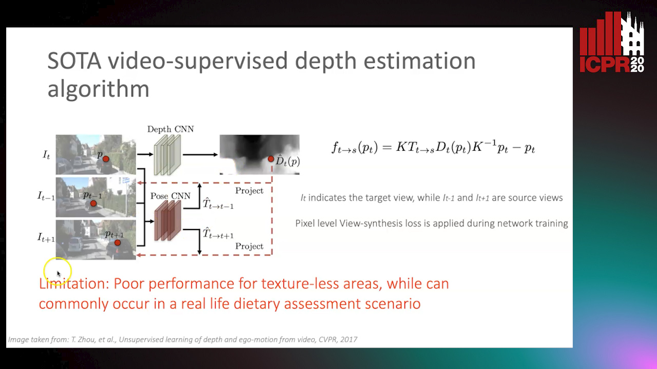
Auto-TLDR; Food Volume Estimation from a Single Food Image via Geometric Understanding and Semantic Prediction

Slides Poster Similar

Food volume estimation is an essential step in the pipeline of dietary assessment and demands the precise depth estimation of the food surface and table plane. Existing methods based on computer vision require either multi-image input or additional depth maps, reducing convenience of implementation and practical significance. Despite the recent advances in unsupervised depth estimation from a single image, the achieved performance in the case of large texture-less areas needs to be improved. In this paper, we propose a network architecture that jointly performs geometric understanding (i.e., depth prediction and 3D plane estimation) and semantic prediction on a single food image, enabling a robust and accurate food volume estimation regardless of the texture characteristics of the target plane. For the training of the network, only monocular videos with semantic ground truth are required, while the depth map and 3D plane ground truth are no longer needed. Experimental results on two separate food image databases demonstrate that our method performs robustly on texture-less scenarios and is superior to unsupervised networks and structure from motion based approaches, while it achieves comparable performance to fully-supervised methods.

Derivation of Geometrically and Semantically Annotated UAV Datasets at Large Scales from 3D City Models

Sidi Wu, Lukas Liebel, Marco Körner

Responsive image

Auto-TLDR; Large-Scale Dataset of Synthetic UAV Imagery for Geometric and Semantic Annotation

Slides Poster Similar

While in high demand for the development of deep learning approaches, extensive datasets of annotated UAV imagery are still scarce today. Manual annotation, however, is time-consuming and, thus, has limited the potential for creating large-scale datasets. We tackle this challenge by presenting a procedure for the automatic creation of simulated UAV image sequences in urban areas and pixel-level annotations from publicly available data sources. We synthesize photo-realistic UAV imagery from Goole Earth Studio and derive annotations from an open CityGML model that not only provides geometric but also semantic information. The first dataset we exemplarily created using our approach contains 144000 images of Berlin, Germany, with four types of annotations, namely semantic labels as well as depth, surface normals, and edge maps. In the future, a complete pipeline regarding all the technical problems will be provided, together with more accurate models to refine some of the empirical settings currently, to automatically generate a large-scale dataset with reliable ground-truth annotations over the whole city of Berlin. The dataset, as well as the source code, will be published by then. Different methods will also be facilitated to test the usability of the dataset. We believe our dataset can be used for, and not limited to, tasks like pose estimation, geo-localization, monocular depth estimation, edge detection, building/surface classification, and plane segmentation. A potential research pipeline for geo-localization based on the synthetic dataset is provided.

Deep Next-Best-View Planner for Cross-Season Visual Route Classification

Kurauchi Kanya, Kanji Tanaka

Responsive image

Auto-TLDR; Active Visual Place Recognition using Deep Convolutional Neural Network

Slides Poster Similar

This paper addresses the problem of active visual place recognition (VPR) from a novel perspective of long-term autonomy. In our approach, a next-best-view (NBV) planner plans an optimal action-observation-sequence to maximize the expected cost-performance for a visual route classification task. A difficulty arises from the fact that the NBV planner is trained and tested in different domains (times of day, weather conditions, and seasons). Existing NBV methods may be confused and deteriorated by the domain-shifts, and require significant efforts for adapting them to a new domain. We address this issue by a novel deep convolutional neural network (DNN) -based NBV planner that does not require the adaptation. Our main contributions in this paper are summarized as follows: (1) We present a novel domain-invariant NBV planner that is specifically tailored for DNN-based VPR. (2) We formulate the active VPR as a POMDP problem and present a feasible solution to address the inherent intractability. Specifically, the probability distribution vector (PDV) output by the available DNN is used as a domain-invariant observation model without the need to retrain it. (3) We verify efficacy of the proposed approach through challenging cross-season VPR experiments, where it is confirmed that the proposed approach clearly outperforms the previous single-view-based or multi-view-based VPR in terms of VPR accuracy and/or action-observation-cost.

Movement-Induced Priors for Deep Stereo

Yuxin Hou, Muhammad Kamran Janjua, Juho Kannala, Arno Solin

Responsive image

Auto-TLDR; Fusing Stereo Disparity Estimation with Movement-induced Prior Information

Slides Poster Similar

We propose a method for fusing stereo disparity estimation with movement-induced prior information. Instead of independent inference frame-by-frame, we formulate the problem as a non-parametric learning task in terms of a temporal Gaussian process prior with a movement-driven kernel for inter-frame reasoning. We present a hierarchy of three Gaussian process kernels depending on the availability of motion information, where our main focus is on a new gyroscope-driven kernel for handheld devices with low-quality MEMS sensors, thus also relaxing the requirement of having full 6D camera poses available. We show how our method can be combined with two state-of-the-art deep stereo methods. The method either work in a plug-and-play fashion with pre-trained deep stereo networks, or further improved by jointly training the kernels together with encoder--decoder architectures, leading to consistent improvement.

Generic Merging of Structure from Motion Maps with a Low Memory Footprint

Gabrielle Flood, David Gillsjö, Patrik Persson, Anders Heyden, Kalle Åström

Responsive image

Auto-TLDR; A Low-Memory Footprint Representation for Robust Map Merge

Slides Poster Similar

With the development of cheap image sensors, the amount of available image data have increased enormously, and the possibility of using crowdsourced collection methods has emerged. This calls for development of ways to handle all these data. In this paper, we present new tools that will enable efficient, flexible and robust map merging. Assuming that separate optimisations have been performed for the individual maps, we show how only relevant data can be stored in a low memory footprint representation. We use these representations to perform map merging so that the algorithm is invariant to the merging order and independent of the choice of coordinate system. The result is a robust algorithm that can be applied to several maps simultaneously. The result of a merge can also be represented with the same type of low-memory footprint format, which enables further merging and updating of the map in a hierarchical way. Furthermore, the method can perform loop closing and also detect changes in the scene between the capture of the different image sequences. Using both simulated and real data — from both a hand held mobile phone and from a drone — we verify the performance of the proposed method.

Visual Localization for Autonomous Driving: Mapping the Accurate Location in the City Maze

Dongfang Liu, Yiming Cui, Xiaolei Guo, Wei Ding, Baijian Yang, Yingjie Chen

Responsive image

Auto-TLDR; Feature Voting for Robust Visual Localization in Urban Settings

Slides Poster Similar

Accurate localization is a foundational capacity, required for autonomous vehicles to accomplish other tasks such as navigation or path planning. It is a common practice for vehicles to use GPS to acquire location information. However, the application of GPS can result in severe challenges when vehicles run within the inner city where different kinds of structures may shadow the GPS signal and lead to inaccurate location results. To address the localization challenges of urban settings, we propose a novel feature voting technique for visual localization. Different from the conventional front-view-based method, our approach employs views from three directions (front, left, and right) and thus significantly improves the robustness of location prediction. In our work, we craft the proposed feature voting method into three state-of-the-art visual localization networks and modify their architectures properly so that they can be applied for vehicular operation. Extensive field test results indicate that our approach can predict location robustly even in challenging inner-city settings. Our research sheds light on using the visual localization approach to help autonomous vehicles to find accurate location information in a city maze, within a desirable time constraint.

Learning to Segment Dynamic Objects Using SLAM Outliers

Dupont Romain, Mohamed Tamaazousti, Hervé Le Borgne

Responsive image

Auto-TLDR; Automatic Segmentation of Dynamic Objects Using SLAM Outliers Using Consensus Inversion

Slides Poster Similar

We present a method to automatically learn to segment dynamic objects using SLAM outliers. It requires only one monocular sequence per dynamic object for training and consists in localizing dynamic objects using SLAM outliers, creating their masks, and using these masks to train a semantic segmentation network. We integrate the trained network in ORB-SLAM 2 and LDSO. At runtime we remove features on dynamic objects, making the SLAM unaffected by them. We also propose a new stereo dataset and new metrics to evaluate SLAM robustness. Our dataset includes consensus inversions, i.e., situations where the SLAM uses more features on dynamic objects that on the static background. Consensus inversions are challenging for SLAM as they may cause major SLAM failures. Our approach performs better than the State-of-the-Art on the TUM RGB-D dataset in monocular mode and on our dataset in both monocular and stereo modes.

Anomaly Detection, Localization and Classification for Railway Inspection

Riccardo Gasparini, Andrea D'Eusanio, Guido Borghi, Stefano Pini, Giuseppe Scaglione, Simone Calderara, Eugenio Fedeli, Rita Cucchiara

Responsive image

Auto-TLDR; Anomaly Detection and Localization using thermal images in the lowlight environment

Slides Similar

The ability to detect, localize and classify objects that are anomalies is a challenging task in the computer vision community. In this paper, we tackle these tasks developing a framework to automatically inspect the railway during the night. Specifically, it is able to predict the presence, the image coordinates and the class of obstacles. To deal with the lowlight environment, the framework is based on thermal images and consists of three different modules that address the problem of detecting anomalies, predicting their image coordinates and classifying them. Moreover, due to the absolute lack of publicly released datasets collected in the railway context for anomaly detection, we introduce a new multi-modal dataset, acquired from a rail drone, used to evaluate the proposed framework. Experimental results confirm the accuracy of the framework and its suitability, in terms of computational load, performance, and inference time, to be implemented on a self-powered inspection system.

Early Wildfire Smoke Detection in Videos

Taanya Gupta, Hengyue Liu, Bir Bhanu

Responsive image

Auto-TLDR; Semi-supervised Spatio-Temporal Video Object Segmentation for Automatic Detection of Smoke in Videos during Forest Fire

Poster Similar

Recent advances in unmanned aerial vehicles and camera technology have proven useful for the detection of smoke that emerges above the trees during a forest fire. Automatic detection of smoke in videos is of great interest to Fire department. To date, in most parts of the world, the fire is not detected in its early stage and generally it turns catastrophic. This paper introduces a novel technique that integrates spatial and temporal features in a deep learning framework using semi-supervised spatio-temporal video object segmentation and dense optical flow. However, detecting this smoke in the presence of haze and without the labeled data is difficult. Considering the visibility of haze in the sky, a dark channel pre-processing method is used that reduces the amount of haze in video frames and consequently improves the detection results. Online training is performed on a video at the time of testing that reduces the need for ground-truth data. Tests using the publicly available video datasets show that the proposed algorithms outperform previous work and they are robust across different wildfire-threatened locations.

A Two-Step Approach to Lidar-Camera Calibration

Yingna Su, Yaqing Ding, Jian Yang, Hui Kong

Responsive image

Auto-TLDR; Closed-Form Calibration of Lidar-camera System for Ego-motion Estimation and Scene Understanding

Slides Poster Similar

Autonomous vehicles and robots are typically equipped with Lidar and camera. Hence, calibrating the Lidar-camera system is of extreme importance for ego-motion estimation and scene understanding. In this paper, we propose a two-step approach (coarse + fine) for the external calibration between a camera and a multiple-line Lidar. First, a new closed-form solution is proposed to obtain the initial calibration parameters. We compare our solution with the state-of-the-art SVD-based algorithm, and show the benefits of both the efficiency and stability. With the initial calibration parameters, the ICP-based calibration framework is used to register the point clouds which extracted from the camera and Lidar coordinate frames, respectively. Our method has been applied to two Lidar-camera systems: an HDL-64E Lidar-camera system, and a VLP-16 Lidar-camera system. Experimental results demonstrate that our method achieves promising performance and higher accuracy than two open-source methods.

Object Segmentation Tracking from Generic Video Cues

Amirhossein Kardoost, Sabine Müller, Joachim Weickert, Margret Keuper

Responsive image

Auto-TLDR; A Light-Weight Variational Framework for Video Object Segmentation in Videos

Slides Poster Similar

We propose a light-weight variational framework for online tracking of object segmentations in videos based on optical flow and image boundaries. While high-end computer vision methods on this task rely on sequence specific training of dedicated CNN architectures, we show the potential of a variational model, based on generic video information from motion and color. Such cues are usually required for tasks such as robot navigation or grasp estimation. We leverage them directly for video object segmentation and thus provide accurate segmentations at potentially very low extra cost. Our simple method can provide competitive results compared to the costly CNN-based methods with parameter tuning. Furthermore, we show that our approach can be combined with state-of-the-art CNN-based segmentations in order to improve over their respective results. We evaluate our method on the datasets DAVIS 16,17 and SegTrack v2.

SAILenv: Learning in Virtual Visual Environments Made Simple

Enrico Meloni, Luca Pasqualini, Matteo Tiezzi, Marco Gori, Stefano Melacci

Responsive image

Auto-TLDR; SAILenv: A Simple and Customized Platform for Visual Recognition in Virtual 3D Environment

Slides Poster Similar

Recently, researchers in Machine Learning algorithms, Computer Vision scientists, engineers and others, showed a growing interest in 3D simulators as a mean to artificially create experimental settings that are very close to those in the real world. However, most of the existing platforms to interface algorithms with 3D environments are often designed to setup navigation-related experiments, to study physical interactions, or to handle ad-hoc cases that are not thought to be customized, sometimes lacking a strong photorealistic appearance and an easy-to-use software interface. In this paper, we present a novel platform, SAILenv, that is specifically designed to be simple and customizable, and that allows researchers to experiment visual recognition in virtual 3D scenes. A few lines of code are needed to interface every algorithm with the virtual world, and non-3D-graphics experts can easily customize the 3D environment itself, exploiting a collection of photorealistic objects. Our framework yields pixel-level semantic and instance labeling, depth, and, to the best of our knowledge, it is the only one that provides motion-related information directly inherited from the 3D engine. The client-server communication operates at a low level, avoiding the overhead of HTTP-based data exchanges. We perform experiments using a state-of-the-art object detector trained on real-world images, showing that it is able to recognize the photorealistic 3D objects of our environment. The computational burden of the optical flow compares favourably with the estimation performed using modern GPU-based convolutional networks or more classic implementations. We believe that the scientific community will benefit from the easiness and high-quality of our framework to evaluate newly proposed algorithms in their own customized realistic conditions.

Wireless Localisation in WiFi Using Novel Deep Architectures

Peizheng Li, Han Cui, Aftab Khan, Usman Raza, Robert Piechocki, Angela Doufexi, Tim Farnham

Responsive image

Auto-TLDR; Deep Neural Network for Indoor Localisation of WiFi Devices in Indoor Environments

Slides Poster Similar

This paper studies the indoor localisation of WiFi devices based on a commodity chipset and standard channel sounding. First, we present a novel shallow neural network (SNN) in which features are extracted from the channel state information (CSI) corresponding to WiFi subcarriers received on different antennas and used to train the model. The single layer architecture of this localisation neural network makes it lightweight and easy-to-deploy on devices with stringent constraints on computational resources. We further investigate for localisation the use of deep learning models and design novel architectures for convolutional neural network (CNN) and long-short term memory (LSTM). We extensively evaluate these localisation algorithms for continuous tracking in indoor environments. Experimental results prove that even an SNN model, after a careful handcrafted feature extraction, can achieve accurate localisation. Meanwhile, using a well-organised architecture, the neural network models can be trained directly with raw data from the CSI and localisation features can be automatically extracted to achieve accurate position estimates. We also found that the performance of neural network-based methods are directly affected by the number of anchor access points (APs) regardless of their structure. With three APs, all neural network models proposed in this paper can obtain localisation accuracy of around 0.5 metres. In addition the proposed deep NN architecture reduces the data pre-processing time by 6.5 hours compared with a shallow NN using the data collected in our testbed. In the deployment phase, the inference time is also significantly reduced to 0.1 ms per sample. We also demonstrate the generalisation capability of the proposed method by evaluating models using different target movement characteristics to the ones in which they were trained.

Attention Based Coupled Framework for Road and Pothole Segmentation

Shaik Masihullah, Ritu Garg, Prerana Mukherjee, Anupama Ray

Responsive image

Auto-TLDR; Few Shot Learning for Road and Pothole Segmentation on KITTI and IDD

Slides Poster Similar

In this paper, we propose a novel attention based coupled framework for road and pothole segmentation. In many developing countries as well as in rural areas, the drivable areas are neither well-defined, nor well-maintained. Under such circumstances, an Advance Driver Assistant System (ADAS) is needed to assess the drivable area and alert about the potholes ahead to ensure vehicle safety. Moreover, this information can also be used in structured environments for assessment and maintenance of road health. We demonstrate few shot learning approach for pothole detection to leverage accuracy even with fewer training samples. We report the exhaustive experimental results for road segmentation on KITTI and IDD datasets. We also present pothole segmentation on IDD.

Two-Stage Adaptive Object Scene Flow Using Hybrid CNN-CRF Model

Congcong Li, Haoyu Ma, Qingmin Liao

Responsive image

Auto-TLDR; Adaptive object scene flow estimation using a hybrid CNN-CRF model and adaptive iteration

Slides Poster Similar

Scene flow estimation based on stereo sequences is a comprehensive task relevant to disparity and optical flow. Some existing methods are time-consuming and often fail in the presence of reflective surfaces. In this paper, we propose a two-stage adaptive object scene flow estimation method using a hybrid CNN-CRF model (ACOSF), which benefits from high-quality features and the structured modelling capability. Meanwhile, in order to balance the computational efficiency and accuracy, we employ adaptive iteration for energy function optimization, which is flexible and efficient for various scenes. Besides, we utilize high-quality pixel selection to reduce the computation time with only a slight decrease in accuracy. Our method achieves competitive results with the state-of-the-art, which ranks second on the challenging KITTI 2015 scene flow benchmark.

Distortion-Adaptive Grape Bunch Counting for Omnidirectional Images

Ryota Akai, Yuzuko Utsumi, Yuka Miwa, Masakazu Iwamura, Koichi Kise

Responsive image

Auto-TLDR; Object Counting for Omnidirectional Images Using Stereographic Projection

Poster Similar

This paper proposes the first object counting method for omnidirectional images. Because conventional object counting methods cannot handle the distortion of omnidirectional images, we propose to process them using stereographic projection, which enables conventional methods to obtain a good approximation of the density function. However, the images obtained by stereographic projection are still distorted. Hence, to manage this distortion, we propose two methods. One is a new data augmentation method designed for the stereographic projection of omnidirectional images. The other is a distortion-adaptive Gaussian kernel that generates a density map ground truth while taking into account the distortion of stereographic projection. Using the counting of grape bunches as a case study, we constructed an original grape-bunch image dataset consisting of omnidirectional images and conducted experiments to evaluate the proposed method. The results show that the proposed method performs better than a direct application of the conventional method, improving mean absolute error by 14.7% and mean squared error by 10.5%.

PA-FlowNet: Pose-Auxiliary Optical Flow Network for Spacecraft Relative Pose Estimation

Zhi Yu Chen, Po-Heng Chen, Kuan-Wen Chen, Chen-Yu Chan

Responsive image

Auto-TLDR; PA-FlowNet: An End-to-End Pose-auxiliary Optical Flow Network for Space Travel and Landing

Slides Poster Similar

During the process of space travelling and space landing, the spacecraft attitude estimation is the indispensable work for navigation. Since there are not enough satellites for GPS-like localization in space, the computer vision technique is adopted to address the issue. The most crucial task for localization is the extraction of correspondences. In computer vision, optical flow estimation is often used for finding correspondences between images. As the deep neural network being more popular in recent years, FlowNet2 has played a vital role which achieves great success. In this paper, we present PA-FlowNet, an end-to-end pose-auxiliary optical flow network which can use the predicted relative camera pose to improve the performance of optical flow. PA-FlowNet is composed of two sub-networks, the foreground-attention flow network and the pose regression network. The foreground-attention flow network is constructed bybased on FlowNet2 model and modified with the proposed foreground-attention approach. We introduced this approach with the concept of curriculum learning for foreground-background segmentation to avoid backgrounds from resulting in flow prediction error. The pose regression network is used to regress the relative camera pose as an auxiliary for increasing the accuracy of the flow estimation. In addition, to simulate the test environment for spacecraft pose estimation, we construct a 64K moon model and to simulate aerial photography with various attitudes to generate Moon64K dataset in this paper. PA-FlowNet significantly outperforms all existing methods on our the proposed Moon64K dataset. Furthermore, we also predict the relative pose via proposed PA-FlowNet and accomplish the remarkable performance.

Edge-Aware Monocular Dense Depth Estimation with Morphology

Zhi Li, Xiaoyang Zhu, Haitao Yu, Qi Zhang, Yongshi Jiang

Responsive image

Auto-TLDR; Spatio-Temporally Smooth Dense Depth Maps Using Only a CPU

Slides Poster Similar

Dense depth maps play an important role in Computer Vision and AR (Augmented Reality). For CV applications, a dense depth map is the cornerstone of 3D reconstruction allowing real objects to be precisely displayed in the computer. And Dense depth maps can handle correct occlusion relationships between virtual content and real objects for better user experience in AR. However, the complicated computation limits the development of computing dense depth maps. We present a novel algorithm that produces low latency, spatio-temporally smooth dense depth maps using only a CPU. The depth maps exhibit sharp discontinuities at depth edges in low computational complexity ways. Our algorithm obtains the sparse SLAM reconstruction first, then extracts coarse depth edges from a down-sampled RGB image by morphology operations. Next, we thin the depth edges and align them with image edges. Finally, a Warm-Start initialization scheme and an improved optimization solver are adopted to accelerate convergence. We evaluate our proposal quantitatively and the result shows improvements on the accuracy of depth map with respect to other state-of-the-art and baseline techniques.

Single-Modal Incremental Terrain Clustering from Self-Supervised Audio-Visual Feature Learning

Reina Ishikawa, Ryo Hachiuma, Akiyoshi Kurobe, Hideo Saito

Responsive image

Auto-TLDR; Multi-modal Variational Autoencoder for Terrain Type Clustering

Slides Poster Similar

The key to an accurate understanding of terrain is to extract the informative features from the multi-modal data obtained from different devices. Sensors, such as RGB cameras, depth sensors, vibration sensors, and microphones, are used as the multi-modal data. Many studies have explored ways to use them, especially in the robotics field. Some papers have successfully introduced single-modal or multi-modal methods. However, in practice, robots can be faced with extreme conditions; microphones do not work well in the crowded scenes, and an RGB camera cannot capture terrains well in the dark. In this paper, we present a novel framework using the multi-modal variational autoencoder and the Gaussian mixture model clustering algorithm on image data and audio data for terrain type clustering. Our method enables the terrain type clustering even if one of the modalities (either image or audio) is missing at the test-time. We evaluated the clustering accuracy with a conventional multi-modal terrain type clustering method and we conducted ablation studies to show the effectiveness of our approach.

User-Independent Gaze Estimation by Extracting Pupil Parameter and Its Mapping to the Gaze Angle

Sang Yoon Han, Nam Ik Cho

Responsive image

Auto-TLDR; Gaze Point Estimation using Pupil Shape for Generalization

Slides Poster Similar

Since gaze estimation plays a crucial role in recognizing human intentions, it has been researched for a long time, and its accuracy is ever increasing. However, due to the wide variation in eye shapes and focusing abilities between the individuals, accuracies of most algorithms vary depending on each person in the test group, especially when the initial calibration is not well performed. To alleviate the user-dependency, we attempt to derive features that are general for most people and use them as the input to a deep network instead of using the images as the input. Specifically, we use the pupil shape as the core feature because it is directly related to the 3D eyeball rotation, and thus the gaze direction. While existing deep learning methods learn the gaze point by extracting various features from the image, we focus on the mapping function from the eyeball rotation to the gaze point by using the pupil shape as the input. It is shown that the accuracy of gaze point estimation also becomes robust for the uncalibrated points by following the characteristics of the mapping function. Also, our gaze network learns the gaze difference to facilitate the re-calibration process to fix the calibration-drift problem that typically occurs with glass-type or head-mount devices.

Position-Aware and Symmetry Enhanced GAN for Radial Distortion Correction

Yongjie Shi, Xin Tong, Jingsi Wen, He Zhao, Xianghua Ying, Jinshi Hongbin Zha

Responsive image

Auto-TLDR; Generative Adversarial Network for Radial Distorted Image Correction

Slides Poster Similar

This paper presents a novel method based on the generative adversarial network for radial distortion correction. Instead of generating a corrected image, our generator predicts a pixel flow map to measure the pixel offset between the distorted and corrected image. The quality of the generated pixel flow map and the warped image are judged by the discriminator. As texture far away from the image center has strong distortion, we develop an Adaptive Inverted Foveal layer which can transform the deformation to the intensity of the image to exploit this property. Rotation symmetry enhanced convolution kernels are applied to extract geometric features of different orientations explicitly. These learned features are recalibrated using the Squeeze-and-Excitation block to assign different weights for different directions. Moreover, we construct a first real-world radial distorted image dataset RD600 annotated with ground truth to evaluate our proposed method. We conduct extensive experiments to validate the effectiveness of each part of our framework. The further experiment shows our approach outperforms previous methods in both synthetic and real-world datasets quantitatively and qualitatively.