Derivation of Geometrically and Semantically Annotated UAV Datasets at Large Scales from 3D City Models

Sidi Wu, Lukas Liebel, Marco Körner

Responsive image

Auto-TLDR; Large-Scale Dataset of Synthetic UAV Imagery for Geometric and Semantic Annotation

Slides Poster

While in high demand for the development of deep learning approaches, extensive datasets of annotated UAV imagery are still scarce today. Manual annotation, however, is time-consuming and, thus, has limited the potential for creating large-scale datasets. We tackle this challenge by presenting a procedure for the automatic creation of simulated UAV image sequences in urban areas and pixel-level annotations from publicly available data sources. We synthesize photo-realistic UAV imagery from Goole Earth Studio and derive annotations from an open CityGML model that not only provides geometric but also semantic information. The first dataset we exemplarily created using our approach contains 144000 images of Berlin, Germany, with four types of annotations, namely semantic labels as well as depth, surface normals, and edge maps. In the future, a complete pipeline regarding all the technical problems will be provided, together with more accurate models to refine some of the empirical settings currently, to automatically generate a large-scale dataset with reliable ground-truth annotations over the whole city of Berlin. The dataset, as well as the source code, will be published by then. Different methods will also be facilitated to test the usability of the dataset. We believe our dataset can be used for, and not limited to, tasks like pose estimation, geo-localization, monocular depth estimation, edge detection, building/surface classification, and plane segmentation. A potential research pipeline for geo-localization based on the synthetic dataset is provided.

Similar papers

RISEdb: A Novel Indoor Localization Dataset

Carlos Sanchez Belenguer, Erik Wolfart, Álvaro Casado Coscollá, Vitor Sequeira

Responsive image

Auto-TLDR; Indoor Localization Using LiDAR SLAM and Smartphones: A Benchmarking Dataset

Slides Poster Similar

In this paper we introduce a novel public dataset for developing and benchmarking indoor localization systems. We have selected and 3D mapped a set of representative indoor environments including a large office building, a conference room, a workshop, an exhibition area and a restaurant. Our acquisition pipeline is based on a portable LiDAR SLAM backpack to map the buildings and to accurately track the pose of the user as it moves freely inside them. We introduce the calibration procedures that enable us to acquire and geo-reference live data coming from different independent sensors rigidly attached to the backpack. This has allowed us to collect long sequences of spherical and stereo images, together with all the sensor readings coming from a consumer smartphone and locate them inside the map with centimetre accuracy. The dataset addresses many of the limitations of existing indoor localization datasets regarding the scale and diversity of the mapped buildings; the number of acquired sequences under varying conditions; the accuracy of the ground-truth trajectory; the availability of a detailed 3D model and the availability of different sensor types. It enables the benchmarking of existing and the development of new indoor localization approaches, in particular for deep learning based systems that require large amounts of labeled training data.

P2D: A Self-Supervised Method for Depth Estimation from Polarimetry

Marc Blanchon, Desire Sidibe, Olivier Morel, Ralph Seulin, Daniel Braun, Fabrice Meriaudeau

Responsive image

Auto-TLDR; Polarimetric Regularization for Monocular Depth Estimation

Slides Poster Similar

Monocular depth estimation is a recurring subject in the field of computer vision. Its ability to describe scenes via a depth map while reducing the constraints related to the formulation of perspective geometry tends to favor its use. However, despite the constant improvement of algorithms, most methods exploit only colorimetric information. Consequently, robustness to events to which the modality is not sensitive to, like specularity or transparency, is neglected. In response to this phenomenon, we propose using polarimetry as an input for a self-supervised monodepth network. Therefore, we propose exploiting polarization cues to encourage accurate reconstruction of scenes. Furthermore, we include a term of polarimetric regularization to state-of-the-art method to take specific advantage of the data. Our method is evaluated both qualitatively and quantitatively demonstrating that the contribution of this new information as well as an enhanced loss function improves depth estimation results, especially for specular areas.

Extending Single Beam Lidar to Full Resolution by Fusing with Single Image Depth Estimation

Yawen Lu, Yuxing Wang, Devarth Parikh, Guoyu Lu

Responsive image

Auto-TLDR; Self-supervised LIDAR for Low-Cost Depth Estimation

Slides Similar

Depth estimation is playing an important role in indoor and outdoor scene understanding, autonomous driving, augmented reality and many other tasks. Vehicles and robotics are able to use active illumination sensors such as LIDAR to receive high precision depth estimation. However, high-resolution Lidars are usually too expensive, which limits its massive production on various applications. Though single beam LIDAR enjoys the benefits of low cost, one beam depth sensing is not usually sufficient to perceive the surrounding environment in many scenarios. In this paper, we propose a learning-based framework to explore to replicate similar or even higher performance as costly LIDARs with our designed self-supervised network and a low-cost single-beam LIDAR. After the accurate calibration with a visible camera, the single beam LIDAR can adjust the scale uncertainty of the depth map estimated by the visible camera. The adjusted depth map enjoys the benefits of high resolution and sensing accuracy as high beam LIDAR and maintains low-cost as single beam LIDAR. Thus we can achieve similar sensing effect of high beam LIDAR with more than a 50-100 times cheaper price (e.g., \$80000 Velodyne HDL-64E LIDAR v.s. \$1000 SICK TIM-781 2D LIDAR and normal camera). The proposed approach is verified on our collected dataset and public dataset with superior depth-sensing performance.

3D Semantic Labeling of Photogrammetry Meshes Based on Active Learning

Mengqi Rong, Shuhan Shen, Zhanyi Hu

Responsive image

Auto-TLDR; 3D Semantic Expression of Urban Scenes Based on Active Learning

Slides Poster Similar

As different urban scenes are similar but still not completely consistent, coupled with the complexity of labeling directly in 3D, high-level understanding of 3D scenes has always been a tricky problem. In this paper, we propose a procedural approach for 3D semantic expression of urban scenes based on active learning. We first start with a small labeled image set to fine-tune a semantic segmentation network and then project its probability map onto a 3D mesh model for fusion, finally outputs a 3D semantic mesh model in which each facet has a semantic label and a heat model showing each facet’s confidence. Our key observation is that our algorithm is iterative, in each iteration, we use the output semantic model as a supervision to select several valuable images for annotation to co-participate in the fine-tuning for overall improvement. In this way, we reduce the workload of labeling but not the quality of 3D semantic model. Using urban areas from two different cities, we show the potential of our method and demonstrate its effectiveness.

Partially Supervised Multi-Task Network for Single-View Dietary Assessment

Ya Lu, Thomai Stathopoulou, Stavroula Mougiakakou

Responsive image

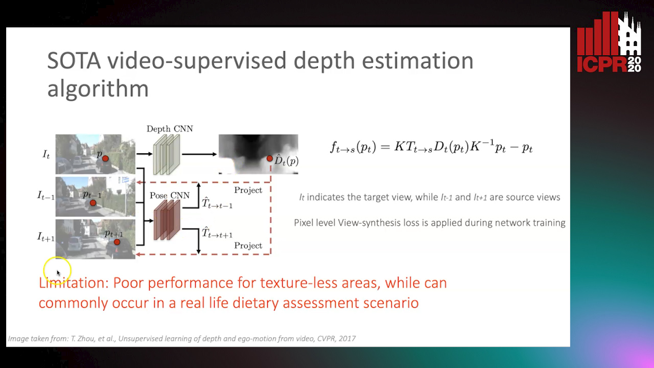
Auto-TLDR; Food Volume Estimation from a Single Food Image via Geometric Understanding and Semantic Prediction

Slides Poster Similar

Food volume estimation is an essential step in the pipeline of dietary assessment and demands the precise depth estimation of the food surface and table plane. Existing methods based on computer vision require either multi-image input or additional depth maps, reducing convenience of implementation and practical significance. Despite the recent advances in unsupervised depth estimation from a single image, the achieved performance in the case of large texture-less areas needs to be improved. In this paper, we propose a network architecture that jointly performs geometric understanding (i.e., depth prediction and 3D plane estimation) and semantic prediction on a single food image, enabling a robust and accurate food volume estimation regardless of the texture characteristics of the target plane. For the training of the network, only monocular videos with semantic ground truth are required, while the depth map and 3D plane ground truth are no longer needed. Experimental results on two separate food image databases demonstrate that our method performs robustly on texture-less scenarios and is superior to unsupervised networks and structure from motion based approaches, while it achieves comparable performance to fully-supervised methods.

Learning Non-Rigid Surface Reconstruction from Spatio-Temporal Image Patches

Matteo Pedone, Abdelrahman Mostafa, Janne Heikkilä

Responsive image

Auto-TLDR; Dense Spatio-Temporal Depth Maps of Deformable Objects from Video Sequences

Slides Poster Similar

We present a method to reconstruct a dense spatio-temporal depth map of a non-rigidly deformable object directly from a video sequence. The estimation of depth is performed locally on spatio-temporal patches of the video, and then the full depth video of the entire shape is recovered by combining them together. Since the geometric complexity of a local spatio-temporal patch of a deforming non-rigid object is often simple enough to be faithfully represented with a parametric model, we artificially generate a database of small deforming rectangular meshes rendered with different material properties and light conditions, along with their corresponding depth videos, and use such data to train a convolutional neural network. We tested our method on both synthetic and Kinect data and experimentally observed that the reconstruction error is significantly lower than the one obtained using other approaches like conventional non-rigid structure from motion.

Automatically Gather Address Specific Dwelling Images Using Google Street View

Salman Khan, Carl Salvaggio

Responsive image

Auto-TLDR; Automatic Address Specific Dwelling Image Collection Using Google Street View Data

Slides Poster Similar

Exciting research is being conducted using Google’s street view imagery. Researchers can have access to training data that allows CNN training for topics ranging from assessing neighborhood environments to estimating the age of a building. However, due to the uncontrolled nature of imagery available via Google’s Street View API, data collection can be lengthy and tedious. In an effort to help researchers gather address specific dwelling images efficiently, we developed an innovative and novel way of automatically performing this task. It was accomplished by exploiting Google’s publicly available platform with a combination of 3 separate network types and postprocessing techniques. Our uniquely developed NMS technique helped achieve 99.4%, valid, address specific dwelling images.

Deep Realistic Novel View Generation for City-Scale Aerial Images

Koundinya Nouduri, Ke Gao, Joshua Fraser, Shizeng Yao, Hadi Aliakbarpour, Filiz Bunyak, Kannappan Palaniappan

Responsive image

Auto-TLDR; End-to-End 3D Voxel Renderer for Multi-View Stereo Data Generation and Evaluation

Slides Poster Similar

In this paper we introduce a novel end-to-end frameworkfor generation of large, aerial, city-scale, realistic syntheticimage sequences with associated accurate and precise camerametadata. The two main purposes for this data are (i) to en-able objective, quantitative evaluation of computer vision al-gorithms and methods such as feature detection, description,and matching or full computer vision pipelines such as 3D re-construction; and (ii) to supply large amounts of high qualitytraining data for deep learning guided computer vision meth-ods. The proposed framework consists of three main mod-ules, a 3D voxel renderer for data generation, a deep neu-ral network for artifact removal, and a quantitative evaluationmodule for Multi-View Stereo (MVS) as an example. The3D voxel renderer enables generation of seen or unseen viewsof a scene from arbitary camera poses with accurate camerametadata parameters. The artifact removal module proposes anovel edge-augmented deep learning network with an explicitedgemap processing stream to remove image artifacts whilepreserving and recovering scene structures for more realis-tic results. Our experiments on two urban, city-scale, aerialdatasets for Albuquerque (ABQ), NM and Los Angeles (LA),CA show promising results in terms structural similarity toreal data and accuracy of reconstructed 3D point clouds

EAGLE: Large-Scale Vehicle Detection Dataset in Real-World Scenarios Using Aerial Imagery

Seyed Majid Azimi, Reza Bahmanyar, Corentin Henry, Kurz Franz

Responsive image

Auto-TLDR; EAGLE: A Large-Scale Dataset for Multi-class Vehicle Detection with Object Orientation Information in Airborne Imagery

Slides Similar

Multi-class vehicle detection from airborne imagery with orientation estimation is an important task in the near and remote vision domains with applications in traffic monitoring and disaster management. In the last decade, we have witnessed significant progress in object detection in ground imagery, but it is still in its infancy in airborne imagery, mostly due to the scarcity of diverse and large-scale datasets. Despite being a useful tool for different applications, current airborne datasets only partially reflect the challenges of real-world scenarios. To address this issue, we introduce EAGLE (oriEnted object detection using Aerial imaGery in real-worLd scEnarios), a large-scale dataset for multi-class vehicle detection with object orientation information in aerial imagery. It features high-resolution aerial images composed of different real-world situations with a wide variety of camera sensor, resolution, flight altitude, weather, illumination, haze, shadow, time, city, country, occlusion, and camera angle. The annotation was done by airborne imagery experts with small- and large-vehicle classes. EAGLE contains 215,986 instances annotated with oriented bounding boxes defined by four points and orientation, making it by far the largest dataset to date in this task. It also supports researches on the haze and shadow removal as well as super-resolution and in-painting applications. We define three tasks: detection by (1) horizontal bounding boxes, (2) rotated bounding boxes, and (3) oriented bounding boxes. We carried out several experiments to evaluate several state-of-the-art methods in object detection on our dataset to form a baseline. Experiments show that the EAGLE dataset accurately reflects real-world situations and correspondingly challenging applications. The dataset will be made publicly available.

Multiple Future Prediction Leveraging Synthetic Trajectories

Lorenzo Berlincioni, Federico Becattini, Lorenzo Seidenari, Alberto Del Bimbo

Responsive image

Auto-TLDR; Synthetic Trajectory Prediction using Markov Chains

Slides Poster Similar

Trajectory prediction is an important task, especially in autonomous driving. The ability to forecast the position of other moving agents can yield to an effective planning, ensuring safety for the autonomous vehicle as well for the observed entities. In this work we propose a data driven approach based on Markov Chains to generate synthetic trajectories, which are useful for training a multiple future trajectory predictor. The advantages are twofold: on the one hand synthetic samples can be used to augment existing datasets and train more effective predictors; on the other hand, it allows to generate samples with multiple ground truths, corresponding to diverse equally likely outcomes of the observed trajectory. We define a trajectory prediction model and a loss that explicitly address the multimodality of the problem and we show that combining synthetic and real data leads to prediction improvements, obtaining state of the art results.

Vehicle Lane Merge Visual Benchmark

Kai Cordes, Hellward Broszio

Responsive image

Auto-TLDR; A Benchmark for Automated Cooperative Maneuvering Using Multi-view Video Streams and Ground Truth Vehicle Description

Slides Poster Similar

Automated driving is regarded as the most promising technology for improving road safety in the future. In this context, connected vehicles have an important role regarding their ability to perform cooperative maneuvers for challenging traffic situations. We propose a benchmark for automated cooperative maneuvers. The targeted cooperative maneuver is the vehicle lane merge where a vehicle on the acceleration lane merges into the traffic of a motorway. The benchmark enables the evaluation of vehicle localization approaches as well as the study of cooperative maneuvers. It consists of temporally synchronized multi-view video streams, highly accurate camera calibration, and ground truth vehicle descriptions, including position, heading, speed, and shape. For benchmark generation, the lane merge maneuver is performed by human drivers on a test track, resulting in 120 lane merge data sets with various traffic situations and video recording conditions.

A Fine-Grained Dataset and Its Efficient Semantic Segmentation for Unstructured Driving Scenarios

Kai Andreas Metzger, Peter Mortimer, Hans J "Joe" Wuensche

Responsive image

Auto-TLDR; TAS500: A Semantic Segmentation Dataset for Autonomous Driving in Unstructured Environments

Slides Poster Similar

Research in autonomous driving for unstructured environments suffers from a lack of semantically labeled datasets compared to its urban counterpart. Urban and unstructured outdoor environments are challenging due to the varying lighting and weather conditions during a day and across seasons. In this paper, we introduce TAS500, a novel semantic segmentation dataset for autonomous driving in unstructured environments. TAS500 offers fine-grained vegetation and terrain classes to learn drivable surfaces and natural obstacles in outdoor scenes effectively. We evaluate the performance of modern semantic segmentation models with an additional focus on their efficiency. Our experiments demonstrate the advantages of fine-grained semantic classes to improve the overall prediction accuracy, especially along the class boundaries. The dataset, code, and pretrained model are available online.

Polarimetric Image Augmentation

Marc Blanchon, Fabrice Meriaudeau, Olivier Morel, Ralph Seulin, Desire Sidibe

Responsive image

Auto-TLDR; Polarimetric Augmentation for Deep Learning in Robotics Applications

Poster Similar

This paper deals with new augmentation methods for an unconventional imaging modality sensitive to the physics of the observed scene called polarimetry. In nature, polarized light is obtained by reflection or scattering. Robotics applications in urban environments are subject to many obstacles that can be specular and therefore provide polarized light. These areas are prone to segmentation errors using standard modalities but could be solved using information carried by the polarized light. Deep Convolutional Neural Networks (DCNNs) have shown excellent segmentation results, but require a significant amount of data to achieve best performances. The lack of data is usually overcomed by using augmentation methods. However, unlike RGB images, polarization images are not only scalar (intensity) images and standard augmentation techniques cannot be applied straightforwardly. We propose enhancing deep learning models through a regularized augmentation procedure applied to polarimetric data in order to characterize scenes more effectively under challenging conditions. We subsequently observe an average of 18.1% improvement in IoU between not augmented and regularized training procedures on real world data.

Machine-Learned Regularization and Polygonization of Building Segmentation Masks

Stefano Zorzi, Ksenia Bittner, Friedrich Fraundorfer

Responsive image

Auto-TLDR; Automatic Regularization and Polygonization of Building Segmentation masks using Generative Adversarial Network

Slides Poster Similar

We propose a machine learning based approach for automatic regularization and polygonization of building segmentation masks. Taking an image as input, we first predict building segmentation maps exploiting generic fully convolutional network (FCN). A generative adversarial network (GAN) is then involved to perform a regularization of building boundaries to make them more realistic, i.e., having more rectilinear outlines which construct right angles if required. This is achieved through the interplay between the discriminator which gives a probability of input image being true and generator that learns from discriminator’s response to create more realistic images. Finally, we train the backbone convolutional neural network (CNN) which is adapted to predict sparse outcomes corresponding to building corners out of regularized building segmentation results. Experiments on three building segmentation datasets demonstrate that the proposed method is not only capable of obtaining accurate results, but also of producing visually pleasing building outlines parameterized as polygons.

NetCalib: A Novel Approach for LiDAR-Camera Auto-Calibration Based on Deep Learning

Shan Wu, Amnir Hadachi, Damien Vivet, Yadu Prabhakar

Responsive image

Auto-TLDR; Automatic Calibration of LiDAR and Cameras using Deep Neural Network

Slides Poster Similar

A fusion of LiDAR and cameras have been widely used in many robotics applications such as classification, segmentation, object detection, and autonomous driving. It is essential that the LiDAR sensor can measure distances accurately, which is a good complement to the cameras. Hence, calibrating sensors before deployment is a mandatory step. The conventional methods include checkerboards, specific patterns, or human labeling, which is trivial and human-labor extensive if we do the same calibration process every time. The main propose of this research work is to build a deep neural network that is capable of automatically finding the geometric transformation between LiDAR and cameras. The results show that our model manages to find the transformations from randomly sampled artificial errors. Besides, our work is open-sourced for the community to fully utilize the advances of the methodology for developing more the approach, initiating collaboration, and innovation in the topic.

Street-Map Based Validation of Semantic Segmentation in Autonomous Driving

Laura Von Rueden, Tim Wirtz, Fabian Hueger, Jan David Schneider, Nico Piatkowski, Christian Bauckhage

Responsive image

Auto-TLDR; Semantic Segmentation Mask Validation Using A-priori Knowledge from Street Maps

Slides Poster Similar

Artificial intelligence for autonomous driving must meet strict requirements on safety and robustness, which motivates the thorough validation of learned models. However, current validation approaches mostly require ground truth data and are thus both cost-intensive and limited in their applicability. We propose to overcome these limitations by a model agnostic validation using a-priori knowledge from street maps. In particular, we show how to validate semantic segmentation masks and demonstrate the potential of our approach using OpenStreetMap. We introduce validation metrics that indicate false positive or negative road segments. Besides the validation approach, we present a method to correct the vehicle's GPS position so that a more accurate localization can be used for the street map based validation. Lastly, we present quantitative results on the Cityscapes dataset indicating that our validation approach can indeed uncover errors in semantic segmentation masks.

Hybrid Approach for 3D Head Reconstruction: Using Neural Networks and Visual Geometry

Oussema Bouafif, Bogdan Khomutenko, Mohammed Daoudi

Responsive image

Auto-TLDR; Recovering 3D Head Geometry from a Single Image using Deep Learning and Geometric Techniques

Slides Poster Similar

Recovering the 3D geometric structure of a face from a single input image is a challenging active research area in computer vision. In this paper, we present a novel method for reconstructing 3D heads from a single or multiple image(s) using a hybrid approach based on deep learning and geometric techniques. We propose an encoder-decoder network based on the U-net architecture and trained on synthetic data only. It predicts both pixel-wise normal vectors and landmarks maps from a single input photo. Landmarks are used for the pose computation and the initialization of the optimization problem, which, in turn, reconstructs the 3D head geometry by using a parametric morphable model and normal vector fields. State-of-the-art results are achieved through qualitative and quantitative evaluation tests on both single and multi-view settings. Despite the fact that the model was trained only on synthetic data, it successfully recovers 3D geometry and precise poses for real-world images.

CARRADA Dataset: Camera and Automotive Radar with Range-Angle-Doppler Annotations

Arthur Ouaknine, Alasdair Newson, Julien Rebut, Florence Tupin, Patrick Pérez

Responsive image

Auto-TLDR; CARRADA: A dataset of synchronized camera and radar recordings with range-angle-Doppler annotations for autonomous driving

Slides Poster Similar

High quality perception is essential for autonomous driving (AD) systems. To reach the accuracy and robustness that are required by such systems, several types of sensors must be combined. Currently, mostly cameras and laser scanners (lidar) are deployed to build a representation of the world around the vehicle. While radar sensors have been used for a long time in the automotive industry, they are still under-used for AD despite their appealing characteristics (notably, their ability to measure the relative speed of obstacles and to operate even in adverse weather conditions). To a large extent, this situation is due to the relative lack of automotive datasets with real radar signals that are both raw and annotated. In this work, we introduce CARRADA, a dataset of synchronized camera and radar recordings with range-angle-Doppler annotations. We also present a semi-automatic annotation approach, which was used to annotate the dataset, and a radar semantic segmentation baseline, which we evaluate on several metrics. Both our code and dataset will be released.

Real-Time Monocular Depth Estimation with Extremely Light-Weight Neural Network

Mian Jhong Chiu, Wei-Chen Chiu, Hua-Tsung Chen, Jen-Hui Chuang

Responsive image

Auto-TLDR; Real-Time Light-Weight Depth Prediction for Obstacle Avoidance and Environment Sensing with Deep Learning-based CNN

Slides Poster Similar

Obstacle avoidance and environment sensing are crucial applications in autonomous driving and robotics. Among all types of sensors, RGB camera is widely used in these applications as it can offer rich visual contents with relatively low-cost, and using a single image to perform depth estimation has become one of the main focuses in resent research works. However, prior works usually rely on highly complicated computation and power-consuming GPU to achieve such task; therefore, we focus on developing a real-time light-weight system for depth prediction in this paper. Based on the well-known encoder-decoder architecture, we propose a supervised learning-based CNN with detachable decoders that produce depth predictions with different scales. We also formulate a novel log-depth loss function that computes the difference of predicted depth map and ground truth depth map in log space, so as to increase the prediction accuracy for nearby locations. To train our model efficiently, we generate depth map and semantic segmentation with complex teacher models. Via a series of ablation studies and experiments, it is validated that our model can efficiently performs real-time depth prediction with only 0.32M parameters, with the best trained model outperforms previous works on KITTI dataset for various evaluation matrices.

Calibration and Absolute Pose Estimation of Trinocular Linear Camera Array for Smart City Applications

Martin Ahrnbom, Mikael Nilsson, Håkan Ardö, Kalle Åström, Oksana Yastremska-Kravchenko, Aliaksei Laureshyn

Responsive image

Auto-TLDR; Trinocular Linear Camera Array Calibration for Traffic Surveillance Applications

Slides Poster Similar

A method for calibrating a Trinocular Linear Camera Array (TLCA) for traffic surveillance applications, such as towards smart cities, is presented. A TLCA-specific parametrization guarantees that the calibration finds a model where all the cameras are on a straight line. The method uses both a chequerboard close to the camera, as well as measured 3D points far from the camera: points measured in world coordinates, as well as their corresponding 2D points found manually in the images. Superior calibration accuracy can be obtained compared to standard methods using only a single data source, largely due to the use of chequerboards, while the line constraint in the parametrization allows for joint rectification. The improved triangulation accuracy, from 8-12 cm to around 6 cm when calibrating with 30-50 points in our experiment, allowing better road user analysis. The method is demonstrated by a proof-of-concept application where a point cloud is generated from multiple disparity maps, visualizing road user detections in 3D.

Unconstrained Vision Guided UAV Based Safe Helicopter Landing

Arindam Sikdar, Abhimanyu Sahu, Debajit Sen, Rohit Mahajan, Ananda Chowdhury

Responsive image

Auto-TLDR; Autonomous Helicopter Landing in Hazardous Environments from Unmanned Aerial Images Using Constrained Graph Clustering

Slides Poster Similar

In this paper, we have addressed the problem of automated detection of safe zone(s) for helicopter landing in hazardous environments from images captured by an Unmanned Aerial Vehicle (UAV). The unconstrained motion of the image capturing drone (the UAV in our case) makes the problem further difficult. The solution pipeline consists of natural landmark detection and tracking, stereo-pair generation using constrained graph clustering, digital terrain map construction and safe landing zone detection. The main methodological contribution lies in mathematically formulating epipolar constraint and then using it in a Minimum Spanning Tree (MST) based graph clustering approach. We have also made publicly available AHL (Autonomous Helicopter Landing) dataset, a new aerial video dataset captured by a drone, with annotated ground-truths. Experimental comparisons with other competing clustering methods i) in terms of Dunn Index and Davies Bouldin Index as well as ii) for frame-level safe zone detection in terms of F-measure and confusion matrix clearly demonstrate the effectiveness of the proposed formulation.

Quantization in Relative Gradient Angle Domain for Building Polygon Estimation

Yuhao Chen, Yifan Wu, Linlin Xu, Alexander Wong

Responsive image

Auto-TLDR; Relative Gradient Angle Transform for Building Footprint Extraction from Remote Sensing Data

Slides Poster Similar

Building footprint extraction in remote sensing data benefits many important applications, such as urban planning and population estimation. Recently, rapid development of Convolutional Neural Networks (CNNs) and open-sourced high resolution satellite building image datasets have pushed the performance boundary further for automated building extractions. However, CNN approaches often generate imprecise building morphologies including noisy edges and round corners. In this paper, we leverage the performance of CNNs, and propose a module that uses prior knowledge of building corners to create angular and concise building polygons from CNN segmentation outputs. We describe a new transform, Relative Gradient Angle Transform (RGA Transform) that converts object contours from time vs. space to time vs. angle. We propose a new shape descriptor, Boundary Orientation Relation Set (BORS), to describe angle relationship between edges in RGA domain, such as orthogonality and parallelism. Finally, we develop an energy minimization framework that makes use of the angle relationship in BORS to straighten edges and reconstruct sharp corners, and the resulting corners create a polygon. Experimental results demonstrate that our method refines CNN output from a rounded approximation to a more clear-cut angular shape of the building footprint.

Self-Supervised Detection and Pose Estimation of Logistical Objects in 3D Sensor Data

Nikolas Müller, Jonas Stenzel, Jian-Jia Chen

Responsive image

Auto-TLDR; A self-supervised and fully automated deep learning approach for object pose estimation using simulated 3D data

Slides Poster Similar

Localization of objects in cluttered scenes with machine learning methods is a fairly young research area. Despite the high potential of object localization for full process automation in Industry 4.0 and logistical environments, 3D data sets for such applications to train machine learning models are not openly available and less publications have been made on that topic. To the authors knowledge, this is the first publication that describes a self-supervised and fully automated deep learning approach for object pose estimation using simulated 3D data. The solution covers the simulated generation of training data, the detection of objects in point clouds using a fully convolutional feedforward network and the computation of the pose for each detected object instance.

Distortion-Adaptive Grape Bunch Counting for Omnidirectional Images

Ryota Akai, Yuzuko Utsumi, Yuka Miwa, Masakazu Iwamura, Koichi Kise

Responsive image

Auto-TLDR; Object Counting for Omnidirectional Images Using Stereographic Projection

Poster Similar

This paper proposes the first object counting method for omnidirectional images. Because conventional object counting methods cannot handle the distortion of omnidirectional images, we propose to process them using stereographic projection, which enables conventional methods to obtain a good approximation of the density function. However, the images obtained by stereographic projection are still distorted. Hence, to manage this distortion, we propose two methods. One is a new data augmentation method designed for the stereographic projection of omnidirectional images. The other is a distortion-adaptive Gaussian kernel that generates a density map ground truth while taking into account the distortion of stereographic projection. Using the counting of grape bunches as a case study, we constructed an original grape-bunch image dataset consisting of omnidirectional images and conducted experiments to evaluate the proposed method. The results show that the proposed method performs better than a direct application of the conventional method, improving mean absolute error by 14.7% and mean squared error by 10.5%.

Edge-Aware Monocular Dense Depth Estimation with Morphology

Zhi Li, Xiaoyang Zhu, Haitao Yu, Qi Zhang, Yongshi Jiang

Responsive image

Auto-TLDR; Spatio-Temporally Smooth Dense Depth Maps Using Only a CPU

Slides Poster Similar

Dense depth maps play an important role in Computer Vision and AR (Augmented Reality). For CV applications, a dense depth map is the cornerstone of 3D reconstruction allowing real objects to be precisely displayed in the computer. And Dense depth maps can handle correct occlusion relationships between virtual content and real objects for better user experience in AR. However, the complicated computation limits the development of computing dense depth maps. We present a novel algorithm that produces low latency, spatio-temporally smooth dense depth maps using only a CPU. The depth maps exhibit sharp discontinuities at depth edges in low computational complexity ways. Our algorithm obtains the sparse SLAM reconstruction first, then extracts coarse depth edges from a down-sampled RGB image by morphology operations. Next, we thin the depth edges and align them with image edges. Finally, a Warm-Start initialization scheme and an improved optimization solver are adopted to accelerate convergence. We evaluate our proposal quantitatively and the result shows improvements on the accuracy of depth map with respect to other state-of-the-art and baseline techniques.

RescueNet: Joint Building Segmentation and Damage Assessment from Satellite Imagery

Rohit Gupta, Mubarak Shah

Responsive image

Auto-TLDR; RescueNet: End-to-End Building Segmentation and Damage Classification for Humanitarian Aid and Disaster Response

Slides Poster Similar

Accurate and fine-grained information about the extent of damage to buildings is essential for directing Humanitarian Aid and Disaster Response (HADR) operations in the immediate aftermath of any natural calamity. In recent years, satellite and UAV (drone) imagery has been used for this purpose, sometimes aided by computer vision algorithms. Existing Computer Vision approaches for building damage assessment typically rely on a two stage approach, consisting of building detection using an object detection model, followed by damage assessment through classification of the detected building tiles. These multi-stage methods are not end-to-end trainable, and suffer from poor overall results. We propose RescueNet, a unified model that can simultaneously segment buildings and assess the damage levels to individual buildings and can be trained end-to end. In order to to model the composite nature of this problem, we propose a novel localization aware loss function, which consists of a Binary Cross Entropy loss for building segmentation, and a foreground only selective Categorical Cross-Entropy loss for damage classification, and show significant improvement over the widely used Cross-Entropy loss. RescueNet is tested on the large scale and diverse xBD dataset and achieves significantly better building segmentation and damage classification performance than previous methods and achieves generalization across varied geographical regions and disaster types.

Visual Localization for Autonomous Driving: Mapping the Accurate Location in the City Maze

Dongfang Liu, Yiming Cui, Xiaolei Guo, Wei Ding, Baijian Yang, Yingjie Chen

Responsive image

Auto-TLDR; Feature Voting for Robust Visual Localization in Urban Settings

Slides Poster Similar

Accurate localization is a foundational capacity, required for autonomous vehicles to accomplish other tasks such as navigation or path planning. It is a common practice for vehicles to use GPS to acquire location information. However, the application of GPS can result in severe challenges when vehicles run within the inner city where different kinds of structures may shadow the GPS signal and lead to inaccurate location results. To address the localization challenges of urban settings, we propose a novel feature voting technique for visual localization. Different from the conventional front-view-based method, our approach employs views from three directions (front, left, and right) and thus significantly improves the robustness of location prediction. In our work, we craft the proposed feature voting method into three state-of-the-art visual localization networks and modify their architectures properly so that they can be applied for vehicular operation. Extensive field test results indicate that our approach can predict location robustly even in challenging inner-city settings. Our research sheds light on using the visual localization approach to help autonomous vehicles to find accurate location information in a city maze, within a desirable time constraint.

AerialMPTNet: Multi-Pedestrian Tracking in Aerial Imagery Using Temporal and Graphical Features

Maximilian Kraus, Seyed Majid Azimi, Emec Ercelik, Reza Bahmanyar, Peter Reinartz, Alois Knoll

Responsive image

Auto-TLDR; AerialMPTNet: A novel approach for multi-pedestrian tracking in geo-referenced aerial imagery by fusing appearance features

Slides Poster Similar

Multi-pedestrian tracking in aerial imagery has several applications such as large-scale event monitoring, disaster management, search-and-rescue missions, and as input into predictive crowd dynamic models. Due to the challenges such as the large number and the tiny size of the pedestrians (e.g., 4 x 4 pixels) with their similar appearances as well as different scales and atmospheric conditions of the images with their extremely low frame rates (e.g., 2 fps), current state-of-the-art algorithms including the deep learning-based ones are unable to perform well. In this paper, we propose AerialMPTNet, a novel approach for multi-pedestrian tracking in geo-referenced aerial imagery by fusing appearance features from a Siamese Neural Network, movement predictions from a Long Short-Term Memory, and pedestrian interconnections from a GraphCNN. In addition, to address the lack of diverse aerial multi-pedestrian tracking datasets, we introduce the Aerial Multi-Pedestrian Tracking (AerialMPT) dataset consisting of 307 frames and 44,740 pedestrians annotated. To the best of our knowledge, AerialMPT is the largest and most diverse dataset to this date and will be released publicly. We evaluate AerialMPTNet on AerialMPT and KIT AIS, and benchmark with several state-of-the-art tracking methods. Results indicate that AerialMPTNet significantly outperforms other methods on accuracy and time-efficiency.

Benchmarking Cameras for OpenVSLAM Indoors

Kevin Chappellet, Guillaume Caron, Fumio Kanehiro, Ken Sakurada, Abderrahmane Kheddar

Responsive image

Auto-TLDR; OpenVSLAM: Benchmarking Camera Types for Visual Simultaneous Localization and Mapping

Slides Poster Similar

In this paper we benchmark different types of cameras and evaluate their performance in terms of reliable localization reliability and precision in Visual Simultaneous Localization and Mapping (vSLAM). Such benchmarking is merely found for visual odometry, but never for vSLAM. Existing studies usually compare several algorithms for a given camera. %This work is the first to handle the dual of the latter, i.e. comparing several cameras for a given SLAM algorithm. The evaluation methodology we propose is applied to the recent OpenVSLAM framework. The latter is versatile enough to natively deal with perspective, fisheye, 360 cameras in a monocular or stereoscopic setup, an in RGB or RGB-D modalities. Results in various sequences containing light variation and scenery modifications in the scene assess quantitatively the maximum localization rate for 360 vision. In the contrary, RGB-D vision shows the lowest localization rate, but highest precision when localization is possible. Stereo-fisheye trades-off with localization rates and precision between 360 vision and RGB-D vision. The dataset with ground truth will be made available in open access to allow evaluating other/future vSLAM algorithms with respect to these camera types.

Anomaly Detection, Localization and Classification for Railway Inspection

Riccardo Gasparini, Andrea D'Eusanio, Guido Borghi, Stefano Pini, Giuseppe Scaglione, Simone Calderara, Eugenio Fedeli, Rita Cucchiara

Responsive image

Auto-TLDR; Anomaly Detection and Localization using thermal images in the lowlight environment

Slides Similar

The ability to detect, localize and classify objects that are anomalies is a challenging task in the computer vision community. In this paper, we tackle these tasks developing a framework to automatically inspect the railway during the night. Specifically, it is able to predict the presence, the image coordinates and the class of obstacles. To deal with the lowlight environment, the framework is based on thermal images and consists of three different modules that address the problem of detecting anomalies, predicting their image coordinates and classifying them. Moreover, due to the absolute lack of publicly released datasets collected in the railway context for anomaly detection, we introduce a new multi-modal dataset, acquired from a rail drone, used to evaluate the proposed framework. Experimental results confirm the accuracy of the framework and its suitability, in terms of computational load, performance, and inference time, to be implemented on a self-powered inspection system.

Aerial Road Segmentation in the Presence of Topological Label Noise

Corentin Henry, Friedrich Fraundorfer, Eleonora Vig

Responsive image

Auto-TLDR; Improving Road Segmentation with Noise-Aware U-Nets for Fine-Grained Topology delineation

Slides Poster Similar

The availability of large-scale annotated datasets has enabled Fully-Convolutional Neural Networks to reach outstanding performance on road extraction in aerial images. However, high-quality pixel-level annotation is expensive to produce and even manually labeled data often contains topological errors. Trading off quality for quantity, many datasets rely on already available yet noisy labels, for example from OpenStreetMap. In this paper, we explore the training of custom U-Nets built with ResNet and DenseNet backbones using noise-aware losses that are robust towards label omission and registration noise. We perform an extensive evaluation of standard and noise-aware losses, including a novel Bootstrapped DICE-Coefficient loss, on two challenging road segmentation benchmarks. Our losses yield a consistent improvement in overall extraction quality and exhibit a strong capacity to cope with severe label noise. Our method generalizes well to two other fine-grained topology delineation tasks: surface crack detection for quality inspection and cell membrane extraction in electron microscopy imagery.

The DeepScoresV2 Dataset and Benchmark for Music Object Detection

Lukas Tuggener, Yvan Putra Satyawan, Alexander Pacha, Jürgen Schmidhuber, Thilo Stadelmann

Responsive image

Auto-TLDR; DeepScoresV2: an extended version of the DeepScores dataset for optical music recognition

Slides Poster Similar

In this paper, we present DeepScoresV2, an extended version of the DeepScores dataset for optical music recognition (OMR). We improve upon the original DeepScores dataset by providing much more detailed annotations, namely (a) annotations for 135 classes including fundamental symbols of non-fixed size and shape, increasing the number of annotated symbols by 23%; (b) oriented bounding boxes; (c) higher-level rhythm and pitch information (onset beat for all symbols and line position for noteheads); and (d) a compatibility mode for easy use in conjunction with the MUSCIMA++ dataset for OMR on handwritten documents. These additions open up the potential for future advancement in OMR research. Additionally, we release two state-of-the-art baselines for DeepScoresV2 based on Faster R-CNN and the Deep Watershed Detector. An analysis of the baselines shows that regular orthogonal bounding boxes are unsuitable for objects which are long, small, and potentially rotated, such as ties and beams, which demonstrates the need for detection algorithms that naturally incorporate object angles. Dataset, code and pre-trained models, as well as user instructions, are publicly available at https://tuggeluk.github.io/dsv2_preview/

Towards Efficient 3D Point Cloud Scene Completion Via Novel Depth View Synthesis

Haiyan Wang, Liang Yang, Xuejian Rong, Ying-Li Tian

Responsive image

Auto-TLDR; 3D Point Cloud Completion with Depth View Synthesis and Depth View synthesis

Poster Similar

3D point cloud completion has been a long-standing challenge at scale, and corresponding per-point supervised training strategies suffered from the cumbersome annotations. 2D supervision has recently emerged as a promising alternative for 3D tasks, but specific approaches for 3D point cloud completion still remain to be explored. To overcome these limitations, we propose an end-to-end method that directly lifts a single depth map to a completed point cloud. With one depth map as input, a multi-way novel depth view synthesis network (NDVNet) is designed to infer coarsely completed depth maps under various viewpoints. Meanwhile, a geometric depth perspective rendering module is introduced to utilize the raw input depth map to generate a re-projected depth map for each view. Therefore, the two parallelly generated depth maps for each view are further concatenated and refined by a depth completion network (DCNet). The final completed point cloud is fused from all refined depth views. Experimental results demonstrate the effectiveness of our proposed approach composed of aforementioned components, to produce high-quality state-of-the-art results on the popular SUNCG benchmark.

Attention Based Coupled Framework for Road and Pothole Segmentation

Shaik Masihullah, Ritu Garg, Prerana Mukherjee, Anupama Ray

Responsive image

Auto-TLDR; Few Shot Learning for Road and Pothole Segmentation on KITTI and IDD

Slides Poster Similar

In this paper, we propose a novel attention based coupled framework for road and pothole segmentation. In many developing countries as well as in rural areas, the drivable areas are neither well-defined, nor well-maintained. Under such circumstances, an Advance Driver Assistant System (ADAS) is needed to assess the drivable area and alert about the potholes ahead to ensure vehicle safety. Moreover, this information can also be used in structured environments for assessment and maintenance of road health. We demonstrate few shot learning approach for pothole detection to leverage accuracy even with fewer training samples. We report the exhaustive experimental results for road segmentation on KITTI and IDD datasets. We also present pothole segmentation on IDD.

Future Urban Scenes Generation through Vehicles Synthesis

Alessandro Simoni, Luca Bergamini, Andrea Palazzi, Simone Calderara, Rita Cucchiara

Responsive image

Auto-TLDR; Predicting the Future of an Urban Scene with a Novel View Synthesis Paradigm

Slides Poster Similar

In this work we propose a deep learning pipeline to predict the visual future appearance of an urban scene. Despite recent advances, generating the entire scene in an end-to-end fashion is still far from being achieved. Instead, here we follow a two stages approach, where interpretable information is included in the loop and each actor is modelled independently. We leverage a per-object novel view synthesis paradigm; i.e. generating a synthetic representation of an object undergoing a geometrical roto-translation in the 3D space. Our model can be easily conditioned with constraints (e.g. input trajectories) provided by state-of-the-art tracking methods or by the user itself. This allows us to generate a set of diverse realistic futures starting from the same input in a multi-modal fashion. We visually and quantitatively show the superiority of this approach over traditional end-to-end scene-generation methods on CityFlow, a challenging real world dataset.

HPERL: 3D Human Pose Estimastion from RGB and LiDAR

Michael Fürst, Shriya T.P. Gupta, René Schuster, Oliver Wasenmüler, Didier Stricker

Responsive image

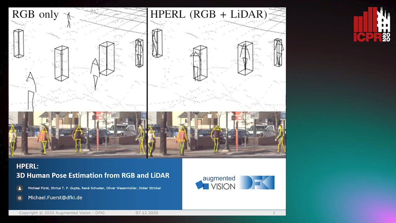
Auto-TLDR; 3D Human Pose Estimation Using RGB and LiDAR Using Weakly-Supervised Approach

Slides Poster Similar

In-the-wild human pose estimation has a huge potential for various fields, ranging from animation and action recognition to intention recognition and prediction for autonomous driving. The current state-of-the-art is focused only on RGB and RGB-D approaches for predicting the 3D human pose. However, not using precise LiDAR depth information limits the performance and leads to very inaccurate absolute pose estimation. With LiDAR sensors becoming more affordable and common on robots and autonomous vehicle setups, we propose an end-to-end architecture using RGB and LiDAR to predict the absolute 3D human pose with unprecedented precision. Additionally, we introduce a weakly-supervised approach to generate 3D predictions using 2D pose annotations from PedX. This allows for many new opportunities in the field of 3D human pose estimation.

IPT: A Dataset for Identity Preserved Tracking in Closed Domains

Thomas Heitzinger, Martin Kampel

Responsive image

Auto-TLDR; Identity Preserved Tracking Using Depth Data for Privacy and Privacy

Slides Poster Similar

We present a public dataset for Identity Preserved Tracking (IPT) consisting of sequences of depth data recorded using an Orbbec Astra depth sensor. The dataset features sequences in ten different locations with a high amount of background variation and is designed to be applicable to a wide range of tasks. Its labeling is versatile, allowing for tracking in either 3d space or image coordinates. Next to frame-by-frame 3d and inferred bounding box labeling we provide supplementary annotation of camera poses and room layouts, split in multiple semantically distinct categories. Intended use-cases are applications where both a high level understanding of scene understanding and privacy are central points of consideration, such as active and assisted living (AAL), security and industrial safety. Compared to similar public datasets IPT distinguishes itself with its sequential data format, 3d instance labeling and room layout annotation. We present baseline object detection results in image coordinates using a YOLOv3 network architecture and implement a background model suitable for online tracking applications to increase detection accuracy. Additionally we propose a novel volumetric non-maximum suppression (V-NMS) approach, taking advantage of known room geometry. Last we provide baseline person tracking results utilizing Multiple Object Tracking Challenge (MOTChallenge) evaluation metrics of the CVPR19 benchmark.

End-To-End Deep Learning Methods for Automated Damage Detection in Extreme Events at Various Scales

Yongsheng Bai, Alper Yilmaz, Halil Sezen

Responsive image

Auto-TLDR; Robust Mask R-CNN for Crack Detection in Extreme Events

Slides Poster Similar

Robust Mask R-CNN (Mask Regional Convolutional Neural Network) methods are proposed and tested for automatic detection of cracks on structures or their components that may be damaged during extreme events, such as earth-quakes. We curated a new dataset with 2,021 labeled images for training and validation and aimed to find end-to-end deep neural networks for crack detection in the field. With data augmentation and parameters fine-tuning, Path Aggregation Network (PANet) with spatial attention mechanisms and High-resolution Network (HRNet) are introduced into Mask R-CNNs. The tests on three public datasets with low- or high-resolution images demonstrate that the proposed methods can achieve a big improvement over alternative networks, so the proposed method may be sufficient for crack detection for a variety of scales in real applications.

SAILenv: Learning in Virtual Visual Environments Made Simple

Enrico Meloni, Luca Pasqualini, Matteo Tiezzi, Marco Gori, Stefano Melacci

Responsive image

Auto-TLDR; SAILenv: A Simple and Customized Platform for Visual Recognition in Virtual 3D Environment

Slides Poster Similar

Recently, researchers in Machine Learning algorithms, Computer Vision scientists, engineers and others, showed a growing interest in 3D simulators as a mean to artificially create experimental settings that are very close to those in the real world. However, most of the existing platforms to interface algorithms with 3D environments are often designed to setup navigation-related experiments, to study physical interactions, or to handle ad-hoc cases that are not thought to be customized, sometimes lacking a strong photorealistic appearance and an easy-to-use software interface. In this paper, we present a novel platform, SAILenv, that is specifically designed to be simple and customizable, and that allows researchers to experiment visual recognition in virtual 3D scenes. A few lines of code are needed to interface every algorithm with the virtual world, and non-3D-graphics experts can easily customize the 3D environment itself, exploiting a collection of photorealistic objects. Our framework yields pixel-level semantic and instance labeling, depth, and, to the best of our knowledge, it is the only one that provides motion-related information directly inherited from the 3D engine. The client-server communication operates at a low level, avoiding the overhead of HTTP-based data exchanges. We perform experiments using a state-of-the-art object detector trained on real-world images, showing that it is able to recognize the photorealistic 3D objects of our environment. The computational burden of the optical flow compares favourably with the estimation performed using modern GPU-based convolutional networks or more classic implementations. We believe that the scientific community will benefit from the easiness and high-quality of our framework to evaluate newly proposed algorithms in their own customized realistic conditions.

One Step Clustering Based on A-Contrario Framework for Detection of Alterations in Historical Violins

Alireza Rezaei, Sylvie Le Hégarat-Mascle, Emanuel Aldea, Piercarlo Dondi, Marco Malagodi

Responsive image

Auto-TLDR; A-Contrario Clustering for the Detection of Altered Violins using UVIFL Images

Slides Poster Similar

Preventive conservation is an important practice in Cultural Heritage. The constant monitoring of the state of conservation of an artwork helps us reduce the risk of damage and number of interventions necessary. In this work, we propose a probabilistic approach for the detection of alterations on the surface of historical violins based on an a-contrario framework. Our method is a one step NFA clustering solution which considers grey-level and spatial density information in one background model. The proposed method is robust to noise and avoids parameter tuning and any assumption about the quantity of the worn out areas. We have used as input UV induced fluorescence (UVIFL) images for considering details not perceivable with visible light. Tests were conducted on image sequences included in the ``Violins UVIFL imagery'' dataset. Results illustrate the ability of the algorithm to distinguish the worn area from the surrounding regions. Comparisons with the state of the art clustering methods shows improved overall precision and recall.

OmniFlowNet: A Perspective Neural Network Adaptation for Optical Flow Estimation in Omnidirectional Images

Charles-Olivier Artizzu, Haozhou Zhang, Guillaume Allibert, Cédric Demonceaux

Responsive image

Auto-TLDR; OmniFlowNet: A Convolutional Neural Network for Omnidirectional Optical Flow Estimation

Slides Poster Similar

Spherical cameras and the latest image processing techniques open up new horizons. In particular, methods based on Convolutional Neural Networks (CNNs) now give excellent results for optical flow estimation on perspective images. However, these approaches are highly dependent on their architectures and training datasets. This paper proposes to benefit from years of improvement in perspective images optical flow estimation and to apply it to omnidirectional ones without training on new datasets. Our network, OmniFlowNet, is built on a CNN specialized in perspective images. Its convolution operation is adapted to be consistent with the equirectangular projection. Tested on spherical datasets created with Blender and several equirectangular videos realized from real indoor and outdoor scenes, OmniFlowNet shows better performance than its original network.

Multi-Scale Residual Pyramid Attention Network for Monocular Depth Estimation

Jing Liu, Xiaona Zhang, Zhaoxin Li, Tianlu Mao

Responsive image

Auto-TLDR; Multi-scale Residual Pyramid Attention Network for Monocular Depth Estimation

Slides Poster Similar

Monocular depth estimation is a challenging problem in computer vision and is crucial for understanding 3D scene geometry. Recently, deep convolutional neural networks (DCNNs) based methods have improved the estimation accuracy significantly. However, existing methods fail to consider complex textures and geometries in scenes, thereby resulting in loss of local details, distorted object boundaries, and blurry reconstruction. In this paper, we proposed an end-to-end Multi-scale Residual Pyramid Attention Network (MRPAN) to mitigate these problems.First,we propose a Multi-scale Attention Context Aggregation (MACA) module, which consists of Spatial Attention Module (SAM) and Global Attention Module (GAM). By considering the position and scale correlation of pixels from spatial and global perspectives, the proposed module can adaptively learn the similarity between pixels so as to obtain more global context information of the image and recover the complex structure in the scene. Then we proposed an improved Residual Refinement Module (RRM) to further refine the scene structure, giving rise to deeper semantic information and retain more local details. Experimental results show that our method achieves more promisin performance in object boundaries and local details compared with other state-of-the-art methods.

5D Light Field Synthesis from a Monocular Video

Kyuho Bae, Andre Ivan, Hajime Nagahara, In Kyu Park

Responsive image

Auto-TLDR; Synthesis of Light Field Video from Monocular Video using Deep Learning

Slides Similar

Commercially available light field cameras have difficulty in capturing 5D (4D + time) light field videos. They can only capture still light filed images or are excessively expensive for normal users to capture the light field video. To tackle this problem, we propose a deep learning-based method for synthesizing a light field video from a monocular video. We propose a new synthetic light field video dataset that renders photorealistic scenes using Unreal Engine because no light field video dataset is available. The proposed deep learning framework synthesizes the light field video with a full set (9x9) of sub-aperture images from a normal monocular video. The proposed network consists of three sub-networks, namely, feature extraction, 5D light field video synthesis, and temporal consistency refinement. Experimental results show that our model can successfully synthesize the light field video for synthetic and real scenes and outperforms the previous frame-by-frame method quantitatively and qualitatively.

Minimal Solvers for Indoor UAV Positioning

Marcus Valtonen Örnhag, Patrik Persson, Mårten Wadenbäck, Kalle Åström, Anders Heyden

Responsive image

Auto-TLDR; Relative Pose Solvers for Visual Indoor UAV Navigation

Slides Poster Similar

In this paper we consider a collection of relative pose problems which arise naturally in applications for visual indoor UAV navigation. We focus on cases where additional information from an onboard IMU is available and thus provides a partial extrinsic calibration through the gravitational vector. The solvers are designed for a partially calibrated camera, for a variety of realistic indoor scenarios, which makes it possible to navigate using images of the ground floor. Current state-of-the-art solvers use more general assumptions, such as using arbitrary planar structures; however, these solvers do not yield adequate reconstructions for real scenes, nor do they perform fast enough to be incorporated in real-time systems. We show that the proposed solvers enjoy better numerical stability, are faster, and require fewer point correspondences, compared to state-of-the-art solvers. These properties are vital components for robust navigation in real-time systems, and we demonstrate on both synthetic and real data that our method outperforms other methods, and yields superior motion estimation.

Temporal Pulses Driven Spiking Neural Network for Time and Power Efficient Object Recognition in Autonomous Driving

Wei Wang, Shibo Zhou, Jingxi Li, Xiaohua Li, Junsong Yuan, Zhanpeng Jin

Responsive image

Auto-TLDR; Spiking Neural Network for Real-Time Object Recognition on Temporal LiDAR Pulses

Slides Poster Similar

Accurate real-time object recognition from sensory data has long been a crucial and challenging task for autonomous driving. Even though deep neural networks (DNNs) have been widely applied in this area, their considerable processing latency, power consumption as well as computational complexity have been challenging issues for real-time autonomous driving applications. In this paper, we propose an approach to address the real-time object recognition problem utilizing spiking neural networks (SNNs). The proposed SNN model works directly with raw temporal LiDAR pulses without the pulse-to-point cloud preprocessing procedure, which can significantly reduce delay and power consumption. Being evaluated on various datasets derived from LiDAR and dynamic vision sensor (DVS), including Sim LiDAR, KITTI, and DVS-barrel, our proposed model has shown remarkable time and power efficiency, while achieving comparable recognition performance as the state-of-the-art methods. This paper highlights the SNN's great potentials in autonomous driving and related applications. To the best of our knowledge, this is the first attempt to use SNN to directly perform time and energy efficient object recognition on temporal LiDAR pulses in the setting of autonomous driving.

Object Detection on Monocular Images with Two-Dimensional Canonical Correlation Analysis

Zifan Yu, Suya You

Responsive image

Auto-TLDR; Multi-Task Object Detection from Monocular Images Using Multimodal RGB and Depth Data

Slides Poster Similar

Accurate and robust detection objects from monocular images is a fundamental vision task. This paper describes a novel approach of holistic scene understanding that can simultaneously achieve multiple tasks of scene reconstruction and object detection from a single monocular camera. Rather than pursuing an independent solution for each individual task as most existing work does, we seek a globally optimal solution that holistically resolves the multiple perception and reasoning tasks in an effective manner. The approach explores the complementary properties of multimodal RGB imagery and depth data to improve scene perception tasks. It uniquely combines the techniques of canonical correlation analysis and deep learning to learn the most correlated features to maximize the modal cross-correlation for improving the performance and robustness of object detection in complex environments. Extensive experiments have been conducted to evaluate and demonstrate the performances of the proposed approach.

Occlusion-Tolerant and Personalized 3D Human Pose Estimation in RGB Images

Ammar Qammaz, Antonis Argyros

Responsive image

Auto-TLDR; Real-Time 3D Human Pose Estimation in BVH using Inverse Kinematics Solver and Neural Networks

Poster Similar

We introduce a real-time method that estimates the 3D human pose directly in the popular BVH format, given estimations of the 2D body joints in RGB images. Our contributions include: (a) A novel and compact 2D pose representation. (b) A human body orientation classifier and an ensemble of orientation-tuned neural networks that regress the 3D human pose by also allowing for the decomposition of the body to an upper and lower kinematic hierarchy. This permits the recovery of the human pose even in the case of significant occlusions. (c) An efficient Inverse Kinematics solver that refines the neural-network-based solution providing 3D human pose estimations that are consistent with the limb sizes of a target person (if known). All the above yield a 33% accuracy improvement on the H3.6M dataset compared to the baseline MocapNET method while maintaining real-time performance (70 fps in CPU-only execution).

SECI-GAN: Semantic and Edge Completion for Dynamic Objects Removal

Francesco Pinto, Andrea Romanoni, Matteo Matteucci, Phil Torr

Responsive image

Auto-TLDR; SECI-GAN: Semantic and Edge Conditioned Inpainting Generative Adversarial Network

Slides Poster Similar

Image inpainting aims at synthesizing the missing content of damaged and corrupted images to produce visually realistic restorations; typical applications are in image restoration, automatic scene editing, super-resolution, and dynamic object removal. In this paper, we propose Semantic and Edge Conditioned Inpainting Generative Adversarial Network (SECI-GAN), an architecture that jointly exploits the high-level cues extracted by semantic segmentation and the fine-grained details captured by edge extraction to condition the image inpainting process. SECI-GAN is designed with a particular focus on recovering big regions belonging to the same object (e.g. cars or pedestrians) in the context of dynamic object removal from complex street views. To demonstrate the effectiveness of SECI-GAN, we evaluate our results on the Cityscapes dataset, showing that SECI-GAN is better than competing state-of-the-art models at recovering the structure and the content of the missing parts while producing consistent predictions.