Multimodal End-To-End Learning for Autonomous Steering in Adverse Road and Weather Conditions

Jyri Sakari Maanpää, Josef Taher, Petri Manninen, Leo Pakola, Iaroslav Melekhov, Juha Hyyppä

Responsive image

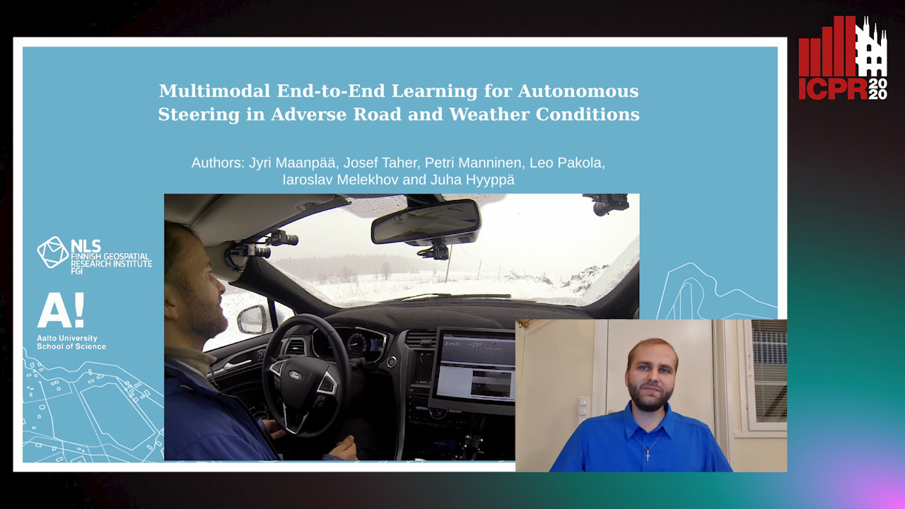
Auto-TLDR; End-to-End Learning for Autonomous Steering in Adverse Road and Weather Conditions with Lidar Data

Slides Poster

Autonomous driving is challenging in adverse road and weather conditions in which there might not be lane lines, the road might be covered in snow and the visibility might be poor. We extend the previous work on end-to-end learning for autonomous steering to operate in these adverse real-life conditions with multimodal data. We collected 28 hours of driving data in several road and weather conditions and trained convolutional neural networks to predict the car steering wheel angle from front-facing color camera images and lidar range and reflectance data. We compared the CNN model performances based on the different modalities and our results show that the lidar modality improves the performances of different multimodal sensor-fusion models. We also performed on-road tests with different models and they support this observation.

Similar papers

Holistic Grid Fusion Based Stop Line Estimation

Runsheng Xu, Faezeh Tafazzoli, Li Zhang, Timo Rehfeld, Gunther Krehl, Arunava Seal

Responsive image

Auto-TLDR; Fused Multi-Sensory Data for Stop Lines Detection in Intersection Scenarios

Slides Similar

Intersection scenarios provide the most complex traffic situations in Autonomous Driving and Driving Assistance Systems. Knowing where to stop in advance in an intersection is an essential parameter in controlling the longitudinal velocity of the vehicle. Most of the existing methods in literature solely use cameras to detect stop lines, which is typically not sufficient in terms of detection range. To address this issue, we propose a method that takes advantage of fused multi-sensory data including stereo camera and lidar as input and utilizes a carefully designed convolutional neural network architecture to detect stop lines. Our experiments show that the proposed approach can improve detection range compared to camera data alone, works under heavy occlusion without observing the ground markings explicitly, is able to predict stop lines for all lanes and allows detection at a distance up to 50 meters.

PolyLaneNet: Lane Estimation Via Deep Polynomial Regression

Talles Torres, Rodrigo Berriel, Thiago Paixão, Claudine Badue, Alberto F. De Souza, Thiago Oliveira-Santos

Responsive image

Auto-TLDR; Real-Time Lane Detection with Deep Polynomial Regression

Slides Poster Similar

One of the main factors that contributed to the large advances in autonomous driving is the advent of deep learning. For safer self-driving vehicles, one of the problems that has yet to be solved completely is lane detection. Since methods for this task have to work in real time (+30 FPS), they not only have to be effective (i.e., have high accuracy) but they also have to be efficient (i.e., fast). In this work, we present a novel method for lane detection that uses as input an image from a forward-looking camera mounted in the vehicle and outputs polynomials representing each lane marking in the image, via deep polynomial regression. The proposed method is shown to be competitive with existing state-of-the-art methods in the TuSimple dataset, while maintaining its efficiency (115 FPS). Additionally, extensive qualitative results on two additional public datasets are presented, alongside with limitations in the evaluation metrics used by recent works for lane detection. Finally, we provide source code and trained models that allow others to replicate all the results shown in this paper, which is surprisingly rare in state-of-the-art lane detection methods.

Vehicle Lane Merge Visual Benchmark

Kai Cordes, Hellward Broszio

Responsive image

Auto-TLDR; A Benchmark for Automated Cooperative Maneuvering Using Multi-view Video Streams and Ground Truth Vehicle Description

Slides Poster Similar

Automated driving is regarded as the most promising technology for improving road safety in the future. In this context, connected vehicles have an important role regarding their ability to perform cooperative maneuvers for challenging traffic situations. We propose a benchmark for automated cooperative maneuvers. The targeted cooperative maneuver is the vehicle lane merge where a vehicle on the acceleration lane merges into the traffic of a motorway. The benchmark enables the evaluation of vehicle localization approaches as well as the study of cooperative maneuvers. It consists of temporally synchronized multi-view video streams, highly accurate camera calibration, and ground truth vehicle descriptions, including position, heading, speed, and shape. For benchmark generation, the lane merge maneuver is performed by human drivers on a test track, resulting in 120 lane merge data sets with various traffic situations and video recording conditions.

CARRADA Dataset: Camera and Automotive Radar with Range-Angle-Doppler Annotations

Arthur Ouaknine, Alasdair Newson, Julien Rebut, Florence Tupin, Patrick Pérez

Responsive image

Auto-TLDR; CARRADA: A dataset of synchronized camera and radar recordings with range-angle-Doppler annotations for autonomous driving

Slides Poster Similar

High quality perception is essential for autonomous driving (AD) systems. To reach the accuracy and robustness that are required by such systems, several types of sensors must be combined. Currently, mostly cameras and laser scanners (lidar) are deployed to build a representation of the world around the vehicle. While radar sensors have been used for a long time in the automotive industry, they are still under-used for AD despite their appealing characteristics (notably, their ability to measure the relative speed of obstacles and to operate even in adverse weather conditions). To a large extent, this situation is due to the relative lack of automotive datasets with real radar signals that are both raw and annotated. In this work, we introduce CARRADA, a dataset of synchronized camera and radar recordings with range-angle-Doppler annotations. We also present a semi-automatic annotation approach, which was used to annotate the dataset, and a radar semantic segmentation baseline, which we evaluate on several metrics. Both our code and dataset will be released.

Real-Time End-To-End Lane ID Estimation Using Recurrent Networks

Ibrahim Halfaoui, Fahd Bouzaraa, Onay Urfalioglu

Responsive image

Auto-TLDR; Real-Time, Vision-Only Lane Identification Using Monocular Camera

Slides Poster Similar

Acquiring information about the road lane structure is a crucial step for autonomous navigation. To this end, several approaches tackle this task from different perspectives such as lane marking detection or semantic lane segmentation.However, to the best of our knowledge, there is yet no purely vision based end-to-end solution to answer the precise question: How to estimate the relative number or "ID" of the current driven lane within a multi-lane road or a highway? In this work, we propose a real-time, vision-only (i.e. monocular camera) solution to the problem based on a dual left-right convention. We interpret this task as a classification problem by limiting the maximum number of lane candidates to eight. Our approach is designed to meet low-complexity specifications and limited runtime requirements. It harnesses the temporal dimension inherent to the input sequences to improve upon high complexity state-of-the-art models. We achieve more than 95% accuracy on a challenging test set with extreme conditions and different routes.

Temporal Pulses Driven Spiking Neural Network for Time and Power Efficient Object Recognition in Autonomous Driving

Wei Wang, Shibo Zhou, Jingxi Li, Xiaohua Li, Junsong Yuan, Zhanpeng Jin

Responsive image

Auto-TLDR; Spiking Neural Network for Real-Time Object Recognition on Temporal LiDAR Pulses

Slides Poster Similar

Accurate real-time object recognition from sensory data has long been a crucial and challenging task for autonomous driving. Even though deep neural networks (DNNs) have been widely applied in this area, their considerable processing latency, power consumption as well as computational complexity have been challenging issues for real-time autonomous driving applications. In this paper, we propose an approach to address the real-time object recognition problem utilizing spiking neural networks (SNNs). The proposed SNN model works directly with raw temporal LiDAR pulses without the pulse-to-point cloud preprocessing procedure, which can significantly reduce delay and power consumption. Being evaluated on various datasets derived from LiDAR and dynamic vision sensor (DVS), including Sim LiDAR, KITTI, and DVS-barrel, our proposed model has shown remarkable time and power efficiency, while achieving comparable recognition performance as the state-of-the-art methods. This paper highlights the SNN's great potentials in autonomous driving and related applications. To the best of our knowledge, this is the first attempt to use SNN to directly perform time and energy efficient object recognition on temporal LiDAR pulses in the setting of autonomous driving.

A Bayesian Approach to Reinforcement Learning of Vision-Based Vehicular Control

Zahra Gharaee, Karl Holmquist, Linbo He, Michael Felsberg

Responsive image

Auto-TLDR; Bayesian Reinforcement Learning for Autonomous Driving

Slides Poster Similar

In this paper, we present a state-of-the-art reinforcement learning method for autonomous driving. Our approach employs temporal difference learning in a Bayesian framework to learn vehicle control signals from sensor data. The agent has access to images from a forward facing camera, which are pre-processed to generate semantic segmentation maps. We trained our system using both ground truth and estimated semantic segmentation input. Based on our observations from a large set of experiments, we conclude that training the system on ground truth input data leads to better performance than training the system on estimated input even if estimated input is used for evaluation. The system is trained and evaluated in a realistic simulated urban environment using the CARLA simulator. The simulator also contains a benchmark that allows for comparing to other systems and methods. The required training time of the system is shown to be lower and the performance on the benchmark superior to competing approaches.

Ghost Target Detection in 3D Radar Data Using Point Cloud Based Deep Neural Network

Mahdi Chamseddine, Jason Rambach, Oliver Wasenmüler, Didier Stricker

Responsive image

Auto-TLDR; Point Based Deep Learning for Ghost Target Detection in 3D Radar Point Clouds

Slides Poster Similar

Ghost targets are targets that appear at wrong locations in radar data and are caused by the presence of multiple indirect reflections between the target and the sensor. In this work, we introduce the first point based deep learning approach for ghost target detection in 3D radar point clouds. This is done by extending the PointNet network architecture by modifying its input to include radar point features beyond location and introducing skip connetions. We compare different input modalities and analyze the effects of the changes we introduced. We also propose an approach for automatic labeling of ghost targets 3D radar data using lidar as reference. The algorithm is trained and tested on real data in various driving scenarios and the tests show promising results in classifying real and ghost radar targets.

Attention Based Coupled Framework for Road and Pothole Segmentation

Shaik Masihullah, Ritu Garg, Prerana Mukherjee, Anupama Ray

Responsive image

Auto-TLDR; Few Shot Learning for Road and Pothole Segmentation on KITTI and IDD

Slides Poster Similar

In this paper, we propose a novel attention based coupled framework for road and pothole segmentation. In many developing countries as well as in rural areas, the drivable areas are neither well-defined, nor well-maintained. Under such circumstances, an Advance Driver Assistant System (ADAS) is needed to assess the drivable area and alert about the potholes ahead to ensure vehicle safety. Moreover, this information can also be used in structured environments for assessment and maintenance of road health. We demonstrate few shot learning approach for pothole detection to leverage accuracy even with fewer training samples. We report the exhaustive experimental results for road segmentation on KITTI and IDD datasets. We also present pothole segmentation on IDD.

RISEdb: A Novel Indoor Localization Dataset

Carlos Sanchez Belenguer, Erik Wolfart, Álvaro Casado Coscollá, Vitor Sequeira

Responsive image

Auto-TLDR; Indoor Localization Using LiDAR SLAM and Smartphones: A Benchmarking Dataset

Slides Poster Similar

In this paper we introduce a novel public dataset for developing and benchmarking indoor localization systems. We have selected and 3D mapped a set of representative indoor environments including a large office building, a conference room, a workshop, an exhibition area and a restaurant. Our acquisition pipeline is based on a portable LiDAR SLAM backpack to map the buildings and to accurately track the pose of the user as it moves freely inside them. We introduce the calibration procedures that enable us to acquire and geo-reference live data coming from different independent sensors rigidly attached to the backpack. This has allowed us to collect long sequences of spherical and stereo images, together with all the sensor readings coming from a consumer smartphone and locate them inside the map with centimetre accuracy. The dataset addresses many of the limitations of existing indoor localization datasets regarding the scale and diversity of the mapped buildings; the number of acquired sequences under varying conditions; the accuracy of the ground-truth trajectory; the availability of a detailed 3D model and the availability of different sensor types. It enables the benchmarking of existing and the development of new indoor localization approaches, in particular for deep learning based systems that require large amounts of labeled training data.

Multiple Future Prediction Leveraging Synthetic Trajectories

Lorenzo Berlincioni, Federico Becattini, Lorenzo Seidenari, Alberto Del Bimbo

Responsive image

Auto-TLDR; Synthetic Trajectory Prediction using Markov Chains

Slides Poster Similar

Trajectory prediction is an important task, especially in autonomous driving. The ability to forecast the position of other moving agents can yield to an effective planning, ensuring safety for the autonomous vehicle as well for the observed entities. In this work we propose a data driven approach based on Markov Chains to generate synthetic trajectories, which are useful for training a multiple future trajectory predictor. The advantages are twofold: on the one hand synthetic samples can be used to augment existing datasets and train more effective predictors; on the other hand, it allows to generate samples with multiple ground truths, corresponding to diverse equally likely outcomes of the observed trajectory. We define a trajectory prediction model and a loss that explicitly address the multimodality of the problem and we show that combining synthetic and real data leads to prediction improvements, obtaining state of the art results.

RONELD: Robust Neural Network Output Enhancement for Active Lane Detection

Zhe Ming Chng, Joseph Mun Hung Lew, Jimmy Addison Lee

Responsive image

Auto-TLDR; Real-Time Robust Neural Network Output Enhancement for Active Lane Detection

Slides Poster Similar

Accurate lane detection is critical for navigation in autonomous vehicles, particularly the active lane which demarcates the single road space that the vehicle is currently traveling on. Recent state-of-the-art lane detection algorithms utilize convolutional neural networks (CNNs) to train deep learning models on popular benchmarks such as TuSimple and CULane. While each of these models works particularly well on train and test inputs obtained from the same dataset, the performance drops significantly on unseen datasets of different environments. In this paper, we present a real-time robust neural network output enhancement for active lane detection (RONELD) method to identify, track, and optimize active lanes from deep learning probability map outputs. We first adaptively extract lane points from the probability map outputs, followed by detecting curved and straight lanes before using weighted least squares linear regression on straight lanes to fix broken lane edges resulting from fragmentation of edge maps in real images. Lastly, we hypothesize true active lanes through tracking preceding frames. Experimental results demonstrate an up to two-fold increase in accuracy using RONELD on cross-dataset validation tests.

NetCalib: A Novel Approach for LiDAR-Camera Auto-Calibration Based on Deep Learning

Shan Wu, Amnir Hadachi, Damien Vivet, Yadu Prabhakar

Responsive image

Auto-TLDR; Automatic Calibration of LiDAR and Cameras using Deep Neural Network

Slides Poster Similar

A fusion of LiDAR and cameras have been widely used in many robotics applications such as classification, segmentation, object detection, and autonomous driving. It is essential that the LiDAR sensor can measure distances accurately, which is a good complement to the cameras. Hence, calibrating sensors before deployment is a mandatory step. The conventional methods include checkerboards, specific patterns, or human labeling, which is trivial and human-labor extensive if we do the same calibration process every time. The main propose of this research work is to build a deep neural network that is capable of automatically finding the geometric transformation between LiDAR and cameras. The results show that our model manages to find the transformations from randomly sampled artificial errors. Besides, our work is open-sourced for the community to fully utilize the advances of the methodology for developing more the approach, initiating collaboration, and innovation in the topic.

A Fine-Grained Dataset and Its Efficient Semantic Segmentation for Unstructured Driving Scenarios

Kai Andreas Metzger, Peter Mortimer, Hans J "Joe" Wuensche

Responsive image

Auto-TLDR; TAS500: A Semantic Segmentation Dataset for Autonomous Driving in Unstructured Environments

Slides Poster Similar

Research in autonomous driving for unstructured environments suffers from a lack of semantically labeled datasets compared to its urban counterpart. Urban and unstructured outdoor environments are challenging due to the varying lighting and weather conditions during a day and across seasons. In this paper, we introduce TAS500, a novel semantic segmentation dataset for autonomous driving in unstructured environments. TAS500 offers fine-grained vegetation and terrain classes to learn drivable surfaces and natural obstacles in outdoor scenes effectively. We evaluate the performance of modern semantic segmentation models with an additional focus on their efficiency. Our experiments demonstrate the advantages of fine-grained semantic classes to improve the overall prediction accuracy, especially along the class boundaries. The dataset, code, and pretrained model are available online.

Extending Single Beam Lidar to Full Resolution by Fusing with Single Image Depth Estimation

Yawen Lu, Yuxing Wang, Devarth Parikh, Guoyu Lu

Responsive image

Auto-TLDR; Self-supervised LIDAR for Low-Cost Depth Estimation

Slides Similar

Depth estimation is playing an important role in indoor and outdoor scene understanding, autonomous driving, augmented reality and many other tasks. Vehicles and robotics are able to use active illumination sensors such as LIDAR to receive high precision depth estimation. However, high-resolution Lidars are usually too expensive, which limits its massive production on various applications. Though single beam LIDAR enjoys the benefits of low cost, one beam depth sensing is not usually sufficient to perceive the surrounding environment in many scenarios. In this paper, we propose a learning-based framework to explore to replicate similar or even higher performance as costly LIDARs with our designed self-supervised network and a low-cost single-beam LIDAR. After the accurate calibration with a visible camera, the single beam LIDAR can adjust the scale uncertainty of the depth map estimated by the visible camera. The adjusted depth map enjoys the benefits of high resolution and sensing accuracy as high beam LIDAR and maintains low-cost as single beam LIDAR. Thus we can achieve similar sensing effect of high beam LIDAR with more than a 50-100 times cheaper price (e.g., \$80000 Velodyne HDL-64E LIDAR v.s. \$1000 SICK TIM-781 2D LIDAR and normal camera). The proposed approach is verified on our collected dataset and public dataset with superior depth-sensing performance.

Street-Map Based Validation of Semantic Segmentation in Autonomous Driving

Laura Von Rueden, Tim Wirtz, Fabian Hueger, Jan David Schneider, Nico Piatkowski, Christian Bauckhage

Responsive image

Auto-TLDR; Semantic Segmentation Mask Validation Using A-priori Knowledge from Street Maps

Slides Poster Similar

Artificial intelligence for autonomous driving must meet strict requirements on safety and robustness, which motivates the thorough validation of learned models. However, current validation approaches mostly require ground truth data and are thus both cost-intensive and limited in their applicability. We propose to overcome these limitations by a model agnostic validation using a-priori knowledge from street maps. In particular, we show how to validate semantic segmentation masks and demonstrate the potential of our approach using OpenStreetMap. We introduce validation metrics that indicate false positive or negative road segments. Besides the validation approach, we present a method to correct the vehicle's GPS position so that a more accurate localization can be used for the street map based validation. Lastly, we present quantitative results on the Cityscapes dataset indicating that our validation approach can indeed uncover errors in semantic segmentation masks.

Visual Prediction of Driver Behavior in Shared Road Areas

Peter Gawronski, Darius Burschka

Responsive image

Auto-TLDR; Predicting Vehicle Behavior in Shared Road Segment Intersections Using Topological Knowledge

Slides Poster Similar

We propose a framework to analyze and predict vehicles behavior within shared road segments like intersections or at narrow passages. The system first identifies critical interaction regions based on topological knowledge. It then checks possible colliding trajectories from the current state of vehicles in the scene, defined by overlapping occupation times in road segments. For each possible interaction area, it analyzes the behavioral profile of both vehicles. Depending on right of way and (unpredictable) behavior parameters, different outcomes are expected and will be tested against input. The interaction between vehicles is analyzed over a short time horizon based on an initial action from one vehicle and the reaction by the other. The vehicle to yield most often performs the first action and the response of the opponent vehicle is measured after a reaction time. The observed reaction is classified by attention, if there was a reaction at all, and the collaboration of the opponent vehicle, whether it helps to resolve the situation or hinders it. The output is a classification of behavior of involved vehicles in terms of active participation in the interaction and assertiveness of driving style in terms of collaborative or disruptive behavior. The additional knowledge is used to refine the prediction of intention and outcome of a scene, which is then compared to the current status to catch unexpected behavior. The applicability of the concept and ideas of the approach is validated on scenarios from the recent Intersection Drone (inD) data set.

P2D: A Self-Supervised Method for Depth Estimation from Polarimetry

Marc Blanchon, Desire Sidibe, Olivier Morel, Ralph Seulin, Daniel Braun, Fabrice Meriaudeau

Responsive image

Auto-TLDR; Polarimetric Regularization for Monocular Depth Estimation

Slides Poster Similar

Monocular depth estimation is a recurring subject in the field of computer vision. Its ability to describe scenes via a depth map while reducing the constraints related to the formulation of perspective geometry tends to favor its use. However, despite the constant improvement of algorithms, most methods exploit only colorimetric information. Consequently, robustness to events to which the modality is not sensitive to, like specularity or transparency, is neglected. In response to this phenomenon, we propose using polarimetry as an input for a self-supervised monodepth network. Therefore, we propose exploiting polarization cues to encourage accurate reconstruction of scenes. Furthermore, we include a term of polarimetric regularization to state-of-the-art method to take specific advantage of the data. Our method is evaluated both qualitatively and quantitatively demonstrating that the contribution of this new information as well as an enhanced loss function improves depth estimation results, especially for specular areas.

Surface Material Dataset for Robotics Applications (SMDRA): A Dataset with Friction Coefficient and RGB-D for Surface Segmentation

Donghun Noh, Hyunwoo Nam, Min Sung Ahn, Hosik Chae, Sangjoon Lee, Kyle Gillespie, Dennis Hong

Responsive image

Auto-TLDR; A Surface Material Dataset for Robotics Applications

Slides Poster Similar

In this paper, we introduce the Surface Material Dataset for Robotics Applications (SMDRA), a collection of RGB color image, depth data, and pixel-wise friction coefficient data of 10 different materials for computer vision research specifically with robotics applications in mind that require physical contact between the robot and its environment such as robotic manipulators or walking robots. These selected surface materials are both easily accessible around our daily lives and cover a wide range of friction coefficients. Our dataset is unique in that while there is an abundance of RGB-D data due to the popularization of imaging sensors, additional pixel-wise aligned data of a different modality are not readily available. The depth data is collected by an active stereo camera which has shown promise on a variety of different robotic applications. In addition, this dataset is greatly expanded with friction coefficient data. Similarly to humans, this additional information can be helpful in ensuing proper decision making in tasks ranging from grasping orientation and strength to path determination in an unstructured environment. A newly developed friction measuring device was used to obtain this data. We verify that existing Convolutional Neural Network (CNN) architectures, the Fully Convolutional Network (FCN) and U-Net, can be trained on the SMDRA. This result demonstrates that the SMDRA can be utilized to train a neural network model for segmentation and these different modes are not just additional information, but valuable modes that researchers can incorporate and exploit when applying computer vision algorithms on robotic platforms.

Visual Localization for Autonomous Driving: Mapping the Accurate Location in the City Maze

Dongfang Liu, Yiming Cui, Xiaolei Guo, Wei Ding, Baijian Yang, Yingjie Chen

Responsive image

Auto-TLDR; Feature Voting for Robust Visual Localization in Urban Settings

Slides Poster Similar

Accurate localization is a foundational capacity, required for autonomous vehicles to accomplish other tasks such as navigation or path planning. It is a common practice for vehicles to use GPS to acquire location information. However, the application of GPS can result in severe challenges when vehicles run within the inner city where different kinds of structures may shadow the GPS signal and lead to inaccurate location results. To address the localization challenges of urban settings, we propose a novel feature voting technique for visual localization. Different from the conventional front-view-based method, our approach employs views from three directions (front, left, and right) and thus significantly improves the robustness of location prediction. In our work, we craft the proposed feature voting method into three state-of-the-art visual localization networks and modify their architectures properly so that they can be applied for vehicular operation. Extensive field test results indicate that our approach can predict location robustly even in challenging inner-city settings. Our research sheds light on using the visual localization approach to help autonomous vehicles to find accurate location information in a city maze, within a desirable time constraint.

Single-Modal Incremental Terrain Clustering from Self-Supervised Audio-Visual Feature Learning

Reina Ishikawa, Ryo Hachiuma, Akiyoshi Kurobe, Hideo Saito

Responsive image

Auto-TLDR; Multi-modal Variational Autoencoder for Terrain Type Clustering

Slides Poster Similar

The key to an accurate understanding of terrain is to extract the informative features from the multi-modal data obtained from different devices. Sensors, such as RGB cameras, depth sensors, vibration sensors, and microphones, are used as the multi-modal data. Many studies have explored ways to use them, especially in the robotics field. Some papers have successfully introduced single-modal or multi-modal methods. However, in practice, robots can be faced with extreme conditions; microphones do not work well in the crowded scenes, and an RGB camera cannot capture terrains well in the dark. In this paper, we present a novel framework using the multi-modal variational autoencoder and the Gaussian mixture model clustering algorithm on image data and audio data for terrain type clustering. Our method enables the terrain type clustering even if one of the modalities (either image or audio) is missing at the test-time. We evaluated the clustering accuracy with a conventional multi-modal terrain type clustering method and we conducted ablation studies to show the effectiveness of our approach.

Anomaly Detection, Localization and Classification for Railway Inspection

Riccardo Gasparini, Andrea D'Eusanio, Guido Borghi, Stefano Pini, Giuseppe Scaglione, Simone Calderara, Eugenio Fedeli, Rita Cucchiara

Responsive image

Auto-TLDR; Anomaly Detection and Localization using thermal images in the lowlight environment

Slides Similar

The ability to detect, localize and classify objects that are anomalies is a challenging task in the computer vision community. In this paper, we tackle these tasks developing a framework to automatically inspect the railway during the night. Specifically, it is able to predict the presence, the image coordinates and the class of obstacles. To deal with the lowlight environment, the framework is based on thermal images and consists of three different modules that address the problem of detecting anomalies, predicting their image coordinates and classifying them. Moreover, due to the absolute lack of publicly released datasets collected in the railway context for anomaly detection, we introduce a new multi-modal dataset, acquired from a rail drone, used to evaluate the proposed framework. Experimental results confirm the accuracy of the framework and its suitability, in terms of computational load, performance, and inference time, to be implemented on a self-powered inspection system.

Wireless Localisation in WiFi Using Novel Deep Architectures

Peizheng Li, Han Cui, Aftab Khan, Usman Raza, Robert Piechocki, Angela Doufexi, Tim Farnham

Responsive image

Auto-TLDR; Deep Neural Network for Indoor Localisation of WiFi Devices in Indoor Environments

Slides Poster Similar

This paper studies the indoor localisation of WiFi devices based on a commodity chipset and standard channel sounding. First, we present a novel shallow neural network (SNN) in which features are extracted from the channel state information (CSI) corresponding to WiFi subcarriers received on different antennas and used to train the model. The single layer architecture of this localisation neural network makes it lightweight and easy-to-deploy on devices with stringent constraints on computational resources. We further investigate for localisation the use of deep learning models and design novel architectures for convolutional neural network (CNN) and long-short term memory (LSTM). We extensively evaluate these localisation algorithms for continuous tracking in indoor environments. Experimental results prove that even an SNN model, after a careful handcrafted feature extraction, can achieve accurate localisation. Meanwhile, using a well-organised architecture, the neural network models can be trained directly with raw data from the CSI and localisation features can be automatically extracted to achieve accurate position estimates. We also found that the performance of neural network-based methods are directly affected by the number of anchor access points (APs) regardless of their structure. With three APs, all neural network models proposed in this paper can obtain localisation accuracy of around 0.5 metres. In addition the proposed deep NN architecture reduces the data pre-processing time by 6.5 hours compared with a shallow NN using the data collected in our testbed. In the deployment phase, the inference time is also significantly reduced to 0.1 ms per sample. We also demonstrate the generalisation capability of the proposed method by evaluating models using different target movement characteristics to the ones in which they were trained.

Weight Estimation from an RGB-D Camera in Top-View Configuration

Marco Mameli, Marina Paolanti, Nicola Conci, Filippo Tessaro, Emanuele Frontoni, Primo Zingaretti

Responsive image

Auto-TLDR; Top-View Weight Estimation using Deep Neural Networks

Slides Poster Similar

The development of so-called soft-biometrics aims at providing information related to the physical and behavioural characteristics of a person. This paper focuses on bodyweight estimation based on the observation from a top-view RGB-D camera. In fact, the capability to estimate the weight of a person can be of help in many different applications, from health-related scenarios to business intelligence and retail analytics. To deal with this issue, a TVWE (Top-View Weight Estimation) framework is proposed with the aim of predicting the weight. The approach relies on the adoption of Deep Neural Networks (DNNs) that have been trained on depth data. Each network has also been modified in its top section to replace classification with prediction inference. The performance of five state-of-art DNNs has been compared, namely VGG16, ResNet, Inception, DenseNet and Efficient-Net. In addition, a convolutional auto-encoder has also been included for completeness. Considering the limited literature in this domain, the TVWE framework has been evaluated on a new publicly available dataset: “VRAI Weight estimation Dataset”, which also collects, for each subject, labels related to weight, gender, and height. The experimental results have demonstrated that the proposed methods are suitable for this task, bringing different and significant insights for the application of the solution in different domains.

Lane Detection Based on Object Detection and Image-To-Image Translation

Hiroyuki Komori, Kazunori Onoguchi

Responsive image

Auto-TLDR; Lane Marking and Road Boundary Detection from Monocular Camera Images using Inverse Perspective Mapping

Slides Poster Similar

In this paper, we propose a method to detect various types of lane markings and road boundaries simultaneously from a monocular camera image. This method detects lane markings and road boundaries in IPM images obtained by the Inverse Perspective Mapping of input images. First, bounding boxes surrounding a lane marking or the road boundary are extracted by the object detection network. At the same time, these areas are labelled with a solid line, a dashed line, a zebra line, a curb, a grass, a sidewall and so on. Next, in each bounding box, lane marking boundaries or road boundaries are drawn by the image-to-image translation network. We use YOLOv3 for the object detection and pix2pix for the image translation. We create our own datasets including various types of lane markings and road boundaries and evaluate our approach using these datasets qualitatively and quantitatively.

Real-Time Drone Detection and Tracking with Visible, Thermal and Acoustic Sensors

Fredrik Svanström, Cristofer Englund, Fernando Alonso-Fernandez

Responsive image

Auto-TLDR; Automatic multi-sensor drone detection using sensor fusion

Slides Poster Similar

This paper explores the process of designing an automatic multi-sensor drone detection system. Besides the common video and audio sensors, the system also includes a thermal infrared camera, which is shown to be a feasible solution to the drone detection task. Even with slightly lower resolution, the performance is just as good as a camera in visible range. The detector performance as a function of the sensor-to-target distance is also investigated. In addition, using sensor fusion, the system is made more robust than the individual sensors, helping to reduce false detections. To counteract the lack of public datasets, a novel video dataset containing 650 annotated infrared and visible videos of drones, birds, airplanes and helicopters is also presented. The database is complemented with an audio dataset of the classes drones, helicopters and background noise.

Improving Robotic Grasping on Monocular Images Via Multi-Task Learning and Positional Loss

William Prew, Toby Breckon, Magnus Bordewich, Ulrik Beierholm

Responsive image

Auto-TLDR; Improving grasping performance from monocularcolour images in an end-to-end CNN architecture with multi-task learning

Slides Poster Similar

In this paper we introduce two methods of improv-ing real-time objecting grasping performance from monocularcolour images in an end-to-end CNN architecture. The first isthe addition of an auxiliary task during model training (multi-task learning). Our multi-task CNN model improves graspingperformance from a baseline average of 72.04% to 78.14% onthe large Jacquard grasping dataset when performing a supple-mentary depth reconstruction task. The second is introducinga positional loss function that emphasises loss per pixel forsecondary parameters (gripper angle and width) only on points ofan object where a successful grasp can take place. This increasesperformance from a baseline average of 72.04% to 78.92% aswell as reducing the number of training epochs required. Thesemethods can be also performed in tandem resulting in a furtherperformance increase to 79.12%, while maintaining sufficientinference speed to enable processing at 50FPS

Polarimetric Image Augmentation

Marc Blanchon, Fabrice Meriaudeau, Olivier Morel, Ralph Seulin, Desire Sidibe

Responsive image

Auto-TLDR; Polarimetric Augmentation for Deep Learning in Robotics Applications

Poster Similar

This paper deals with new augmentation methods for an unconventional imaging modality sensitive to the physics of the observed scene called polarimetry. In nature, polarized light is obtained by reflection or scattering. Robotics applications in urban environments are subject to many obstacles that can be specular and therefore provide polarized light. These areas are prone to segmentation errors using standard modalities but could be solved using information carried by the polarized light. Deep Convolutional Neural Networks (DCNNs) have shown excellent segmentation results, but require a significant amount of data to achieve best performances. The lack of data is usually overcomed by using augmentation methods. However, unlike RGB images, polarization images are not only scalar (intensity) images and standard augmentation techniques cannot be applied straightforwardly. We propose enhancing deep learning models through a regularized augmentation procedure applied to polarimetric data in order to characterize scenes more effectively under challenging conditions. We subsequently observe an average of 18.1% improvement in IoU between not augmented and regularized training procedures on real world data.

Yolo+FPN: 2D and 3D Fused Object Detection with an RGB-D Camera

Ya Wang

Responsive image

Auto-TLDR; Yolo+FPN: Combining 2D and 3D Object Detection for Real-Time Object Detection

Slides Poster Similar

In this paper we propose a new deep neural network system, called Yolo+FPN, which fuses both 2D and 3D object detection algorithms to achieve better real-time object detection results and faster inference speed, to be used on real robots. Finding an optimized fusion strategy to efficiently combine 3D object detection with 2D detection information is useful and challenging for both indoor and outdoor robots. In order to satisfy real-time requirements, a trade-off between accuracy and efficiency is needed. We not only have improved training and test accuracies and lower mean losses on the KITTI object detection benchmark, but also achieve better average precision on 3D detection of all classes in three levels of difficulty. Also, we implemented Yolo+FPN system using an RGB-D camera, and compared the speed of 2D and 3D object detection using different GPUs. For the real implementation of both indoor and outdoor scenes, we focus on person detection, which is the most challenging and important among the three classes.

Localization of Unmanned Aerial Vehicles in Corridor Environments Using Deep Learning

Ram Padhy, Shahzad Ahmad, Sachin Verma, Sambit Bakshi, Pankaj Kumar Sa

Responsive image

Auto-TLDR; A monocular vision assisted localization algorithm for indoor corridor environments

Slides Poster Similar

We propose a monocular vision assisted localization algorithm, that will help a UAV navigate safely in indoor corridor environments. Always, the aim is to navigate the UAV through a corridor in the forward direction by keeping it at the center with no orientation either to the left or right side. The algorithm makes use of the RGB image, captured from the UAV front camera, and passes it through a trained Deep Neural Network (DNN) to predict the position of the UAV as either on the left or center or right side of the corridor. Depending upon the divergence of the UAV with respect to an imaginary central line, known as the central bisector line (CBL) of the corridor, a suitable command is generated to bring the UAV to the center. When the UAV is at the center of the corridor, a new image is passed through another trained DNN to predict the orientation of the UAV with respect to the CBL of the corridor. If the UAV is either left or right tilted, an appropriate command is generated to rectify the orientation. We also propose a new corridor dataset, named UAVCorV1, which contains images as captured by the UAV front camera when the UAV is at all possible locations of a variety of corridors. An exhaustive set of experiments in different corridors reveal the efficacy of the proposed algorithm.

RWF-2000: An Open Large Scale Video Database for Violence Detection

Ming Cheng, Kunjing Cai, Ming Li

Responsive image

Auto-TLDR; Flow Gated Network for Violence Detection in Surveillance Cameras

Slides Poster Similar

In recent years, surveillance cameras are widely deployed in public places, and the general crime rate has been reduced significantly due to these ubiquitous devices. Usually, these cameras provide cues and evidence after crimes were conducted, while they are rarely used to prevent or stop criminal activities in time. It is both time and labor consuming to manually monitor a large amount of video data from surveillance cameras. Therefore, automatically recognizing violent behaviors from video signals becomes essential. In this paper, we summarize several existing video datasets for violence detection and propose a new video dataset with 2,000 videos all captured by surveillance cameras in real-world scenes. Also, we present a new method that utilizes both the merits of 3D-CNNs and optical flow, namely Flow Gated Network. The proposed approach obtains an accuracy of 87.25% on the test set of our proposed RWF-2000 database. The proposed database and source codes of this paper are currently open to access.

Semantic Segmentation for Pedestrian Detection from Motion in Temporal Domain

Guo Cheng, Jiang Yu Zheng

Responsive image

Auto-TLDR; Motion Profile: Recognizing Pedestrians along with their Motion Directions in a Temporal Way

Slides Poster Similar

In autonomous driving, state-of-the-art methods detect pedestrian through appearance in 2-D spatial images. However, these approaches are typically time-consuming because of the complexity of algorithms to cope with large variations in shape, pose, action, and illumination. They also fall short of capturing temporal continuity in motion trace. In a completely different approach, this work recognizes pedestrians along with their motion directions in a temporal way. By projecting a driving video to a 2-D temporal image called Motion Profile (MP), we can robustly distinguish pedestrian in motion and standing-still against smooth background motion. To ensure non-redundant data processing of deep network on a compact motion profile further, a novel temporal-shift memory (TSM) model is developed to perform deep learning of sequential input in linear processing time. In experiments containing various pedestrian motion from sensors such as video and LiDAR, we demonstrate that, with the data size around 3/720th of video volume, this motion-based method can reach the detecting rate of pedestrians at 90% in near and mid-range on the road. With a super-fast processing speed and good accuracy, this method is promising for intelligent vehicles.

Loop-closure detection by LiDAR scan re-identification

Jukka Peltomäki, Xingyang Ni, Jussi Puura, Joni-Kristian Kamarainen, Heikki Juhani Huttunen

Responsive image

Auto-TLDR; Loop-Closing Detection from LiDAR Scans Using Convolutional Neural Networks

Slides Poster Similar

In this work, loop-closure detection from LiDAR scans is defined as an image re-identification problem. Re-identification is performed by computing Euclidean distances of a query scan to a gallery set of previous scans. The distances are computed in a feature embedding space where the scans are mapped by a convolutional neural network (CNN). The network is trained using the triplet loss training strategy. In our experiments we compare different backbone networks, variants of the triplet loss and generic and LiDAR specific data augmentation techniques. With a realistic indoor dataset the best architecture obtains the mean average precision (mAP) above 90%.

End-To-End Deep Learning Methods for Automated Damage Detection in Extreme Events at Various Scales

Yongsheng Bai, Alper Yilmaz, Halil Sezen

Responsive image

Auto-TLDR; Robust Mask R-CNN for Crack Detection in Extreme Events

Slides Poster Similar

Robust Mask R-CNN (Mask Regional Convolutional Neural Network) methods are proposed and tested for automatic detection of cracks on structures or their components that may be damaged during extreme events, such as earth-quakes. We curated a new dataset with 2,021 labeled images for training and validation and aimed to find end-to-end deep neural networks for crack detection in the field. With data augmentation and parameters fine-tuning, Path Aggregation Network (PANet) with spatial attention mechanisms and High-resolution Network (HRNet) are introduced into Mask R-CNNs. The tests on three public datasets with low- or high-resolution images demonstrate that the proposed methods can achieve a big improvement over alternative networks, so the proposed method may be sufficient for crack detection for a variety of scales in real applications.

Exploring Severe Occlusion: Multi-Person 3D Pose Estimation with Gated Convolution

Renshu Gu, Gaoang Wang, Jenq-Neng Hwang

Responsive image

Auto-TLDR; 3D Human Pose Estimation for Multi-Human Videos with Occlusion

Slides Similar

3D human pose estimation (HPE) is crucial in human behavior analysis, augmented reality/virtual reality (AR/VR) applications, and self-driving industry. Videos that contain multiple potentially occluded people captured from freely moving monocular cameras are very common in real-world scenarios, while 3D HPE for such scenarios is quite challenging, partially because there is a lack of such data with accurate 3D ground truth labels in existing datasets. In this paper, we propose a temporal regression network with a gated convolution module to transform 2D joints to 3D and recover the missing occluded joints in the meantime. A simple yet effective localization approach is further conducted to transform the normalized pose to the global trajectory. To verify the effectiveness of our approach, we also collect a new moving camera multi-human (MMHuman) dataset that includes multiple people with heavy occlusion captured by moving cameras. The 3D ground truth joints are provided by accurate motion capture (MoCap) system. From the experiments on static-camera based Human3.6M data and our own collected moving-camera based data, we show that our proposed method outperforms most state-of-the-art 2D-to-3D pose estimation methods, especially for the scenarios with heavy occlusions.

Planar 3D Transfer Learning for End to End Unimodal MRI Unbalanced Data Segmentation

Martin Kolarik, Radim Burget, Carlos M. Travieso-Gonzalez, Jan Kocica

Responsive image

Auto-TLDR; Planar 3D Res-U-Net Network for Unbalanced 3D Image Segmentation using Fluid Attenuation Inversion Recover

Slides Similar

We present a novel approach of 2D to 3D transfer learning based on mapping pre-trained 2D convolutional neural network weights into planar 3D kernels. The method is validated by proposed planar 3D res-u-net network with encoder transferred from the 2D VGG-16 which is applied for a single-stage unbalanced 3D image data segmentation. In particular, we evaluate the method on the MICCAI 2016 MS lesion segmentation challenge dataset utilizing solely Fluid Attenuation Inversion Recover (FLAIR) sequence without brain extraction for training and inference to simulate real medical praxis. The planar 3D res-u-net network performed the best both in sensitivity and Dice score amongst end to end methods processing raw MRI scans and achieved comparable Dice score to a state-of-the-art unimodal not end to end approach. Complete source code was released under the open-source license and this paper is in compliance with the Machine learning Reproducibility Checklist. By implementing practical transfer learning for 3D data representation we were able to successfully segment heavily unbalanced data without selective sampling and achieved more reliable results using less training data in single modality. From medical perspective, the unimodal approach gives an advantage in real praxis as it does not require co-registration nor additional scanning time during examination. Although modern medical imaging methods capture high resolution 3D anatomy scans suitable for computer aided detection system processing, deployment of automatic systems for interpretation of radiology imaging is still rather theoretical in many medical areas. Our work aims to bridge the gap offering solution for partial research questions.

Real-Time Monocular Depth Estimation with Extremely Light-Weight Neural Network

Mian Jhong Chiu, Wei-Chen Chiu, Hua-Tsung Chen, Jen-Hui Chuang

Responsive image

Auto-TLDR; Real-Time Light-Weight Depth Prediction for Obstacle Avoidance and Environment Sensing with Deep Learning-based CNN

Slides Poster Similar

Obstacle avoidance and environment sensing are crucial applications in autonomous driving and robotics. Among all types of sensors, RGB camera is widely used in these applications as it can offer rich visual contents with relatively low-cost, and using a single image to perform depth estimation has become one of the main focuses in resent research works. However, prior works usually rely on highly complicated computation and power-consuming GPU to achieve such task; therefore, we focus on developing a real-time light-weight system for depth prediction in this paper. Based on the well-known encoder-decoder architecture, we propose a supervised learning-based CNN with detachable decoders that produce depth predictions with different scales. We also formulate a novel log-depth loss function that computes the difference of predicted depth map and ground truth depth map in log space, so as to increase the prediction accuracy for nearby locations. To train our model efficiently, we generate depth map and semantic segmentation with complex teacher models. Via a series of ablation studies and experiments, it is validated that our model can efficiently performs real-time depth prediction with only 0.32M parameters, with the best trained model outperforms previous works on KITTI dataset for various evaluation matrices.

Location Prediction in Real Homes of Older Adults based on K-Means in Low-Resolution Depth Videos

Simon Simonsson, Flávia Dias Casagrande, Evi Zouganeli

Responsive image

Auto-TLDR; Semi-supervised Learning for Location Recognition and Prediction in Smart Homes using Depth Video Cameras

Slides Poster Similar

In this paper we propose a novel method for location recognition and prediction in smart homes based on semi-supervised learning. We use data collected from low-resolution depth video cameras installed in four apartments with older adults over 70 years of age, and collected during a period of one to seven weeks. The location of the person in the depth images is detected by a person detection algorithm adapted from YOLO (You Only Look Once). The locations extracted from the videos are then clustered using K-means clustering. Sequence prediction algorithms are used to predict the next cluster (location) based on the previous clusters (locations). The accuracy of predicting the next location is up to 91%, a significant improvement compared to the case where binary sensors are placed in the apartment based on human intuition. The paper presents an analysis on the effect of the memory length (i.e. the number of previous clusters used to predict the next one), and on the amount of recorded data required to converge.

A Two-Step Approach to Lidar-Camera Calibration

Yingna Su, Yaqing Ding, Jian Yang, Hui Kong

Responsive image

Auto-TLDR; Closed-Form Calibration of Lidar-camera System for Ego-motion Estimation and Scene Understanding

Slides Poster Similar

Autonomous vehicles and robots are typically equipped with Lidar and camera. Hence, calibrating the Lidar-camera system is of extreme importance for ego-motion estimation and scene understanding. In this paper, we propose a two-step approach (coarse + fine) for the external calibration between a camera and a multiple-line Lidar. First, a new closed-form solution is proposed to obtain the initial calibration parameters. We compare our solution with the state-of-the-art SVD-based algorithm, and show the benefits of both the efficiency and stability. With the initial calibration parameters, the ICP-based calibration framework is used to register the point clouds which extracted from the camera and Lidar coordinate frames, respectively. Our method has been applied to two Lidar-camera systems: an HDL-64E Lidar-camera system, and a VLP-16 Lidar-camera system. Experimental results demonstrate that our method achieves promising performance and higher accuracy than two open-source methods.

RefiNet: 3D Human Pose Refinement with Depth Maps

Andrea D'Eusanio, Stefano Pini, Guido Borghi, Roberto Vezzani, Rita Cucchiara

Responsive image

Auto-TLDR; RefiNet: A Multi-stage Framework for 3D Human Pose Estimation

Slides Similar

Human Pose Estimation is a fundamental task for many applications in the Computer Vision community and it has been widely investigated in the 2D domain, i.e. intensity images. Therefore, most of the available methods for this task are mainly based on 2D Convolutional Neural Networks and huge manually-annotated RGB datasets, achieving stunning results. In this paper, we propose RefiNet, a multi-stage framework that regresses an extremely-precise 3D human pose estimation from a given 2D pose and a depth map. The framework consists of three different modules, each one specialized in a particular refinement and data representation, i.e. depth patches, 3D skeleton and point clouds. Moreover, we collect a new dataset, namely Baracca, acquired with RGB, depth and thermal cameras and specifically created for the automotive context. Experimental results confirm the quality of the refinement procedure that largely improves the human pose estimations of off-the-shelf 2D methods.

Benchmarking Cameras for OpenVSLAM Indoors

Kevin Chappellet, Guillaume Caron, Fumio Kanehiro, Ken Sakurada, Abderrahmane Kheddar

Responsive image

Auto-TLDR; OpenVSLAM: Benchmarking Camera Types for Visual Simultaneous Localization and Mapping

Slides Poster Similar

In this paper we benchmark different types of cameras and evaluate their performance in terms of reliable localization reliability and precision in Visual Simultaneous Localization and Mapping (vSLAM). Such benchmarking is merely found for visual odometry, but never for vSLAM. Existing studies usually compare several algorithms for a given camera. %This work is the first to handle the dual of the latter, i.e. comparing several cameras for a given SLAM algorithm. The evaluation methodology we propose is applied to the recent OpenVSLAM framework. The latter is versatile enough to natively deal with perspective, fisheye, 360 cameras in a monocular or stereoscopic setup, an in RGB or RGB-D modalities. Results in various sequences containing light variation and scenery modifications in the scene assess quantitatively the maximum localization rate for 360 vision. In the contrary, RGB-D vision shows the lowest localization rate, but highest precision when localization is possible. Stereo-fisheye trades-off with localization rates and precision between 360 vision and RGB-D vision. The dataset with ground truth will be made available in open access to allow evaluating other/future vSLAM algorithms with respect to these camera types.

AerialMPTNet: Multi-Pedestrian Tracking in Aerial Imagery Using Temporal and Graphical Features

Maximilian Kraus, Seyed Majid Azimi, Emec Ercelik, Reza Bahmanyar, Peter Reinartz, Alois Knoll

Responsive image

Auto-TLDR; AerialMPTNet: A novel approach for multi-pedestrian tracking in geo-referenced aerial imagery by fusing appearance features

Slides Poster Similar

Multi-pedestrian tracking in aerial imagery has several applications such as large-scale event monitoring, disaster management, search-and-rescue missions, and as input into predictive crowd dynamic models. Due to the challenges such as the large number and the tiny size of the pedestrians (e.g., 4 x 4 pixels) with their similar appearances as well as different scales and atmospheric conditions of the images with their extremely low frame rates (e.g., 2 fps), current state-of-the-art algorithms including the deep learning-based ones are unable to perform well. In this paper, we propose AerialMPTNet, a novel approach for multi-pedestrian tracking in geo-referenced aerial imagery by fusing appearance features from a Siamese Neural Network, movement predictions from a Long Short-Term Memory, and pedestrian interconnections from a GraphCNN. In addition, to address the lack of diverse aerial multi-pedestrian tracking datasets, we introduce the Aerial Multi-Pedestrian Tracking (AerialMPT) dataset consisting of 307 frames and 44,740 pedestrians annotated. To the best of our knowledge, AerialMPT is the largest and most diverse dataset to this date and will be released publicly. We evaluate AerialMPTNet on AerialMPT and KIT AIS, and benchmark with several state-of-the-art tracking methods. Results indicate that AerialMPTNet significantly outperforms other methods on accuracy and time-efficiency.

User-Independent Gaze Estimation by Extracting Pupil Parameter and Its Mapping to the Gaze Angle

Sang Yoon Han, Nam Ik Cho

Responsive image

Auto-TLDR; Gaze Point Estimation using Pupil Shape for Generalization

Slides Poster Similar

Since gaze estimation plays a crucial role in recognizing human intentions, it has been researched for a long time, and its accuracy is ever increasing. However, due to the wide variation in eye shapes and focusing abilities between the individuals, accuracies of most algorithms vary depending on each person in the test group, especially when the initial calibration is not well performed. To alleviate the user-dependency, we attempt to derive features that are general for most people and use them as the input to a deep network instead of using the images as the input. Specifically, we use the pupil shape as the core feature because it is directly related to the 3D eyeball rotation, and thus the gaze direction. While existing deep learning methods learn the gaze point by extracting various features from the image, we focus on the mapping function from the eyeball rotation to the gaze point by using the pupil shape as the input. It is shown that the accuracy of gaze point estimation also becomes robust for the uncalibrated points by following the characteristics of the mapping function. Also, our gaze network learns the gaze difference to facilitate the re-calibration process to fix the calibration-drift problem that typically occurs with glass-type or head-mount devices.

Map-Based Temporally Consistent Geolocalization through Learning Motion Trajectories

Bing Zha, Alper Yilmaz

Responsive image

Auto-TLDR; Exploiting Motion Trajectories for Geolocalization of Object on Topological Map using Recurrent Neural Network

Slides Poster Similar

In this paper, we propose a novel trajectory learning method that exploits motion trajectories on topological map using recurrent neural network for temporally consistent geolocalization of object. Inspired by human's ability to both be aware of distance and direction of self-motion in navigation, our trajectory learning method learns a pattern representation of trajectories encoded as a sequence of distances and turning angles to assist self-localization. We pose the learning process as a conditional sequence prediction problem in which each output locates the object on a traversable edge in a map. Considering the prediction sequence ought to be topologically connected in the graph-structured map, we adopt two different hypotheses generation and elimination strategies to eliminate disconnected sequence prediction. We demonstrate our approach on the KITTI stereo visual odometry dataset which is a city-scale environment. The key benefits of our approach to geolocalization are that 1) we take advantage of powerful sequence modeling ability of recurrent neural network and its robustness to noisy input, 2) only require a map in the form of a graph and 3) simply use an affordable sensor that generates motion trajectory. The experiments show that the motion trajectories can be learned by training an recurrent neural network, and temporally consistent geolocation can be predicted with both of the proposed strategies.

Sensor-Independent Pedestrian Detection for Personal Mobility Vehicles in Walking Space Using Dataset Generated by Simulation

Takahiro Shimizu, Kenji Koide, Shuji Oishi, Masashi Yokozuka, Atsuhiko Banno, Motoki Shino

Responsive image

Auto-TLDR; CosPointPillars: A 3D Object Detection Method for Pedestrian Detection in Walking Spaces

Slides Poster Similar

Autonomous driving of a personal mobility vehicle such as a wheelchair in a walking space is necessary in the future as a means of transportation for the elderly and the physically handicapped. To realize this, accurate pedestrian detection is indispensable. As existing 3D object detection methods are trained with a roadway dataset, they are widely used for object detection in roadways. These methods have two major issues in the detection of objects in walking spaces. The first issue is that they are largely affected by the difference of the LIDAR models. To eliminate this issue, we propose a 3D object detection method, CosPointPillars. CosPointPillars does not take the reflection intensities of LIDAR point cloud, which cause a sensor model dependency, as input. Furthermore, CosPointPillars utilizes a cosine estimation network (CEN) to retain the detection accuracy. The second issue is that networks trained with a roadway dataset cannot sufficiently detect pedestrians (who are major traffic participants in walking spaces) located within a short distance; this is because the roadway dataset hardly includes nearby pedestrians. To solve this issue, we generated a new walking space dataset called SimDataset, which includes nearby pedestrians as a training dataset in the simulations. An experiment on the KITTI showed that the CEN helps in pedestrian detection in sparse point clouds. Furthermore, an experiment on a real walking space showed that SimDataset is suitable for pedestrian detection in such cases.

Uncertainty-Sensitive Activity Recognition: A Reliability Benchmark and the CARING Models

Alina Roitberg, Monica Haurilet, Manuel Martinez, Rainer Stiefelhagen

Responsive image

Auto-TLDR; CARING: Calibrated Action Recognition with Input Guidance

Slides Similar

Beyond assigning the correct class, an activity recognition model should also to be able to determine, how certain it is in its predictions. We present the first study of how well the confidence values of modern action recognition architectures indeed reflect the probability of the correct outcome and propose a learning-based approach for improving it. First, we extend two popular action recognition datasets with a reliability benchmark in form of the expected calibration error and reliability diagrams. Since our evaluation highlights that confidence values of standard action recognition architectures do not represent the uncertainty well, we introduce a new approach which learns to transform the model output into realistic confidence estimates through an additional calibration network. The main idea of our Calibrated Action Recognition with Input Guidance (CARING) model is to learn an optimal scaling parameter depending on the video representation. We compare our model with the native action recognition networks and the temperature scaling approach - a wide spread calibration method utilized in image classification. While temperature scaling alone drastically improves the reliability of the confidence values, our CARING method consistently leads to the best uncertainty estimates in all benchmark settings.

Spatial Bias in Vision-Based Voice Activity Detection

Kalin Stefanov, Mohammad Adiban, Giampiero Salvi

Responsive image

Auto-TLDR; Spatial Bias in Vision-based Voice Activity Detection in Multiparty Human-Human Interactions

Poster Similar

We present models for automatic vision-based voice activity detection (VAD) in multiparty human-human interactions that are aimed at complementing the acoustic VAD methods. We provide evidence that this type of vision-based VAD models are susceptible to spatial bias in the datasets. The physical settings of the interaction, usually constant throughout data acquisition, determines the distribution of head poses of the participants. Our results show that when the head pose distributions are significantly different in the training and test sets, the performance of the models drops significantly. This suggests that previously reported results on datasets with a fixed physical configuration may overestimate the generalization capabilities of this type of models. We also propose a number of possible remedies to the spatial bias, including data augmentation, input masking and dynamic features, and provide an in-depth analysis of the visual cues used by our models.

Removing Raindrops from a Single Image Using Synthetic Data

Yoshihito Kokubo, Shusaku Asada, Hirotaka Maruyama, Masaru Koide, Kohei Yamamoto, Yoshihisa Suetsugu

Responsive image

Auto-TLDR; Raindrop Removal Using Synthetic Raindrop Data

Slides Poster Similar

We simulated the exact features of raindrops on a camera lens and conducted an experiment to evaluate the performance of a network trained to remove raindrops using synthetic raindrop data. Although research has been conducted to precisely evaluate methods to remove raindrops, with some evaluation networks trained on images with real raindrops and others trained on images with synthetic raindrops, there have not been any studies that have directly compared the performance of two networks trained on each respective kind of image. In a previous study wherein images with synthetic raindrops were used for training, the network did not work effectively on images with real raindrops because the shapes of the raindrops were simulated using simple arithmetic expressions. In this study, we focused on generating raindrop shapes that are closer to reality with the aim of using these synthetic raindrops in images to develop a technique for removing real-world raindrops. After categorizing raindrops by type, we further separated each raindrop type into its constituent elements, generated each element separately, and finally combined the generated elements. The proposed technique was used to add images with synthetic raindrops to the training data, and when we evaluated the model, we confirmed that the technique's precision exceeded that of when only images with actual raindrops were used for training. The evaluation results proved that images with synthetic raindrops can be used as training data for real-world images.